HISTORIC BEURY COAL & COKE RESERVE
Sold!

| Price: | |
|---|---|
| $395,000 | |
| ID: | 696 |
| Acres: | 198 +/- |
| Address: | |
Agent Contact:
Richard Grist, 304.645.7674

MAPS & DOCUMENTS-CLICK LINKS TO VIEW
Historic Beury Coal & Coke Reserve, with 198 acres, is part of a globally significant forest containing the most diverse flora of any river gorge in the south and central Appalachian Mountains. The property is surrounded by the New River Gorge National River Park and state lands giving direct access to nearly 90,000 acres of managed wilderness beyond the property’s boundary. The property shares over 3 miles of common boundaries with these neighbors providing direct access to the New River.
HIGHLIGHTS
- Exceptional 198+/- acre parcel surrounded by the New River Gorge National River Park and Beury Wildlife Management Area with 3 miles of common boundaries
- Direct access to the New River and over 90,000 acres of managed wilderness beyond the property’s boundary
- Located at Claremont, halfway between Historic Thurmond and Thayer.
- Tremendous producer of life-giving Oxygen and a major sequester of carbon
- Over 40 years of professional forest management
- Harvest-ready hardwood timber for immediate cash flow
- All mineral rights in title will convey
- Blue line clear water stream flowing for over ½ mile inside the property
- Many additional seasonal branches flow during snow melts and rain events
- Nearly 2 miles of county-maintained road frontage for superior access (McKendree Road)
- Miles of private forest trails wind through the property on gentle grades suitable for future cabin or home site driveway
- Trails provide access to nearly every corner of the property
- Renowned locally as one of the premier wildlife sanctuaries in Fayette County
- Spectacular long range views of the New River and the National Park
- High percentage of commercially – operable ground supporting forestry, recreation and potential for numerous future cabin sites
- Recreational opportunities in the heart of the New River Gorge water sports mecca
- Perfect for shooting sports, ATV riding, horseback riding, hiking, camping, hunting and nature viewing
- Overall, elevations range from 1105 +/- feet to 2309 +/- feet across the property
- Low taxes, low population density, little or no light pollution
- Potential conservation value
LOCATION
- Google Coordinates: 929887°(N), -81.058525°(W)
- Address: McKendree Road RT 25, Oak Hill, WV 25901. The property is located at the old town of Claremont just 4 miles upriver of the community of Thurmond. No 911 address is assigned to property without structures.
- Elevation Range: 1115 ft. to 2309 ft. +/-
MINING COAL (1880s to 1960s)
 The New River Gorge has a rich heritage of coal mining dating back to the 1870s until it drastically declined in the 1940s.
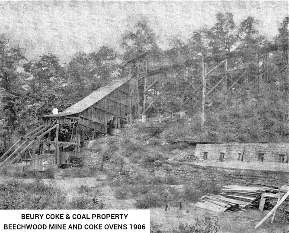
The Beury Coal and Coke Reserve surrounds the old town of Claremont, incorporated in the late 1800s. The Beechwood Coal & Coke Company opened its first mine at this location in 1887, and soon afterwards a second mine was opened. The mines were known as Beechwood Nos. 1 & 2. The location of No. 1 is shown on early maps as Beechwood, however, the name of the post office established in 1889 to serve the community was named Claremont. The post office was closed in 1942, but by then Claremont had become the name local residents associated with both the community and the mines.
In the 1960s, Royal Coal Company built a modern preparation plant atop the high plateau on the rim of the gorge. A 4000’ long conveyor belt connected the plant to two large storage silos and loading facilities below by the railroad track and river. It is said the plant was never put in operation due to a sudden downturn in the coal market and was dismantled. The remains of the 2 concrete coal storage silos and foundations of the load out facility, now surround by mature forest, are still visible.
RECREATION
The 198 acre Reserve offers unparalleled recreational opportunities. Numerous soft recreational activities are anchored by the adjoining New River.
Water-sports enthusiasts will find the New River ideal for swimming, canoeing, fishing, kayaking, tubing, snorkeling, paddle boarding and windsurfing. Great fishing is found in the New River with bass (largemouth,smallmouth and rock), flathead catfish, channel catfish, muskie and bluegill are present in good numbers. Ice skating is occasionally a fun activity during the winter months.
Nature viewing is first in line of recreational activities. Attentive wildlife management has been geared not to just larger animals. Equal consideration has been extended to increasing the numbers and diversity of species including neo-tropical songbirds, butterflies, turtles, frogs, rabbits, chipmunks, dragonflies, owls, eagles and hawks. White tail deer, black bear, red/gray fox, bobcat, wild turkey, grouse, duck, squirrel, raccoon, fox and rabbit make up the resident wildlife population. It is hard to find a property that has a better mix of wildlife.
Stargazing-Planet Observation
Total or near total darkness can be still be found on the property, thereby affording the opportunity to view the night sky in all its brilliant wonder.
Shooting-sports devotees find all the land and privacy needed to enjoy:
- Paintball-Airsoft-Laser Tag-Archery tag
- Shotgun sport shooting including Skeet, Trap, Double Trap and Sporting Clays
- Rifle & Handgun shooting: bullseye, silhouette, western, bench rest, long-range, fast draw
- Archery and Crossbow competition shooting
- Plain ole’ plinking: Grandpa’s old 22 single shot rifle and a few tin cans make a fun day
All Terrain Motorsports
The property is perfect for experiencing the property from an ATV or UTV. Riders are welcome to ride the property’s numerous interior trails and all public roads that do not have a painted dividing line – there are miles and miles of open roads in the area. These exciting machines handle the wide variety of the forest’s terrain.
Dirt bikes can also be a lot of fun and they come in all sizes and horsepower to fit anyone who enjoys being on two wheels.
Mountain Biking, Horseback Riding and Hiking
The land may be used for conventional and mountain biking, hiking or horseback riding and the area offers several state and national parks geared for these activities.
WATER
Direct access to the New River is just 100’ away crossing the National Park along the river.
The property is blessed with a dashed blue line clear water seasonal stream, flowing for about ½ mile inside the property. There are also several intermittent streams which run during snow melts and rain events. Water originating on the property flows just 300’ to the New River.
MINERAL RESOURCES
Various minerals may have been reserved and conveyed by prior deeds of record. The owner is conveying all the mineral rights in title.
UTILITIES
Water: Public water may possibly be available at roadside
Sewer: Septic systems would need to be installed
Electricity: Available onsite
Telephone: Available onsite
Internet: Available through Mobile hotspots, Satellite, or possibly phone line
Cellphone Coverage: Good in most places
BOUNDARIES AND SURVEY
There is not a recent survey of the boundary, however, about 90% of the boundary lines are common with the National Park and are painted and marked with National Park signage. Potential buyers are encouraged to have a land survey done before purchasing the property. The property is being sold by the boundary and not by the acre.
PREVIOUS MINING ACTIVITY
The property has a rich mining history dating back to the 1800s. All prospective buyers should retain an engineering firm to conduct a Phase 1 Environments Site Assessment to research the current and historical uses of the property prior to purchasing the property. The intent of the ESA report is to assess if current or historical property uses have impacted the soil or groundwater beneath the property and could pose a threat to the environment and/or human health. The property is being sold ‘AS IS, WHERE IS, WITH ALL FAULTS”.
ACCESS/FRONTAGE
The property has about 1 ½ miles of frontage on McKendree Road RT 25 of the public road system.
Right of way to the River. It may be that any owner of the Beury Coal and Coke Reserve has free access rights over a 47-acre tract of land that lies between the river and the railroad (now owned by the National Park Service. In a deed dated 1929, recorded in DB 68, about page 235, Beury Coal and Coke sold off a 47-acre portion laying between the railroad and the river. Beury Coal and Coke reserved rights unto itself, its successors or assigns, free access to the waters of the river across the land that was conveyed ( about 47 acres, now owned by the National Park Service), except in using for electro purposes, and to exercise such rights as to not to unreasonably interfere with the use of the land or waters by Electro, its successors or assigns.
ZONING
Fayette County is subject to some zoning and subdivision regulations. All prospective buyers should consult the County Commission and the Health Department for details regarding zoning, building codes and installation of septic systems.
PROPERTY TYPE/USE SUMMARY
The property is mostly forestland. Some areas along the county road where once cleared due to old mining activity some 60 to 130 years ago and are now regenerating back to forestland.
DEED and TAX INFORMATION
Deed Information: DB 465 Pg. 179
Fayette County, West Virginia
Acreage: 198.80 acres +/-
Real Estate Tax ID/Acreage/Taxes:
Fayette County (10), West Virginia
Plateau District (2)
Tax Map 40 Parcel 2; FEE 198.80 AC NR CLAREMONT; Class 3
2019 Real Estate Taxes: $1,075.53
FOREST/TIMBER RESOURCES
The Beury Coal & Coke Reserve is part of a globally significant forest containing the most diverse flora of any river gorge in the south and central Appalachian Mountains. The property has various ages of trees but mostly full canopy stands. The distinguishing features of the property’s timber resource is its unusually high hardwood stocking with a solid basal area per acre. This stocking may be well above average for the region. This well managed timber resource can provide a great deal of flexibility to the next ownership in terms of potential harvest revenue and can be managed to provide cash flow opportunities to offset holding cost and long-term asset appreciation.
Capital Timber Value and a forest-wide timber inventory have not been established by the owner at this time but should be of considerable commercial value.
The forest’s predominately well-drained upland terrain has led to a resource dominated by hardwood species. Overall, the species composition is highly desirable and favors Appalachian hardwood types, consisting primarily of White Oak/Chestnut Oak, Red Oak Group, Poplar/Cucumber/Basswood, Sugar Maple/Soft Maple and a host of associate species.
Stocking, Stem Quality, and Forest Structure:
Forest-wide, most stands are fully stocked, providing the next ownership with a great deal of flexibility in shaping their own silvicultural legacy. Stem quality forest-wide can be considered excellent with the forest containing an abundant current and future veneer source.
The timber component has been professionally managed over many decades and generally consists of two age classes managed using uneven and even-aged silvicultural guidelines. The predominant timber stand of the forest is comprised of 60-120-year-old trees that represent a mature forest.
20-50 year old stems ranging in size of 2-14” dbh is the second distinct stand. This stand is comprised of long-ago abandoned farm fields, and a mining site, coal storage areas (2 concrete silos) and old loading areas. These areas have naturally been restocked with pioneer species of poplar, locust and hickory. This stand is on the cusp of graduating into higher-value sawtimber diameter classes over the next 30 years.
Diameters are well represented across the commercial and pre-commercial spectrum with a notable mature size class, as well as abundant pole size timber and growing stock. Average diameter with all products combined has not been determined.
Some trees are well over 150 years old and classify as “Heritage Trees”. These amazing trees have withstood the test of time and lend an air of grace and permanency to the property.
The forest is healthy and there are no signs of pest infestations of Gypsy Moth. The Emerald Ash Borer and the Hemlock Wooly Adelgid are present and the majority of the Ash and Hemlock trees are severely stressed and will die out over the next decade. There have been no forest fires in the recent memory.
WILDLIFE
The mix of mature timber, adjoining New River, emerging forests, and miles of linear food plots, creeks and streams creates the perfect wildlife habitat. It is hard to find a property that has a better mix of wildlife and there has been intense game management for many years. The abundance of wildlife can be fully appreciated by spending a few hours hiking, looking and listening for all the forest has to offer.
The forest produces tons and tons of acorns, hickory nuts, walnuts, wild grapes, blackberries, beechnuts, poplar and maple seeds. Because there is such an amazing food source, there is a variety of wildlife, including wild turkey, white tail deer, black bear, raccoon, opossum, rabbit, grouse, coyote, squirrel, chipmunk and bobcat.
Many species of songbirds and woodpeckers thrive in the special habitat that large older trees and younger emerging stands create and make their home in this special forest environ.The dense forest, with its closed canopy, is home to a variety of neotropical song birds, owls, ravens, buzzards, woodpeckers and hawks, and woodpeckers. Many of these birds nest in the “den trees”, which are full of holes and cavities. The birds feed on a variety of insects, including hundreds of thousands small caterpillars that inhabit the upper reaches of the canopy.
A number of Bald Eagles have been spotted up and down the New River and are a thrill to see with wingspans of 6-7 feet.
A wide variety of insects, reptiles and amphibians are represented across Nature’s spectrum.
ADJOINING LANDOWNERS
Historic Beury Coal & Coke Reserve, with 198+/- acres, is surrounded by the National Park and West Virginia State lands, giving direct access to nearly 90,000 acres of managed wilderness beyond the property’s boundary.
New River Gorge National River – Borders for over 3 miles
Established in 1978, New River Gorge National River encompasses over 70,000 acres of land along 53 miles of the New River from Bluestone Dam to Hawk’s Nest Lake. A rugged, whitewater river flowing northward through deep and spectacular canyons, the New River is among the oldest rivers on Earth. In southern West Virginia, the New River continues to carve the deepest and longest river gorge in the Appalachian Mountains. One of the most exciting destinations for hiking, biking, climbing, and paddling in the eastern U.S. More than a million visitors annually climb rocks along the rim of the gorge near Fayetteville and paddle its whitewater runs on the New and its tributaries. Countless miles of hiking and biking trails wander the park and climb into the surrounding mountains. The nearby Gauley River National Recreation Area likewise attracts thousands of tourists annually, notably rafters during “Gauley Season” in autumn when the river runs strong.
Beury Mountain Wildlife Management Area – 1/10th Mile Common Boundary
The Beury Mountain Wildlife Management Area is located on 10,000 acres near Babcock State Park and New River Gorge National River in Fayette County, West Virginia. The area has sloping terrain covered with mixed hardwoods and oak-hickory second growth woodlands overlooking New River Gorge. The Wildlife Management area is comprised of large and broad mountaintop plateaus. Its gently sloping ridges and forest trails make foot travel easy. Wildlife abounds with grouse, deer, turkeys, squirrels and bears. Fishing for brook trout is available in Buffalo Creek.
Chesapeake and Ohio Railroad (CSX) – 1.5 Miles
In 1872, the Chesapeake & Ohio Railroad (now CSX) made its way into the New River Gorge, creating a major travel corridor along the river. The railroad opened up this rugged and isolated land and became a lifeline to the outside world and transported the coal and timber that helped fuel the industrialization of our nation.
In addition to the coal mines and company towns found throughout the gorge are the old railroad depots, rail yards, rail grades, railroad equipment, and associated towns, like nearby Thurmond, that were developed to support the railroad.
CSX maintains a 100’ wide rail line for about 1.5 miles along the southern border of the Beury property. The Beury property lays on the north side of the rail line and the New River National Park lays on the southern side of 100’ wide CSX rail line.
Today, some 14 trains travel the line daily delivering coal, industrial materials, consumer products and people (Amtrak) to destinations all over the US.
SURROUNDING AREA
The Beury Coal & Coke Reserve is part of a globally significant forest containing the most diverse flora of any river gorge in the south and central Appalachian Mountains. The Appalachian Mountain forests are some of the oldest and most diverse ecosystems in the world. Here in southern West Virginia, the New River has sliced through the mountains, creating a mosaic of habitats: unfragmented forest, cliff and rimrock habitats, forest seeps and wetlands, and mature bottomland forests. These habitats provide a refuge for endangered mammals and rare birds and amphibians, including the endangered Virginia big-eared bat and Indiana bat and the Allegheny woodrat, a species of special concern in West Virginia and in decline throughout the eastern United States.
The waters of the New River system contain a mosaic of hydrologic features and aquatic habitats that support a highly productive aquatic ecosystem that includes distinct populations of native fish, mussels, crayfish, and a broad array of other aquatic life, including rare amphibians, reptiles, birds, and mammals.
The area is one of the most popular outdoor-recreation destination areas in West Virginia — a paradise of natural and cultural amenities found in few other places in the eastern U.S. More than a million visitors toured the region in 2017, according to the National Park Service, climbing rocks, paddling streams, and hiking, biking, and running miles of scenic trail. Winter in the mountains attracts yet another recreational clientele — skiers bound for the slopes at Winterplace, a drive of 40 minutes to the south, and Snowshoe Mountain, a drive of two-and-a-half hours to the northeast.
Nearby is Adventures on the Gorge, one of the most enduring and popular adventure resorts in the U.S., a pioneer in the whitewater rafting industry that has helped set the stage for high-end economic development in the region.
As a result of its burgeoning tourism market, the area also enjoys more than its share of singular shops and restaurants, many of which cluster around Fayetteville, a drive of five minutes from the villa. Other exceptional eateries and retail destinations are located an hour west at Charleston, the state capital, and an hour east at Lewisburg, one of the most livable small towns in the U.S., according to National Geographic. The region is also renowned for great golf, and more than a score of courses are located within a short, including three at The Greenbrier, home of the PGA tour, and Oakhurst Links, the first course built in the U.S.
The region is easy to access. As remote as the region may seem, an expressway courses through its center, spanning the gorge by way of the New River Gorge Bridge only a few miles away. Interstates 77 and 64 and US 19 and US 60 are only a half hour’s drive. Amtrak passenger stations on the Chicago-New York route are located 10 minutes away at Thurmond. Jet airports are located an hour away at Beckley and Charleston and Lewisburg.
The Old Town of Claremont
The Beury Coal and Coke Reserve surrounds the old town of Claremont, incorporated in the late 1800s. The Beechwood Coal & Coke Company opened its first mine at this location in 1887, and soon afterwards a second mine was opened. The mines were known as Beechwood Nos. 1 & 2. The location of No. 1 is shown on early maps as Beechwood, however, the name of the post office established in 1889 to serve the community was named Claremont. The post office was closed in 1942, but by then Claremont had become the name local residents associated with both the community and the mines.
Historic Thurmond
The historic town of Thurmond is just 4 miles downriver from the property. Presently, the National Park owns approximately 80% of the town of Thurmond, including the historic Thurmond Depot. Three times each week, Amtrak uses the Thurmond Depot as a passenger stop and coal trains continue to roll through town daily. The town’s population is 5, all of whom sit on the city council.
The town of Thurmond was no more than a man’s dream in April of 1873 when Captain William D. Thurmond received 73 acres of land as payment for his services as a surveyor. With access to the newly completed C&O Railroad, as well as the rich coalfields of Southern West Virginia, the soon-to-be named town of Thurmond was positioned to become an important cog in both the coal and rail industries. It was not until the late 1880’s with the completion of the Southside Junction railroad bridge that crosses the New River at the mouth of Dunloup Creek that Thurmond saw its prosperity and important to the area grow.
The town of Thurmond was incorporated in 1903. In the following years, Thurmond’s population and economy boomed. The town’s steam engine repair shop was one of the primary reasons for its success. The raucous nature of Thurmond’s neighbor across the river, Dunglen, has also been credited as an aid to Thurmond’s thriving economy.
Thurmond’s importance started to deteriorate when roads arrived in 1917. Around that time, two major fires, one that burned through the south side of Thurmond in 1922 and the Dunglen Hotel fire in 1930, destroyed much of the town’s infrastructure and many establishments moved away. The final blow to the rail industry in Thurmond came in 1949 when the C&O Company purchased its first diesel engine and began phasing out its steam engines.
Commercial whitewater rafting came to Thurmond with the founding of Wildwater Unlimited in 1968. The outdoor adventure business has continued to grow in and around the town of Thurmond. In 1987 the National Park Service established the protected area know today as the New River Gorge National River.
Though it is a shell of its former self, the historic town of Thurmond still stands as a reminder of the past. It truly is where the River meets History!
The Old Town of Beury
Located 6 miles downriver from the property is the old town of Beury. J.L Beury created the mining town of Beury in the 1870s. Here Beury built a fine house in which he, his wife and four children lived. Stone used in the home’s foundation was reportedly imported from Germany, and the total cost of building the house was said to be $100,000. The house had 23 rooms with swimming pool, stone gardens, a greenhouse, and stables on the grounds of residence. Today, there are only the home’s stone foundation left as the home burned decades ago.
Town of Fayetteville
Fayetteville’s historic district is both charming and one of the most attractive locations for outfitters shops, boutique shops, and specialty restaurants in West Virginia. More than a dozen antiques shops were operating in the Fayetteville area in summer 2017, and five independent restaurants in the district were offering an outstanding selection of unique cuisine. Fayetteville is central to the travel-destination area as well as the legal center of the Fayette County. Its population in 2014 was estimated at 2,892.
City of Oak Hill
Oak Hill is Fayette County’s largest municipality and its economic center. Its population in 2010 was estimated at 7,730. Plateau Medical Center, the largest hospital in the county, is located off the US-19 expressway on Main Street in its downtown. The city has recently increased its investment in recreational and quality-of-life improvements and has acquired land for the new outdoor-adventure park approaching the edge of the New River Gorge.
The Summit: Bechtel Family National Scout Reserve
As a result of unrivaled access to recreation, the Boy Scouts of America established its national Jamboree site here encompassing 12,000 acres and has invested over $300,000,000 in the acquisition and buildout of the site.
The Summit is the home of the World Jamboree as well as the National Scout Jamboree. The Summit is the national leadership center for the Boy Scouts of America as well as one of the organization’s five high-adventure bases. More than 50,000 scouts and leaders from all over 40 countries attended the World Jamboree in 2019.
HISTORY
Joseph L. Beury, an early coal industrialist and founder of Beury Coal and Coke, started mining operations in the New River area in the 1870s. J.L. Beury owned hundreds of thousands of acres in the New River Gorge area where he opened up vast areas for the mining of coal and harvesting timber. Today, the descendants of J.L. Beury continue to actively manage some 18,000 acres in the area. Much of the land that the Beury’s owned is now preserved by the National Park and WV State Park lands.
J.L Beury created the mining town of Beury in the 1870s. Here Beury built a fine house in which he, his wife and four children lived. Stone used in the home’s foundation was reportedly imported from Germany, and the total cost of building the house was said to be $100,000. The house had 23 rooms with swimming pool, stone gardens, a greenhouse, and stables on the grounds of residence. Beury was said to frequently hire orchestras to play on the lawn of the Beury home on Sunday evenings during the summer months. Beury died at his residence in Beury on June 2, 1903. His wife died in 1917, and afterwards the Beury house was occupied by their son, Harry B. Beury, his wife and six children. Beury was located at Mile Post 393.2. The mile posts along the railroad indicated the distance from Fort Monroe, Virginia.
The town of Claremont, now surrounded by the property, was the site of the Beechwood Coal & Coke Company listed as operating two mines at a station named Beechwood, with 30 coke ovens in operation. The No. 1 mine had a daily capacity of 650 tons, and the No. 2 mine’s capacity was 450 tons per day. The No. 1 mine had the capacity to produce 1 car of coke per day. By 1910 the population of Claremont was 593, according to the West Virginia Geological Survey of 1919.
The earliest people in the New River area were the generations of the Native American Indians; believed to be the Shawnee, Cherokee, and Delaware tribes. In the 1750s and early 1800s, settlers made their way into the area. In the middle 1800s, the Chesapeake & Ohio Railroad made its way into the New River Gorge, making a major travel corridor along the river.
Half way down the side of the gorge was a thick seam of bituminous coal of such high grade it was considered to be smokeless because of the very low content of impurities and burned clean. The existence of this and other coal seams throughout the region made coal a “King” industry in the state of West Virginia for many years. Coal was mined in the gorge, taken down to the river, loaded in train cars for shipment or placed into the many beehive ovens along the railroad tracks to make coke. The very high-grade coal burned with great heat. The coal that was shipped out was highly desired to heat homes in the northeast United States, use in the steel making industry, and fire boilers in ships throughout the world. The coke that was made by the beehive ovens in the gorge had very low levels of impurities and produced very high temperatures when burned in the United States steel-making industry. Some trains leaving the gorge carried only the smokeless bituminous coal while others carried only the highly needed coke.
The 1960’ where the last years of active coal mining and coal coking in the gorge. From the late 1800s through the 1940s, there were over 20 thriving communities along the New River in the gorge. Most were accessible only by railroad. To travel from one town to the next, residents either caught one of the many trains passing through or walked the railroad.
Most of the coal miners and their families lived in the towns along the railroad by the river. Those families depended on daily living supplies as brought in by train and sold at the company stores. The current Beury C&C property contained one such small community, known as Claremont. Over time, as the coal mining in the gorge declined, the small community, along with most of the others, ceased to exist.
Timber harvesting was a thriving industry in the gorge up until the 1980’s, when much of the land started to be purchased for the National Park. Vast virgin forests where harvested between 1880 and 1920 to supply the lumber, railroad ties and heavy bridge and construction timbers supplying the timber and lumber that helped fuel the industrialization of our nation.
These neighboring lands and towns were named for large and important people and companies in the history of the area, such as Babcock Coal and Coke Company, Joseph L. Beury, who started mining operations in the New River area in the 1870s, the mining town of Beury, and Sewell Lumber Company. A little distance away was the community of Nuttallburg, associated with John Nuttall, one of the earliest mining pioneers, who came to the New River area in the 1870s. The Nuttall mine was sold to the Fordson Coal Company, owned by Henry Ford. The Nuttallburg area is a current scenic attraction. Much of the property in the area still remains in the Nuttall family.
NEW RIVER OVERVIEW
The New River is shared by boaters, fisherman, campers, park visitors and local neighbors. The waters of the New River system contain a mosaic of hydrologic features and aquatic habitats that support a highly productive aquatic ecosystem that includes distinct populations of native fish, mussels, crayfish, and a broad array of other aquatic life, including rare amphibians, reptiles, birds, and mammals.
The 320-mile New River rises in the Blue Ridge region of North Carolina and flows northeastward through the Appalachian uplands to Radford, Va., where it turns northwestward and passes through a series of narrow valleys and gorges into southern West Virginia. It ends where it joins the Gauley River to form the Kanawha River. In WV, the New River is entrenched in a steep and narrow valley, the most narrow part of which is known as the “New River Gorge.”
In 1998, because of historical, economical, and cultural importance, President Clinton signed into law the New River as one of the very first American Heritage Rivers. Much of the river’s course through West Virginia is designated as the New River Gorge National River.
The New River is recognized as the “second oldest river in the world” and is estimated to be between 10 and 360 million years old. Its headwaters begin near Blowing Rock, NC and is one of the few rivers in North America that flows northerly.
Class I, II, III, IV and V rapids dot the entire 320 miles of New River making it a great paddling, tubing, and white rafting adventure. Beautiful cliffs, bluffs, and mountain views make it one of the most scenic rivers on the east coast.
New River Gorge National River includes 53 miles of free-flowing New River, beginning at Bluestone Dam and ending at Hawks Nest Lake. The New River typifies big West Virginia style whitewater. Within the park it has two very different characters. The upper (southern) part of the river consists primarily of long pools, and relatively easy rapids up to Class III. It is a big powerful river, but very beautiful, always runnable, and providing excellent fishing and camping. There are a number of different river access points, and trips can run from several hours to several days.
The lower (northern) section of river is often referred to as “the Lower Gorge.” In a state that is justifiably renowned for colossal rapids, the Lower Gorge has some of the biggest of the big with rapids ranging in difficulty from Class III to Class V. The rapids are imposing and forceful, many of them obstructed by large boulders which necessitate maneuvering in very powerful currents, crosscurrents, and hydraulics. Some rapids contain hazardous undercut rocks.
Prior to the rise of the Appalachian Mountains, the New River cut its bed at a time when the land sloped to the northwest. Amazingly so, as the Appalachians gradually rose around the river, the New River wore away the bedrock at the same rate the mountains formed, leaving behind towering cliffs and prominences that hover hundreds of feet about the water level.
Accounts claim that Indians referred to the New River as the “river of death,” however this origin story is likely legend. Native Americans and early European settlers regarded the New and Kanawha rivers as being one single waterway. The name “New” may have been derived when the river upstream was discovered by European explorers as the first “new” river found flowing westward.
Native American Indians used the New River as they traveled west years before the pioneers arrived. In the 1600s explorers navigating the New River thought they were close to the Pacific Ocean because of its westerly flow.
In 1671 the Batts-Fallam expedition, by way of the New River, came through to the Lurich area and ended there because the Indian guides refused to take them any farther. They carved their initials in a tree and claimed the territory for King Charles II of England. This was the first proclamation of English territory west of the Alleghenies making the New River the first gateway into the west.
Fast water, big rocks and lazy/slow stretches are features of the New River. Water sports enthusiasts will find the New River ideal for swimming, canoeing, fishing, kayaking, tubing, snorkeling, paddle boarding and windsurfing. Great fishing is found in the New River with bass (largemouth, smallmouth and rock), flathead catfish, channel catfish, muskie, walleye and bluegill present in good numbers.
The gorge was practically impassible before completion of the New River Gorge Bridge, near Fayetteville, WV, in 1978. The river within its gorge is one of the most popular whitewater rafting destinations in the eastern U.S. Much of the New between Hinton and Gauley Bridge is managed by the National Park Service as the New River Gorge National River.
Principal tributaries of the New in West Virginia include, from south to north, the East River, the Bluestone River, and the Greenbrier River.
Many former mining communities located on the New River in its gorge have since become ghost towns. These include Sewell, Nuttalburg, Kaymoor, Fayette, South Fayette, Hawks Nest, Cotton Hill, and Gauley, Beury and Claremont.
GEOLOGY
Geologist’s estimates vary widely from 3 million years to 320 million years when talking about the age of the gorge. The river pushes its load of sand and other particles over the bedrock of the river channel and wears it down in a sandpapering action. The cutting takes place very slowly and each foot cut may take thousands of years.
Erosion by the New River has exposed several different rock formations. Traveling the 52 miles between Hinton and the New River Gorge bridge you will pass through a cross section of the earth’s surface, exposing sedimentary rock layers totaling about 4,000 feet in thickness. It may have taken 7 to 10 million years for these deposits to accumulate as layers of sand, mud, and rotting plants and then compressed and bonded into sandstone, shale, and coal.
ARCHEOLOGY
The New River Gorge was never permanently settled by Europeans prior to the 1850’s, so the older archeological record begins with the very rich story of the Native American Indians in the New River Gorge area of southern West Virginia. Most of the stories involving native peoples center on “historically” documented tribes and their interaction with the European and African peoples who came into this area in the mid-1600s. What we usually consider the beginning of the story is actually an ending.
The story of American Indians in West Virginia began hundreds of generations before the written history. The keys to this amazing story are literally found in the arrowheads and multitudes of other artifacts and historic sites left behind by these ancient peoples.
The oldest artifacts from New River Gorge are Clovis points. Made more than 11,000 years ago over much of North America, these intricately shaped stone spear points were used by ancient nomadic hunter-gatherers, Paleoindians, to kill mammoth, mastodon, and other Ice Age creatures.
Later artifacts found in excavated village sites, such as pieces of pottery, stone and bone tools, seeds, beads, and arrowheads, show the development of thriving agricultural-based permanent communities connected by well-established systems of trails.
Peoples of the Archaic and Woodland periods lived in our area for thousands of years (from approximately 8,000 B.C.E. to 1,200 C.E.), constructing palisade villages and elaborate burial mounds, progressing from spears to bow and arrows, producing clay and stone pottery and art objects, and extensively cultivating corn, squash, and beans. They were the ancestors of the people we know of today in eastern North America as the Cherokee and Shawnee
CARBON SEQUESTRATION
The 198+/- acres of forest is a tremendous producer of Oxygen and Carbon Sequester. Carbon Sequestration is the act of processing carbon dioxide through sinks and stores and releasing them into the atmosphere as oxygen. With nearly 200 acres, the vigorously growing forest is sequestering thousands of tons of Carbon Dioxide each per year.
On average, one tree produces nearly 260 pounds of oxygen each year so the forest may be producing about 1,000,000 pounds of life-giving Oxygen a year.
FAYETTE COUNTY
Recreation is a high-income producer for Fayette County and the bordering counties of Nicholas, Raleigh, Summers and Greenbrier, located in southern West Virginia, renowned for its dramatic landscapes, small communities, and outdoor recreation amenities. White water rafting, the 80,000-acre New River National Park, 4,000 acre Babcock State Park, 9,000 acre Beury Mt. Wildlife Management Area, 14,000 acre Boy Scout High Adventure Camp, ACE Adventures OTG and many other attractions bring the out-of- area and out-of-state population to the area. Along with this, many people want to have a vacation spot, recreation home or other tie to the area. Hunting and fishing is very popular as well as ATV adventuring on the Hatfield-McCoy Trail.
SCHOOLS
Fayette County School District
Public Elementary School:
Mount Hope Elementary School
Public Middle School:
Collins Middle School
Public High School:
Oak Hill High School
Public College:
Fayette Institute of Technology
WVU Tech – Beckley
DIRECTIONS
From Glen Jean, WV: 8.8 miles +/- (approximately 20 minutes)
From the Exxon Gas Station / Convenience Store at the Glen Jean exit off RT 19 (between Oak Hill and Mount Hope), travel RT 16 North toward Glen Jean for 4/10 mile; just before the “Cold Spot”, turn right onto Glen Jean Lane toward Thurmond; travel a very short distance crossing the bridge; turn left just before the historical stone former bank building onto McKell Avenue; travel a very short distance; turn left onto Thurmond Road; travel Thurmond Road 6.1 miles; turn right onto McKendree Road RT 25; travel 2.2 miles (at 1.5 miles, RT 25 turns left, crosses the New River, and immediately turns right) to about the place where RT 25 begins traveling through the property (about 3/4 mile after crossing the river).
From Beckley, WV: 14.6 miles +/- (approximately 30 minutes)
From the Crossroads Mall at Beckley, travel RT 19 North 6.3 miles to the Glen Jean exit; turn right toward the Exxon Gas Station / Convenience Store; at the Exxon Station, turn left and travel RT 16 North toward Glen Jean for 4/10 mile; just before the “Cold Spot”, turn right onto Glen Jean Lane toward Thurmond; travel a very short distance crossing the bridge; turn left just before the historical stone former bank building onto McKell Avenue; travel a very short distance; turn left onto Thurmond Road; travel Thurmond Road 6.1 miles; turn right onto McKendree Road RT 25; travel 2.2 miles (at 1.5 miles, RT 25 turns left, crosses the New River, and immediately turns right) to about the place where RT 25 begins traveling through the property (about 3/4 mile after crossing the river).
From Oak Hill, WV: 11 miles +/- (approximately 25 minutes)
Travel RT 19 South 2.5 miles to the Glen Jean exit; turn left toward the Exxon Gas Station / Convenience Store; at the Exxon Station, turn left and travel RT 16 North toward Glen Jean for 4/10 mile; just before the “Cold Spot”, turn right onto Glen Jean Lane toward Thurmond; travel a very short distance crossing the bridge; turn left just before the historical stone former bank building onto McKell Avenue; travel a very short distance; turn left onto Thurmond Road; travel Thurmond Road 6.1 miles; turn right onto McKendree Road RT 25; travel 2.2 miles (at 1.5 miles, RT 25 turns left, crosses the New River, and immediately turns right) to about the place where RT 25 begins traveling through the property (about 3/4 mile after crossing the river).
REGIONAL INFORMATION
STATE INFORMATION
- State of West Virginia
- West Virginia Explorer
- West Virginia Government
- West Virginia State Parks
- West Virginia Tourism
- Wonderful West Virginia Magazine
- WV Department of Natural Resources
- Virginia – Commonwealth of Virginia
- Virginia is for Lovers
- Virginia Museum of History & Culture
- Virginia Museum of Natural History
- Virginia National Park Service
- Virginia Recreation
- Virginia State Parks

Contact Foxfire
304.645.7674
Gallery


