BURNSVILLE LAKE FOREST

| Price: | |
|---|---|
| $499,500 | |
| ID: | 1107 |
| Acres: | 312 +/- |
| Address: | Little Knawl Road, Napier, WV 26631 |
Agent Contact:
Richard Grist, 304.645.7674


HIGHLIGHTS
- Exceptional off-grid living
- Free natural gas available for residential use
- Contiguous three hundred -twelve acre +/- acre multi-use parcel in the heart of a recreational powerhouse in the geographical center of West Virginia
- Ten minutes to the nine hundred eighty-nine-acre Burnsville Lake
- Adjoins the 12,579-acre Burnsville Lake WMA for one and a half miles
- Recreation at Burnsville Lake Forest offers outstanding onsite recreational opportunities
- The property has many ridges, several major hollows, ½ mile long blueline stream, and several ephemeral creeks creating a diverse and interesting topography
- Superb regional recreational opportunities
- Ten rivers and six lakes are within an easy ten minutes to two hour drive
- A blue line mountain stream flows through the property for 4/10 mile
- Miles of internal forest management roads, plus miles of forest trails, offer excellent access to a large portion of the forest
- Perfect for shooting sports, ATV riding, horseback riding, hiking, camping, hunting and nature viewing
- The town of Flatwoods is a 20-minute drive
- High percentage of commercially – operable ground supporting forestry, recreation and potential for numerous future cabin sites
- Elevations range from 2147 ft. to 2455 ft. +/-
- Potential conservation value
- Low taxes, low population density, little or no light pollution
- Great fishing is found in the Heartland’s region with ten rivers and six lakes. Species include small and large mouth bass, crappie, catfish, muskie, walleye, pike and bluegill
- The rivers and lakes are ideal for swimming, canoeing, fishing, kayaking, tubing, snorkeling, paddle boarding and windsurfing
- Forest is a steady producer of life-giving Oxygen and silently works to sequester carbon
- Several decades of professional forest and wildlife management
- As the trees continue to grow, there will be very valuable hardwood timber available to harvest
- Jet airports less than a sixty-minute drive
- Potential for leasing carbon credits

LOCATION

Google Coordinates: 38.810494°(N), -80.551211°(W)
Address: Little Knawl Road, Napier, WV 26631. No 911 address is assigned to property without structures.
Elevation Range: 868 ft. to 1487 ft. +/-
Driving Times
Highways/Towns
- I-79 at Flatwoods Exit 67: 30 minutes
- I-79 at Burnsville-Glenville Exit 79: 30 Minutes
- Buchannon: 55 minutes
- Burnsville: 30 minutes
- Clarksburg: 1 hour 10 minutes
- Elkins: 1 hour 15 minutes
- Flatwoods: 30 minutes
- Glenville & Glenville State University: 55 minutes
- Summersville: 1 hour
- Weston: 50 minutes

Airports
- Braxton County Airport (small), Sutton: 30 minutes
- Elkins-Randolph County Regional Airport: 1 hour 30 minutes
- Upshur County Regional Airport, Buchannon: 55 minutes
Recreation
- Burnsville Lake Wildlife Management Area: 5 minutes
- Elk River Wildlife Management Area, Sutton: 50 minutes
- Golf Course, Stonewall Jackson Resort: 40 minutes
- Lake – Burnsville Lake – Bulltown Campground and boat ramp: 10 minutes
- Lake – Sutton Lake: 35 minutes
- Lake – Stonewall Jackson Lake & Resort: 40 minutes
- Lake – Summersville Lake: 1 hour 10 minutes
Google Coordinates: 38.810494 (N), -80.551211 (W) on road in front of camper spot
DIRECTIONS
From I-79 Flatwoods Exit 67: 13.4 miles +/- (approximately 25 minutes)
At the end of the exit ramps, turn toward US 19 North getting into the left turn lane, go short distance, turn left onto US 19 North, travel US 19 North for 11 miles; after crossing the headwaters of Burnsville Lake, turn left onto Millstone Run Road Rt. 19/12; travel 2.4 miles; turn left onto Little Knawl Road Rt 4/4; the camper field is on the right.
SELF SUSTAINING LIFE OFF THE GRID
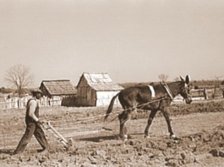
Just as 150 years ago, when the first mountaineers settled the area, the property can be self-sustaining in times of necessity – even without electricity.
- Fresh water for drinking and cooking can come from mountain springs or a drilled water well (hand drawing water from the well using a cylinder well bucket).
- The creeks and forest can provide fresh food (deer, squirrel, rabbit, and turkey).
- Clearing land for agriculture can provide vegetable gardens, berry patches, fruit orchards, and row crops of corn, oats and barley.
- Bee hives can provide honey and beeswax for candles and pollenate the fruit trees.
- The forest can provide firewood for heating and cooking, lumber for building, maple syrup and pounds of nuts (walnuts, beechnuts and hickory nuts).
- A vineyard could be created to provide jellies, jams, juices and wines.
- Livestock can be raised including dairy cows, chickens, geese, turkey, rabbits, goats, sheep, pigs and cattle. Milk, cheese, eggs, meat, wool, leather, fur, feather pillows and down comforters can all be produced.
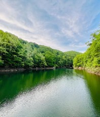
WATER
A dashed blueline branch (intermittent water flow) of Little Knawl Creek begins on the property and travels on the property for about ½ mile. Little Knawl Creek, a blueline stream, is on the property periodically as it travels along the road and property boundary. The streams should have regular water flow, especially during snow melt and rain events.
MINERAL RESOURCES
West Virginia is one of the states in the US that has two ownership titles, those being SURFACE RIGHTS and MINERAL RIGHTS. This is a SURFACE ONLY conveyance as the mineral rights have been reserved in the owner’s deed.
BOUNDARIES AND SURVEY
Directly joins the Burnsville Lake Wildlife Management Area for about one and a quarter miles. The property is being sold by the boundary and not by the acre.
UTILITIES
Free Natural Gas
Water: Well could be drilled
Sewer: Private septic could be installed
Electricity: Currently Off Grid. Solar is very feasible
Telephone: Cell coverage is good
Internet: Starlink service is best option
Cellphone Coverage: good depending on carrier
ACCESS/FRONTAGE
The property is accessed by Little Knawl Road Rt. 4/4.
ZONING
Braxton County has no zoning regulations in effect other than those which are enacted and enforced within the municipalities. All prospective purchasers are encouraged to contact the Braxton County Health Department and the county commission regarding installation of septic systems, water wells, and flood insurance requirements.
PROPERTY TYPE/USE SUMMARY
This property currently is forestland containing an open-area natural gas line that runs through a portion of the property.
(This summary is an estimation of current property use as determined from aerial photography. It is made subject to the estimation of property boundaries and any errors in the interpretation of land use type from the aerial photography utilized.)
DEED and TAX INFORMATION
Deed Information: DB 636 Pg. 329
Braxton County, West Virginia
Acreage: 312.622 acres +/-
Real Estate Tax ID/Acreage/Taxes:
Braxton County (4), West Virginia
Salt Lick District (7)
Tax Map 12F Parcels 9 and 9.2; Class 3
Tax Map 13F Parcels 1 and 1.1; Class 3
2024 Real Estate Taxes: $1217.64
SCHOOLS
Braxton County School District
Public Elementary School:
Flatwoods Elementary School
Public Middle School:
Braxton County Middle School
Public High School:
Braxton County High School
HEARTLAND REGION
At and near the center of West Virginia, the Heartland Region includes some of the Mountain State’s most archetypal landscapes of hill and valley. Here at the heart of West Virginia you’ll encounter the most West Virginian of West Virginias, as the saying goes. Fields have been farmed, coal has been mined, forests have been timbered, and oil and gas have been drilled in the heartland, but none of these industries have dominated. Most residents continue to operate small farms, though camps and vacation properties are being developed throughout the region, particularly near its lakes and rivers. The Elk, Hughes, Little Kanawha, and Pocatalico rivers course sleepily through the heartland.
The West Virginia Heartland Region includes Wirt, Roane, Ritchie, Gilmer, Calhoune, and Braxton counties and parts of Clay, Lewis, Upshur, Webster, and Nicholas counties. The region roughly corresponds to the Mountain Lakes travel region of the West Virginia Department of Commerce.

Interstate 79 travels through the southern reaches of the West Virginia Heartland between Charleston, in the southwest, and Clarksburg, in the northeast. The US-50 expressway courses east to west across the northern region between Parkersburg, in the west, and Clarksburg, in the east. Highways US-33 and US-119 travel through the southern areas of the region through Spencer and Glenville.

Mountain Lakes Travel Region: The lakes of this region – Stonewall Jackson, Stonecoal, Summersville, Summit, Sutton, and Burnsville — all offer outdoor fun for everyone. Enjoy swimming, snorkeling, water-skiing and boating on all six. Fishing, hunting, biking, and bird watching are popular here, and rock climbers love the ledges at Summersville Lake. This region also holds an abundance of arts, crafts, and boutique shopping. Admirers of handcrafted glass can visit factories, outlets, a glass museum and watch individual artisans in action.
BURNSVILLE LAKE – 968 ACRES

One of the largest lakes in central West Virginia, Burnsville Lake, at 968 acres, is equipped with three wheelchair-accessible boat ramps and accommodates fishing for bass, trout, walleye, crappie, bluegill and catfish. It is stocked with trout from February through May. The area supports Class-Q hunting access and game traditionally hunted in the management area includes deer, grouse, rabbit, raccoon and turkey. More than 260 tent and trailer campsites and six primitive campsites are in the Burnsville Wildlife Management Area.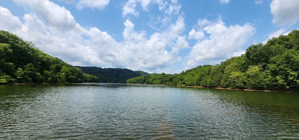
FUN FACTS: Burnsville Lake is both a recreational and flood control reservoir on Little Kanawha River located southeast of Burnsville in Braxton County, West Virginia. Burnsville Lake was authorized by the U.S. Congress in the Flood Control Act of 1938. Construction of the Burnsville Lake project was begun in the summer of 1972 and the dam was completed in September 1976. The lake project controls the runoff from a drainage area of 165 square miles.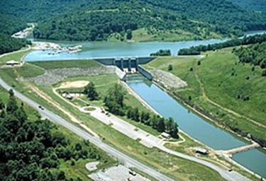
The dam is a rock-fill embankment dam rising 84.5 feet above the streambed. Top elevation is 839 feet above sea level, and the crest length is 1,400 feet. A gated spillway is in the left abutment. The outlet works are in the spillway section. The minimum pool is maintained at elevation 776 feet with a surface area of 550 acres. The summer pool is at elevation 789 feet and has a surface area of 968 acres. The flood control pool is at elevation 825 feet with a surface area of 1,900 acres.
Directions: Burnsville Lake is in northern Braxton County three miles east of Burnsville, WV, off I-79 and six miles northeast of Flatwoods, WV.
Reprinted with the permission of David Sibray, Editor WV Explorer, Historian, and Foxfire Realty Agent.
BURNSVILLE LAKE WILDLIFE MANAGEMENT AREA – 12,579 ACRES
property adjoins the 12,579-acre Burnsville Lake Wildlife Management Area (WMA) for one and a half miles. The WMA protects old farm fields and young forests on gentle uplands along the Little Kanawha River. One of the largest lakes in central West Virginia, Burnsville Lake, at 968 acres, is equipped with three wheelchair-accessible boat ramp and accommodates fishing for bass, trout, walleye, crappie, bluegill, and catfish. It’s stocked with trout February through May. The area supports Class-Q hunting access, and game traditionally hunted in the management area includes deer, grouse, rabbit, raccoon, and turkey. More than 260 tent and trailer campsites and six primitive campsites located in the Burnsville Wildlife Management Area.
Burnsville Lake WMA is managed by the W.Va. Division of Natural Resources in cooperation with the U.S. Army Corps of Engineers. The management area was formerly known as the Burnsville Lake Public Hunting & Fishing Area. The Bulltown National Historic District and Falls Mills Picnic Area are located on the lake at Falls Mills, WV. The management area is located approximately seven miles north of the 18,225 acre Elk River Wildlife Management Area, the site of 1,520 acre Sutton Lake.
Directions: The Burnsville Lake Wildlife Management Area is located in northern Braxton County three miles east of Burnsville, WV, off I-79, and six miles northeast of Flatwoods, WV.
Reprinted with the permission of David Sibray, Editor WV Explorer, Historian, and Foxfire Realty Agent.
SUTTON LAKE – 1520 ACRES
Sutton Lake is a 1,520-acre reservoir on the Elk River in Braxton and Webster counties, located just upstream of Sutton West Virginia. Sutton Lake is just a 20 minute ride from the property. It was authorized by Congress in the Flood Control Act of 1938. Construction of the dam began in 1956 and was completed in 1961. The dam is 210 feet high, 1,178 feet long, and constructed of concrete.
Sutton Lake was formed by impounding the Elk River in Sutton in 1961. The lake is typically uncrowded, the water skier, wake boarder, jet skier and tuber can easily find that elusive glass-like water for carving and the fishing is spectacular. In fact, over 60 bass tournaments are held at Sutton Lake annually and crappie are plentiful also.

Sutton Lake fishing offers a picturesque setting for fishing enthusiasts in the heart of West Virginia. With moderate temperatures ranging from 60-80°F during the popular fishing season of spring to early fall, anglers can enjoy comfortable weather conditions. The lake is surrounded by lush forests, providing a tranquil escape for outdoor adventurers. Renowned for its abundance of bass, catfish, and walleye, Sutton Lake is a prime spot for both novice and experienced fishermen.
The area also boasts convenient amenities such as marinas, boat ramps, and camping grounds, ensuring a seamless and enjoyable fishing experience. For those seeking a reliable fishing spot with diverse options, fishing in Sutton Lake is the perfect destination. Be sure to check out the Sutton Lake fishing map for the best fishing spots and stay updated on weather conditions before heading out.
ELK RIVER
The Elk River, a 172-mile tributary of the Kanawha River, drains about 1,550 square miles in central West Virginia (WV) and in the western Allegheny Mountains. The river rises in western Pocahontas County and flows northward across the southern corner of Randolph County, near Snowshoe Mountain, the high point in its drainage, afterwhich it turns westward and descends across Webster County, Braxton County, Clay County, and Kanawha County. It empties into the Kanawha River at Charleston, WV. The river is impounded near Sutton at Sutton Lake, centerpiece of the Elk River Wildlife Management Area.
The Elk River provided the water transportation route needed to float large rafts of logs and crossties, as well as large freight canoes, out of the forests of central and eastern West Virginia in the late 1800s and early 1900s. The Elk lost its importance in this respect after the advent of railroads such the West Virginia Coal & Coke Railroad and the Baltimore & Ohio Railroad.
Some sources claim the Shawnee called the Elk River “Tis-kel-wah,” meaning “river of fat elk.” The Delaware tribe is said to have called it “Pe-quo-ni,” meaning “the walnut river.”
Variant names are Dry Fork, Pe-quo-ni, Pe-quo-ni-cepe, Pequoni, Tis-chil-Waugh, Tiskelewah, Tiskelwah, To-que-man, To-qui-min-cepe.
From source to mouth, the following select cities, towns, and villages are located on or near the Elk River.
Slatyfork, WV
Webster Springs, WV
Centralia, WV
Sutton, WV,
Gassaway, WV
Frametown, WV
Strange Creek, WV
Duck, WV
Ivydale, WV
Clay, WV,
Clendenin, WV,
Blue Creek, WV
Elkview, WV
Pinch, WV
Big Chimney, WV
Charleston, WV
ELK RIVER WILDLIFE MANAGEMENT AREA – 18,225 ACRES
The 18,225-acre Elk River Wildlife Management Area (WMA) is just a 20 minute ride from the property. The WMA is forested in mature hardwoods, which climb steeply from the banks of Sutton Lake and the Elk River. The area accommodates Class-Q hunting access, and game traditionally harvested include deer, squirrel, turkey, and waterfowl. Sutton Lake, at 1,440 acres, is equipped with five boat ramps with wheelchair access and accommodates fishing for trout, bass, walleye, bluegill, catfish, and muskellunge. The Sutton Lake tailwaters are stocked with trout from February through May and during Columbus Day week. More than 240 tent and trailer campsites have been developed in the management area, as well as 12 primitive campsites. A 100-yard and 175-yard shooting range are on site.
The Elk River WMA is managed by the W.Va. Division of Natural Resources. It was formerly known as the Elk River Public Hunting & Fishing Area. The management area is located approximately seven miles south of the Burnsville Lake Wildlife Management Area, the site of Burnsville Lake.
Directions: The Elk River Wildlife Management Area is located in eastern Braxton County east of Sutton, WV. To reach the area from expressway I-79 exit 67 at Flatwoods, WV, follow highway WV-4 south approximately two miles to WV-19/40. From WV-19/40, turn east onto WV-17 and follow the management area signage.
Reprinted with the permission by David Sibray, Editor WV Explorer, Historian, and Foxfire Realty Agent
RECREATION AT BURNSVILLE LAKE FOREST
Burnsville Lake Forest offers outstanding onsite recreational opportunities. Numerous activities are anchored by the BLF and supported with fields, forests, and miles of trails.
 Nature viewing is first in line of recreational activities. Attentive wildlife management has been geared not to just game animals. Equal consideration has been extended to increasing the numbers and diversity of species including neo-tropical songbirds, butterflies, turtles, frogs, rabbits, chipmunks, dragonflies, owls and hawks.
 Stargazing-Planet Observation
Complete or near darkness can still be found on many areas of the property, thereby affording the opportunity to view the night sky in all its brilliant wonder.
Water-sports enthusiasts will find the LKR ideal for swimming, canoeing, fishing, kayaking, tubing, snorkeling, paddle boarding and windsurfing.
 Mountain Biking, Horseback Riding and Hiking
The property has miles of trails that may be used for mountain biking, hiking or horseback riding.
 Shooting-sports devotees find all the land and privacy needed to enjoy:
- Paintball-Airsoft-Laser Tag-Archery tag
- Shotgun sport shooting including Skeet, Trap, Double Trap and Sporting Clays
- Rifle & Handgun shooting: bullseye, silhouette, western, bench rest, long-range, fast draw
- Archery and Crossbow competition shooting
- Plain ole’ plinking: Grandpa’s old 22 single shot rifle and a few tin cans make a fun day
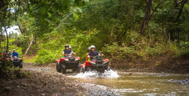 All Terrain Motorsports
Internal roads and several forest trails that are perfect for experiencing the property from an ATV or UTV. These exciting machines handle the wide variety of terrain.
Rock Crawling & Rock Bouncing
Areas of the property afford a topographic opportunity for the Extreme Off-Road adventurist to enjoy the increasingly popular Motorsport of Rock Crawling and Rock Bouncing.
 Dirt bikes and Motorcross can also be a lot of fun and they come in all sizes and horsepower to fit anyone who enjoys being on two wheels and sometimes in the air.
 Hunting is a first-class experience. White tail deer, black bear, red/gray fox, bobcat, wild turkey, grouse, duck, squirrel, raccoon, fox and rabbit make up the resident wildlife population. It is hard to find a property that has a better mix of wildlife.
Nearby Recreation – The Heartland’s Ten Rivers and Six Lakes
- The rivers include the Elk, Hughes, Little Kanawha, Gauley, Cherry, Buckhannon, Tygart, Monongahela, and Pocatalico Rivers
- The lakes include Burnsville, Sutton, Stonewall Jackson, Summit, Summersville, and Stonecoal
- The rivers and lakes are about anywhere from ten minutes to two hours drive from the property
- Great fishing is found in the rivers and lakes with small and large mouth bass, crappie, catfish, muskie, walleye, pike and bluegill present in good numbers.
FOREST/TIMBER RESOURCES
The property consists of 312 acres +/- with about 300 being in timber. The trees in the forest consist of ages classes across a broad spectrum. The age classes present anywhere from 2 years old to 150 years old. Much of the timber was selectively thinned about 25 years ago. The distinguishing features of Burnsville Lake Forest’s timber resource is its unusually high hardwood pre-commercial and pole stocking with a solid basal area per acre. This stocking is well above average for the region. This well managed timber resource can provide a great deal of flexibility to the next ownership in terms of potential harvest revenue and can be managed to provide cash flow opportunities to offset holding costs and long-term asset appreciation.
Capital Timber Value and a forest-wide timber inventory have not been established by the owner at this time. The next harvest cycle of mature timber is estimated to be 15 to 20 years.
The forest’s predominately well-drained upland terrain has led to a resource dominated by hardwood species. Overall, the species composition is highly desirable and favors Appalachian hardwood types, consisting primarily of White Oak/Chestnut Oak, Red Oak Group, Poplar/Cucumber/Basswood, Sugar Maple/Soft Maple and a host of associate species.
Stocking, Stem Quality, and Forest Structure: Forest-wide, most stands are fully stocked, providing the next ownership with a great deal of flexibility in shaping their own silvicultual legacy. Stem quality forest-wide can be considered excellent with the forest containing an abundant future veneer source.
The BLF forest’s timber component has been professionally managed for many years. The predominant timber stand of the forest contains 10–50-year-old stems ranging in size of 2-16” dbh with a 20-year-old new forest growing among the older trees.
The second distinct stand is comprised of 50+ year old trees that are mature forest stands scattered throughout the boundary along the creeks and streams.
Some trees are well over 150 years old and classify as “Heritage Trees”. These amazing trees have withstood the test of time and lend an air of grace and permanency to the property.
The forest is healthy and there are no signs of pest infestations of Gypsy Moth. The Emerald Ash Borer and the Hemlock Wooly Adelgid are present, and the majority of the Ash and Hemlock trees are severely stressed and will die out over the next decade. Thankfully, there have been no forest fires in recent memory.
WILDLIFE
Years of wildlife management practices have created the ideal wildlife preserve. Early on, management goals promoted overall wildlife health, facilitated the harvest of game, developed wildlife viewing areas, increased carrying capacity, and increased species diversity.
The miles of ephemeral stream and along with a varied topography is a major contributor to the local ecosystem richness and diversity for both plants and animals. The BLF property’s associated streams, and feeders, create a water supported community with a wide variety of wildlife. Some of the margins of the creeks are fringed by wetlands. These wetlands support the aquatic food web, provide shelter for wildlife, and stabilize the streambanks. Some of the plant life associated with the wetland includes rushes, sedges, cattails, duckweed, skunk cabbage, and algae.
There are many animals that live year-round, and at other times, in the water and around the edges of the area’s lakes, rivers, ponds, creeks and streams. These include raccoons, opossums, blue herons, Canada geese, wood ducks, mallards, minnows, native fish, turtles, salamanders, newts, crayfish, muskrats, bull frogs, eagles, hawks and redwing blackbirds.
There is the insect and microscopic world including butterflies, dragonflies, pond skaters, water beetles, damselflies, tadpoles and various insect larvae.
The diverse tree species, coupled with the abundant water supply, create the perfect wildlife habitat. The miles of “edge effect” created between the access roads, forest trails, hollows, ridges, and rock outcrops benefit all the resident wildlife. Bald eagles, white tail deer, black bear, wild turkey, squirrel, rabbit, bobcat, raccoon, fox and many species of songbirds, owls and raptors make up the resident wildlife population.
The hardwood forest provides an essential nutrient source and produces tons of hard mast including acorns, hickory nuts, beech nuts and black walnuts. Soft mast includes stag horn sumac, black cherry, tulip poplar seeds, maple seeds, autumn olive berries, and blackberries.
BUTTERFLIES

The property is an exceptional habitat for all butterflies, especially the Monarch. The monarch is highly dependent on the milkweed plant and will always return to areas rich in milkweed to lay their eggs upon the plant. The milkweed they feed on as caterpillars is actually a poisonous toxin and is stored in their bodies. This is what makes the monarch butterfly taste so terrible to predators.
Of course, other butterflies visit the property, including the eastern tiger and spicebush swallowtails, silver-spotted skipper, and a variety of sulphurs and whites.
One other interesting insect to visit the property is the Black Saddlebag Dragonfly, a regular guest of the creeks and wetlands with all the frogs, salamanders, crawdads and turtles.
CARBON SEQUESTRATION
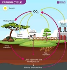 The 312 +/- acres is a tremendous producer of Oxygen and sequester of Carbon Dioxide. Carbon Sequestration is the act of processing carbon dioxide through sinks and stores and releasing them into the atmosphere as oxygen. The vigorously growing forest is sequestering thousands of tons of Carbon Dioxide each per year and producing tons and tons of life-giving Oxygen.
This natural process allows the owner (and family/friends) the opportunity to potentially enjoy a carbon neutral footprint.
The leasing of “Carbon Credits” to environmental mitigation companies is a rapidly emerging financial opportunity for the property owner to receive income without placing any burden on the land. The leases can be for as little as one year.
FOREST FARMING

The most common crops are medicinal herbs and mushrooms. Other crops that can be produced include shade-loving native ornamentals, moss, fruit, nuts, other food crops, and decorative materials for crafts. These crops are often referred to as special forest products.
Here are some specific examples of crops:
- Medicinal herbs: Ginseng, goldenseal, black cohosh, bloodroot, passionflower, and mayapple
- Mushrooms: Shiitake and oyster mushrooms
- Native ornamentals: Rhododendrons and dogwood
- Moss: Log or sheet moss
- Fruit: Pawpaws, currants, elderberries, and lowbush blueberries
- Nuts: Black walnuts, hazelnuts, hickory nuts, and beechnuts
- Other food crops: Ramps (wild leeks), maple syrup, and honey
- Plants used for decorative purposes, dyes, and crafts: Galax, princess pine, white oak, pussy willow branches in the spring, holly, bittersweet, and bloodroot and ground pine (Lycopodium)
PERMACULTURE FARMING

The three core tenets of permaculture are:
- Care for the earth: Provision for all life systems to continue and multiply. This is the first principle, because without a healthy earth, humans cannot flourish.
- Care for the people: Provision for people to access those resources necessary for their existence
- Setting limits to population and consumption: By governing our own needs, we can set resources aside to further the above principles. This includes returning waste back into the system to recycle into usefulness. The third ethic is sometimes referred to as Fair Share, which reflects that each of us should take no more than what we need before we reinvest the surplus.
Permaculture design emphasizes patterns of landscape, function, and species assemblies. It determines where these elements should be placed so they can provide maximum benefit to the local environment. Permaculture maximizes useful connections between components and synergy of the final design. The focus of permaculture, therefore, is not on each separate element, but rather on the relationships created among elements by the way they are placed together; the whole becomes greater than the sum of its parts. Permaculture design therefore seeks to minimize waste, human labor, and energy input by building systems, and maximizes benefits between design elements to achieve a high level of synergy. Permaculture designs evolve over time by taking into account these relationships and elements and can evolve into extremely complex systems that produce a high density of food and materials with minimal input.
The design principles, which are the conceptual foundation of permaculture, were derived from the science of systems ecology and study of pre-industrial examples of sustainable land use. Permaculture draws from several disciplines including organic farming, agroforestry, integrated farming, sustainable development, and applied ecology. Permaculture has been applied most to the design of housing and landscaping, integrating techniques such as agroforestry, natural building, and rainwater harvesting within the context of permaculture design principles and theory.
RIPARIAN ZONES

In earlier times, before the environmental and societal values of riparian zones (RZ’s) were discovered, the RZ was commonly called a “swamp”. These enchanting areas are biologically rich and wildlife diverse, being akin to the world’s largest swamps found in the Florida Everglades and the Amazon River Basin. The mighty RZ works to provide “ecosystem services”—non-monetary benefits like clean water, clean air, carbon sequestration, and recreation for everyone.
These areas are the best of both worlds. Here you can watch for deer, squirrels, raccoon, and turkey while exploring for butterflies, turtles, frogs, crawdads, songbirds, salamanders, newts, and a host of other aquatic invertebrates, migratory birds, reptiles, and amphibians.
The RZ’s are a very productive part of the environment, more productive of vegetation, in fact, than some agricultural soils. This vegetation serves important purposes. It shelters and feeds many wildlife species that cannot survive elsewhere. Almost 35 percent of all rare and endangered species depend, in some way, on RZ’s. More common riparian zone species provide enjoyment to many by serving educational, research and recreational needs. Waterfowl and many furbearers such as beaver, mink and muskrat provide both consumptive and no consumptive recreation and are dependent on the zones. Many fringe RZ’s provide the food that young fish need to survive. By slowing the flow of water, RZ’s help keep banks from eroding and they trap and settle suspended silt before it smothers fish eggs and covers the insects and other animals that fish eat.
Riparian zones add visual diversity and offer an opportunity to see many different plant and wildlife species seen nowhere else on the property.
THE “FLATWOODS MONSTER”
 By Ted Fauster, Contributing Editor -August 1, 2024
The “Flatwoods Monster” was alleged to have been discovered near a wrecked flying saucer in central W.Va. (Illustration by David Sibray)
SUTTON, W.Va. — Many West Virginians have heard of a mysterious incident in Braxton County that involved a possibly celestial creature known as the Flatwoods Monster.
It was alleged to have appeared in the darkened woods behind the local grade school in 1952, only moments after a “flying saucer” had been sighted scooting over the trees.
Though the encounter was brief, it earned national headlines and has since puzzled cryptid enthusiasts and monster hunters worldwide. A museum has even been established to explore the legend.
Kathleen May and her two sons were present that day, and they recounted the event often over the years. But was what they saw really an alien creature?
Andrew Smith, executive director of the Braxton County Convention & Visitors Bureau (and curator of the Flatwoods Monster Museum), says he believes May.
According to legend, the Flatwoods Monster crash-landed in a spaceship near Flatwoods in central West Virginia in 1952.
“I know Kathleen May very well,” Smith stated. “She’s not one to make up things, and I believe her.”
May was present, along with her cousin Gene Lemon and a small group of boys, including her sons Ed and Freddy May, who had gone hunting for an object they saw float across the tops of the trees—something that they said resembled a saucer!
“The witnesses described a floating apparition with a big red face and a larger spade-shape behind it. It had a long, thin body,” Smith explained, noting that the creature appeared to possibly change color from black to green or to be colorless.
“In my mind, they can all be accurate descriptions.”
Its body was also possibly metallic. “Depending on the light, you could either get black or green or maybe no color at all—almost like it was camouflaged.”
May also described what could have been pleats on the creature’s lower half, somewhat like a skirt, although Smith suspects this might have been metal strips.
“It almost sounded like folded metal or pipes,” Smith said. “Possibly, this was some propulsion system, but now we’re getting close to guessing.”
The boys quickly turned and ran back down the hill when it began moving toward them.
This was the only sighting of the Flatwoods Monster, now known as the Green Monster, the Braxton County Phantom, and the Phantom of Flatwoods.

The weirdness and mismatched description, coupled with the fact that the entity was only briefly seen hovering over the ground with limited movement, might suggest something more sinister: Was the sighting the result of a prank? Was it nothing more than an elaborate hoax?
Smith likes to believe otherwise. “I was friends with Freddy May,” he said. “If he says that’s what his mom said, then that’s all the evidence I need to believe her.”
But what if it was something else? What if it was a dummy tied to a clothesline with someone pulling it along?
“Well, then you’d also have to tie that in with some sort of aerial phenomenon,” Smith countered.
The sighting of the saucer before the entity’s arrival was not observed only locally, which adds logical credence to the tale. Reports of the flying object came in from other regions.
“I’m sure it’s possible,” Smith added. I’m sure there have been bigger coincidences than that.”
The History Channel reports, “In the days following the initial sighting of the Flatwoods Monster, the story gained national attention, with newspaper and radio reports spreading the news.”
Despite this, there were no other confirmed sightings of the creature around the same time, and no similar reports exist.
Precisely what the Flatwoods Monster was will remain a mystery, lost to the receding folds of time until it chooses to grace mankind with another appearance.
The Flatwoods Monster Museum is located at 208 Main Street, Sutton, WV 26601. It is open from 9 a.m. to 5 p.m. on weekdays and 10 a.m. to 4 p.m. on weekends. Admission is free.
This article was written by Ted Fauster, contributing editor, and David Sibray, editor WV Explorer, historian and Foxfire Realty Agent.
DIRECTIONS
From I-79 Flatwoods Exit 67: 13.4 miles +/- (approximately 25 minutes)
At the end of the exit ramps, turn toward US 19 North getting into the left turn lane, go short distance, turn left onto US 19 North, travel US 19 North for 11 miles; after crossing the headwaters of Burnsville Lake, turn left onto Millstone Run Road Rt. 19/12; travel 2.4 miles; turn left onto Little Knawl Road Rt 4/4; the camper field is on the right.
REGIONAL INFORMATION
STATE INFORMATION
- State of West Virginia
- West Virginia Explorer
- West Virginia Government
- West Virginia State Parks
- West Virginia Tourism
- Wonderful West Virginia Magazine
- WV Department of Natural Resources
- Virginia – Commonwealth of Virginia
- Virginia is for Lovers
- Virginia Museum of History & Culture
- Virginia Museum of Natural History
- Virginia National Park Service
- Virginia Recreation
- Virginia State Parks

Contact Foxfire
304.645.7674
Gallery


")
")


