CAMP MAHONEGON SCOUT RESERVATION
Sold!

| Price: | |
|---|---|
| $1,300,000 | |
| ID: | 707 |
| Acres: | 417 +/- |
| Address: | |
Agent Contact:
Richard Grist, 304.645.7674

MAPS & DOCUMENTS-CLICK LINKS TO VIEW
CAMP MAHONEGON
The 417-acre Camp Mahonegon (Maa-haun-uh-gone) includes 17 well-maintained structures including a large dining hall/commercial kitchen, cabins, trading post, Adirondack shelters and camping sites. Nearly 2 miles of direct frontage on the Middle Fork River provides a stunning focal point and is the anchor for all other activities. There is estimated to be $715,000 in ready to harvest timber.
HIGHLIGHTS
- 417+/- multi-use acres located in rural Upshur-Barbour Counties on the Middle Fork River
- Camp Mahonegon is pronounced (Maa-haun-uh-gone)
- $715,000 in ready to harvest timber managed by professional foresters
- The spectacular forest is a registered American Tree Farm
- Camp was officially founded in 1948 – Informal scouting activity dates to 1914
- 17 well maintained structural improvements with 16,292 square feet under roof
- 175’ long steel swinging bridge for walking across the Middle Fork River
- 2 miles of frontage on the Middle Fork River complete with portable boat dock, swinging bridge and excellent fishing
- River is stocked with trout February through May (Golden, Brook, Rainbow, Brown, and the awesome WV Centennial Rainbow)
- Multiple uses for Residential/Recreational/Timber Management/Land Conservation
- Topography ranges from flat bottomland fields to heavily forested hillsides
- Extensive infrastructure improvements: public water, natural gas, internet, private septic system, electric, landline phone, cell coverage, 3 drilled water wells
- Miles of improved access roads and forest trails provide access to nearly every corner of the property
- The exceptional forest includes Oak, Beech, Sugar Maple, Soft Maple, Black Walnut, Hickory, Sassafras & Tulip Poplar
- The 900,000-acre Monongahela National Forest and several State Parks are nearby
- Area enjoys low taxes, low population density
- 20 minutes to two county seats -Elkins and Buckhannon, with all city amenities
- Commercially – operable ground supporting farming, forestry, recreation
- Easily dividable into smaller tracts for flexible ownership facilitated by no county zoning
- Mountain streams feed the 35 mile-long Middle Fork River surrounded by bottomland farm fields and dense forest
- Cabins, camping areas, open shelters, large dining hall, commercial kitchen, ranger residence, all designed for easy living and enjoying nature, family and friends
- Jet air service daily to regional hubs are an easy 1-2 hour’s drive by interstate
- Easy access to Interstates I-79, I-77, US 119, US 33, US 250, US 219
- Rock outcroppings for bouldering and free climbing
- Water loving wildlife include fish, otter, beaver, mink, blue heron, wood duck, mallard, raccoon, Canada geese, turtle, bullfrog, crayfish, muskrat, newt, and salamander
- Resident fur bearing wildlife include rabbit, deer, black bear, bobcat, squirrel, chipmunk
- Winged wildlife includes bald eagles, wild turkeys, grouse, neo-tropical songbirds, woodpeckers, hawks, owls, ravens, and a large variety of other small birds
- The darkest of night skies with little or no light pollution for star gazing and planet observation
- 2 native trout streams directly across the river, Hell Run and Devil Run, feed the river
- At the corner of three counties – Upshur, Barbour and Randolph
- Elevations run from 1820’ to 2203’
- Some very ancient 200 + year old “Heritage Trees” scattered about the forest
- Piles of field stone about the old field edges gathered by early mountaineers
- Long views of distant mountains across the river and from the high ridges
- Easy drive to Snowshoe Resort, Morgantown, Charleston, Pittsburgh, Washington DC
- Flat to rolling to steep topography with seasonal branches, benches and verticals create an interesting natural setting
- Open areas suitable for grazing of domestic livestock including dairy cows, sheep, chickens, geese, goats, rabbits, turkey and poultry
- Self-sustaining lifestyle off the grid or “Permaculture” is entirely possible
- Small areas of wetlands provide a unique animal and plant habitat
- Wilderness area used for the observation of natural ecosystems and its cycles
- Property well suited to produce honey, maple syrup, wild berries, row crops, fruit and vegetables
OVERVIEW
In 1948, enthusiastic Boy Scouts made their first official excursion to the newly formed “Camp Mahonegon”. Interestingly, scouts had been camping on the property since 1914 as invited guests of the Avington family. Since then, thousands of Cub Scouts and Boy Scouts, spanning multiple generations, have taken part in both summer and winter sessions at the camp. The scouts complete requirements for numerous outdoor-related merit badges, build fires, set up tents, learn archery skills, swim, fish and canoe on the Middle Fork River. The trumpet’s call signaled it was time to wake up, head to the dining hall, attend a camp meeting or time to bed down for the evening.
The 417-acre Camp Mahonegon includes 17 well-maintain structures including a large dining hall/commercial kitchen, cabins, trading post, and camping sites. Nearly 2 miles of direct frontage on the Middle Fork River provides a stunning focal point and is the anchor for all other activities.
Camp Mahonegon lies in the heart of the Allegheny Mountains in the unspoiled east-central region of West Virginia. The free flowing river is surrounded by 417 acres of bottomland fields and densely forested woodland with a few scattered wildlife and camping openings. The abundance of water is a major contributor to the local ecosystem richness and diversity for both plants and animals.
The surrounding Allegheny Mountains provide a flawless backdrop for this 417-acre high elevation recreational-residential-timber investment property. Miles of forest trails offer hiking, horseback riding and ATV/off-roading adventure. Beyond the sheer beauty of the water, the river offers the soft recreation activities of swimming, paddle sports, ice skating, windsurfing and of course fishing for bass, bluegill, catfish and crappie.
It is very common to see deer and turkey grazing in the shore-side forest while ducks and geese paddle by on the water. There is a good chance bald eagles, red tail hawks or blue herons will make a morning visit.
LEGEND OF MAHONEGON – CAMP NAME
Pronounced (Maa-haun-uh-gone)
The Legend of Mahonegon has been told and retold countless times at Eagle Rock and is a tradition as old as the camp.
The mountainous land of deep forest and glistening streams called the Alleghenies, was inhabited by the Native American Indian – Delaware Nation. The wisest and most honored was the mighty chieftain “Buckongehannon”, who was known throughout the land for his cheerfulness of spirit and willingness to be of service. It was Buckongehannon’s belief that all men should live in harmony. At the chief’s side stood the bravest of the Delaware nation, “Mahonegon-Running Wind”, son of Buckongehannon.
See gold colored box above labeled Maps and Documents for complete LEGEND
FOREST/TIMBER RESOURCES
Camp Mahonegon’s 400-acre spectacular forest is a well-managed and is a registered American Tree Farm. The timber resource is comprised of high-quality Red Oak, White Oak, Maple, Hickory and Poplar. This well managed forest will provide a great deal of flexibility to the next ownership in terms of potential harvest revenue and can be managed to provide cash flow opportunities to offset holding cost and long-term asset appreciation.
Commercial Value See gold colored box above labeled Maps and Documents for complete timber inventory
A 2018 forest wide inventory conducted by a registered, professional forester indicates there is an estimated $715,000 in merchantable timber and pulpwood. The inventory shows there to be over 2.2 Million Board Feet of standing timber and some 15,000 tons of pulpwood.
The forest’s predominately well-drained upland terrain has led to a resource dominated by natural hardwood species. Overall, the species composition is highly desirable and favors yellow poplar, hickory, red oak, white oak and maple.
Stocking and Forest Structure:
- Black Cherry – 2 %
- Sugar Maple – 3%
- Poplar/Cucumber/Basswood – 20%
- Red Oak Group – 15%
- White Oak/Chestnut Oak – 37%
- Soft Maple – 15%
- Hickory – 5%
- Beech – 2%
- A host of other species 1% (birch, black gum, sassafras, wahoo, buckeye, locust)
Forest-wide, most stands are fully stocked to overstocked, providing the next ownership with a great deal of flexibility in shaping their own silvicultural legacy. Stem quality forest-wide can be considered excellent with the forest containing an abundant current and future sawlog source.
The forest’s timber component has been well managed over the years. Portions of the forest were thinned as prudent forest management called for. The forest could benefit from an immediate marked thinning which would generate considerable income and improve forest health. The forest has matured into higher-value sawtimber diameter classes with an abundant growing stock already in place for the future.
Diameters are well represented across the commercial spectrum with a notable mature size class, as well as abundant pole size timber and growing stock.
A few “Heritage Trees” are scattered throughout the forest. These ancient trees, some 150+ years old, have withstood the test of time, weathering ice, wind, lightning strikes and fire.
The forest is healthy and there are no current signs gypsy moth. The Emerald Ash Borer is present and it is anticipated that the Ash component will be in decline over the next decade. There have been no forest fires in the recent memory. The Hemlock Wooly Adelgid is present and the Eastern Hemlock species is in decline.
The forest floor is home to several types of mushrooms, medicinal plants, ferns and cool green mosses. One could spend a lifetime getting to know this inviting environ.
Beechnuts, Hickory nuts, sweet White Oak and Red Oak Acorns provide a sustainable food source for the squirrels, chipmunks, whitetail deer and wild turkey that live in abundance in the forest.
Not surprising, the trees, shrubs and meadow grasses are highly productive in producing tons and tons of oxygen while at the same time eliminating huge amounts of Carbon Dioxide; Nature’s way of reducing our Carbon Footprint.
THE MIDDLE FORK RIVER
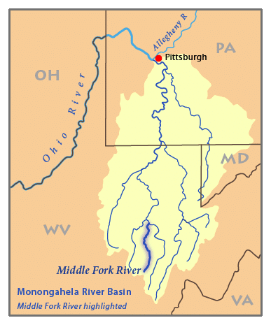 The Middle Fork River provides a stunning main focal point framed by the backdrop of the fields, forest and mountains. The river is a major contributor to local ecosystem richness and diversity for both plants and animals.
The WV Department of Natural Resources stocks trout in the Middle River in three different locations along its 35-mile length, including a 3 mile stretch from the camp upriver to the community of Ellamore. The stocking takes place once a month from February through May and includes the entire 2 miles river frontage of the property. Deep holes, shallows, huge boulders, still water and rapids make for an exceptional fishing experience.
The river and its surrounding aquatic plant life create a water supported community with a wide variety of wildlife. Some of the margin of the river is fringed by wetlands, and these wetlands support the aquatic food web, provide shelter for wildlife, and stabilize the shore of the river. The plant life associated with the wetland includes rushes, sedges, cattails, duckweed and algae.
There are many animals that live in the water and around the edges of the river including beaver, otters, mink, raccoons, opossums, blue herons, Canada geese, wood ducks, mallards, minnows, stocked fish, turtles, salamanders, newts, crayfish, muskrat, bull frogs, and redwing blackbirds.
The Middle Fork River is a 35-mile-long tributary of the Tygart Valley River in north-central West Virginia. The river flows the Tygart Valley, Monongahela and Ohio rivers, it is part of the watershed of the Mississippi River, draining an area of 152 square miles on the easternmost part of the unglaciated portion of the Allegheny Plateau.
The river flows generally northwardly and its course defines part of the boundary between Randolph and Upshur counties, and then between Upshur and Barbour counties, before flowing into southern Barbour County, where it joins the Tygart Valley River.
For most of its course, the Middle Fork forms whitewater rapids of Class I to Class IV and is unique in that it flows in northerly direction.
RECREATION AT CAMP MAHONEGON
Camp Mahonegon offers unparalleled recreational opportunities. Numerous soft recreational activities are anchored by the Middle Fork River. The camp’s 417 acres consist of beautiful river frontage, fields and forest which provides the foundation for all that is Camp Mahonegon.
Camping & Year-round living: The property is ready to go and offers seasonal camping or year-round living opportunities. There are 17 well-maintained improvements including a dining hall with a commercial kitchen, 3 cabins, Ranger’s cabin, Adirondack camping shelters, tent camping areas, storage buildings etc. Heating for the buildings, cooking and hot water is provided by natural gas.
Nature viewing is first in line of the soft recreational activities. Attentive wildlife management has been geared not to just game animals. Equal consideration has been extended to increasing the numbers and diversity of species including neo-tropical songbirds, butterflies, turtles, frogs, rabbits, chipmunks, dragonflies, owls, hawks. The river and its attentive wetlands provides habitat for wood duck, geese and mallards. White tail deer, black bear, red/gray fox, bobcat, wild turkey, grouse, squirrel, raccoon, fox, opossum and rabbit make up the resident wildlife population. It is hard to find a property that has a better mix of wildlife as there has been professional wildlife management for many years.
Stargazing-Planet Observation: Complete darkness can be still be found on most of the property, thereby affording the opportunity to view the night sky in all its brilliant wonder.
Water-sports enthusiasts will find the crystal-clear river ideal for: Swimming, boating, kayaking, tubing, snorkeling, paddle boarding and wind-surfing. Fishing is outstanding for bass, bluegill, crappie, and catfish. Trout are stocked along the property’s two mile stretch from February through May, including Brown, Rainbow, Brook and WV Centenial Golden Rainbow). Two native trout streams are directly across river from the camp (Hell Run and Devil Run).
Shooting-sports devotees find all the land and privacy needed to enjoy:
- Paintball-Airsoft-Laser Tag-Archery tag
- Shotgun sport shooting including Skeet, Trap, Double Trap and Sporting Clays
- Rifle & Handgun shooting: bullseye, silhouette, western, bench rest, long-range, fast draw
- Archery and Crossbow competition shooting
- Plain ole’ plinking: 22 single shot rifle and a few tin cans make a fun day
All Terrain Motorsports: Camp Mahonegon has miles of internal roads and forest trails that are perfect for experiencing the property from an ATV or UTV. These exciting machines handle the wide variety of Camp Mahonegon’s terrain. The riders can go from down along the river, wind through the pine and hardwood forest, across the fields and up to the highest ridges.
Dirt bikes can also be a lot of fun and they come in all sizes and horsepower to fit anyone who enjoys being on two wheels (hopefully).
Mountain biking, horseback riding and hiking: The same trails used for Motorsports can also be used for mountain biking or horseback riding. The trails are designed to be on gentle grades but some trails coming off the ridges offer a more challenging climb.
WILDLIFE MANAGEMENT
70 years of progressive wildlife management have created the ideal wildlife preserve. Early on, management goals intended to promote overall wildlife health, develop wildlife viewing areas, increase carrying capacity, and increase species diversity.
The Middle Fork River is a major contributor to the local ecosystem richness and diversity for both plants and animals. The river and its surrounding aquatic plant life create a water supported community with a wide variety of wildlife. Some of the margin of the river is fringed by wetlands, and these wetlands support the aquatic food web, provide shelter for wildlife, and stabilize the shore of the river. The plant life associated with the wetland includes rushes, sedges, cattails, duckweed and algae.
There are many animals that live in the water and around the edges of the river including beaver, otters, mink, raccoons, opossums, blue herons, Canada geese, wood ducks, mallards, minnows, stocked fish, turtles, salamanders, newts, crayfish, muskrat, bull frogs, and redwing blackbirds.
There is the insect and microscopic world including butterflies, dragonflies, pond skaters, water beetles, damselflies, tadpoles and various insect larve.
Several sites throughout the property have served as permanent food plots. These areas include small woodland openings, riverbank buffers, forest management trails, interior access roads, thinned forest areas, riparian zones, naturally regenerated hardwood areas, and field corners.
The property has a mixture of mature hardwood forest, grassed recreational areas, and small regenerated forest areas. All this, coupled with the abundant water supply from the river and creeks create the perfect wildlife habitat. The miles of “edge effect” created between river, fields, trails and forest is the textbook habitat for all the resident wildlife. The edges create a miles long wildlife food plot. Bald eagle, white tail deer, black bear, wild turkey, squirrel, rabbit, bobcat, raccoon, fox and many species of songbirds, owls and raptors make up the resident wildlife population.
The hardwood forest provides the essential nutrient source and produces tons of hard mast including acorns, hickory nuts, beech nuts and black walnuts. Soft mast includes stag horn sumac, black cherry, tulip poplar seeds, maple seeds, autumn olive berries and blackberries.
THE DYNAMIC WETLAND
In earlier times, before the environmental and societal value of wetlands was discovered, Camp Mahonegon’s tiny, buy dynamic wetland was commonly called a “swamp”. This enchanting area is biologically rich and wildlife diverse, being akin to the world’s largest swamps found in the Florida Everglades and the Amazon River Basin. This small, but mighty wetland works to provide “ecosystem services”—non-monetary benefits like clean water, clean air, carbon sequestration, hunting, and recreation for everyone young and old.
The wetlands are the best of both worlds. They provide a place to watch for deer, squirrels, raccoon, and turkey while exploring for butterflies, turtles, frogs, crawdads, songbirds, salamanders, newts, and a host of other aquatic invertebrates, migratory birds, reptiles, and amphibians.
Wetlands are a very productive part of our environment; more productive of vegetation, in fact, than some agricultural soils. This vegetation serves important purposes. It shelters and feeds many wildlife species that cannot survive elsewhere. Almost 35 percent of all rare and endangered species depend, in some way, on wetlands. More common wetland species provide enjoyment to many by serving educational, research and recreational needs. Waterfowl and many furbearers such as beaver, mink and muskrat provide both consumptive and no consumptive recreation and are dependent on wetlands. Many fringe wetlands provide the food that young fish need to survive. By slowing the flow of water, wetlands help keep banks from eroding and they trap and settle suspended silt before it smothers fish eggs and covers the insects and other animals that fish eat.
Wetlands add visual diversity to everyone’s lives. The mile long river-side trail offers an opportunity to see many different plant and wildlife species seen nowhere else on the property.
SELF-SUSTAINING LIFE OFF THE GRID
Just like 200 years ago, when the first mountaineers settled the area, the property would be self-sustaining in times of necessity – even without electricity.
- Fresh water for drinking and cooking would come from springs and the drilled water wells (hand drawing water from the wells using a cylinder well bucket).
- The river could provide hydro-powered electricity
- The river and forest would provide fresh food (fish, deer, and turkey).
- The agricultural land would be used to raise livestock, vegetable gardens, berry patches, fruit orchards, and row crops of corn, oats and barley.
- Beehives would provide honey and beeswax for candles.
- The vast forest would provide firewood for heating and cooking, lumber for building, maple syrup and pounds of nuts (walnuts, beechnuts and hickory nuts).
WATER RESOURCES
- The property has an abundance of water resources, anchored by the 2 miles of frontage on the Middle River.
- Two separate dashed blueline streams flow for 4/10 mile each through the property. Additional ephemeral streams flow during rain events and snow melt.
- There are drilled water wells and some wet weather springs scattered about on the property.
- Public water is available onsite.
GEOLOGY
The bedrock of the Alleghenies is mostly sandstone and metamorphosed sandstone, quartzite, which is extremely resistant to weathering. Prominent beds of resistant conglomerate can be found in some areas, such as the Dolly Sods. When it weathers, it leaves behind a pure white quartzite gravel. The rock layers of the Alleghenies were formed during the Appalachian orogeny.
Because of intense freeze-thaw cycles in the higher Alleghenies, there is little native bedrock exposed in most areas. The ground surface usually rests on a massive jumble of sandstone rocks, with air space between them, that are gradually moving down-slope. The crest of the Allegheny Front is an exception, where high bluffs are often exposed.
Mineral springs in the High Alleghenies attracted Native Americans and 18th century white settlers and provided a modest incentive to the local economy. The spas developing around these geological features include celebrated resorts.
SWINGING BRIDGE
The iconic Swinging Bridge was built in 1950 to provide scouts and leaders pedestrian access to the main camp across the Middle Fork River. The historic bridge is a thrill to traverse as it does “swing, sway and bounce” on the walk across the river. Before the bridge was built, rafts were used to transport anyone and anything across the river. The 200 foot long – 3 story high, metal bridge is supported with large steel cables and is newly floored with slip resistant industrial metal grates.
The bridge is a popular place for scouts and local’s to fish from, as evidenced from the amount of “tackle” hanging from a nearby utility line.
LOCATION
Google Coordinates: 38.951480°(N), -80.075505°(W)
Address: 3017 Boy Scout Camp Road, Ellamore, WV 26267
Elevation Range: 1820 ft. to 2203 ft. +/-
MINERAL RESOURCES
West Virginia is one of the states in the US that has two ownership titles, those being SURFACE RIGHTS and MINERAL RIGHTS. The Coal, Oil, and Gas of the properties have been reserved in prior deeds of record.
BOUNDARIES AND SURVEY
The property is comprised of several tracts. There has been a map prepared showing the boundary containing those several tracts. The property is being sold by the boundaries and not by the acre.
UTILITIES
Water: Public Water and 3 drilled water wells
Sewer: Private Septic
Electricity: Onsite
Natural Gas: Onsite
Telephone: Onsite
Internet: Onsite
Cellular: Good in most places with 4G
ACCESS/FRONTAGE
Boy Scout Camp Road RT 10/19 leads into the property, providing access to the public road system. Several miles of internal roads and trails service the property providing access to nearly every part of the property.
ZONING
No zoning department or zoning information is shown on the government websites for either Barbour or Upshur Counties. However, all prospective buyers should consult the County Government and also the Health Department for details regarding zoning, building codes, and installation of water wells and septic systems.
PROPERTY TYPE/USE SUMMARY
The large tract has about 16 acres of open area comprising the main camp and the balance of the tract, about 396 acres, is comprised of forestland. The small tract has about 2.3 acres of open with the cabin and about 3 acres of forestland.
(This is an estimation of current property use as determined from aerial photography. It is made subject to the estimation of property boundaries and any errors in the interpretation of land use type from the aerial photography utilized.)
ITEMS NOT CONVEYING
Signage, Scout memorabilia and other personal property do not convey.
DEED AND TAX INFORMATION
Deeds Information:
DB 121 Pgs. 265, 268, 271, 273, 275, and 278
Upshur County, West Virginia
DB 117 Pg. 253, Barbour County, West Virginia
Acreage: 417 acres +/-
Real Estate Tax ID/Acreage/Taxes:
Upshur County (49), West Virginia
Union District (5)
Tax Map 9H Parcels 7,8,10,19,20,21,22,23, and 36
Barbour County (1), West Virginia
Valley District (11)
Tax Map 18 Parcel 8, Class 3
2019 Total Real Estate Taxes: Exempt
RESIDENCES AND BUILDINGS
The property is improved with 17 structures that create a gross area of 16,292 square feet. The buildings range from a small fuel storage building to a large dining hall and the ranger’s cabin.
The records indicate that the camp was originally constructed in the late 1950s up to the late 1960s. The structures are all wood frame with wood siding except for the main dining hall which has metal siding. The dining hall has metal roofing, but all of the other structures have fiberglass or asphalt shingle roofing of varying ages and condition. Plumbing dates 1960s to 1980s. Many of the buildings have identical construction characteristics even though they may vary in use. The buildings are in good condition.
Other than the buildings, there is a significant amount of infrastructure associated with the property. There is a short asphalt paved entrance road off of Boy Scout Camp Road, then a series of gravel and dirt based roads and trails throughout the camp. The property’s onsite utilities include gas, electric and city water. It relies on either an old style lagoon or septic systems to handle sanitary waste from the various buildings.
There is a swinging bridge which crosses the Middle Fork River from the main camp to the Ranger Cabin. There is also a wooden waist-high enclosure used for dodge ball games. There are a number of campsites, fire pits and fire rings.
STRUCTURES AND SIZES
Ranger’s Cabin 1,232 SF
Dining Hall 6,100 SF
Pavillion (open) 2,160 SF
Trading Post 1,650 SF
Craft Building 1,260 SF
Health Lodge 720 SF
Winter Lodge 684 SF
Shower House 750 SF
Maintenance Building 1,152 SF
Fuel Building 96 SF
Storage Units 384 SF
Adirondack Shelters (6) (Semi-open) 154 SF Each
Ranger’s Cabin
The Ranger’s Cabin was built in 1960. The Cabin is constructed with a block foundation, wood siding, and shingle roof. Replacement windows have been installed. The overall dimensions of this structure are 32’x 25’. There is a small 8’x12’ front covered porch. The roof is in fair condition.
Dining Hall
The dining hall is a wood-frame structure with a concrete floor slab and metal siding. The indoor segments include a commercial grade kitchen, storage rooms, a walk-in cooler and a half bath. The large dining area measures 30’x 82’. The large kitchen is 30’x 40’. There is a covered porch on the front measuring 10’x82’ and a covered porch off the kitchen measuring 10’x 25’. This structure seats 175, has a large stone fireplace, and is heated and cooled with suspended units.
Shower House/Health Lodge/Craft Hut
The shower house is a block building with wood siding and a shingle roof. It is a 50’x15’ structure divided into Men’s and Women’s units.
The Health Lodge is an 18’x36’ building with a refrigerator and a bathroom with toilet, sink and shower. It is served with electric and gas. It is heated and is estimated to sleep 12.
The Craft Hut is served with electricity but has no heat. It measures an overall 42’x 14’. Part of this structure is a pavilion on concrete pad which measure 14’x18’. This building sleeps 8.
Winter Lodge
The Winter Lodge is served with gas and electric. It is wood-sided with a shingle roof. The building measures 38’x18’ and is estimated to sleep 16. The Winter Lodge is heated, has a kitchenette with stove and refrigerator, and has a frost-free water hydrant but no sink. A port-a-pot serves this building.
Pavilion
The Pavilion is a mostly open structure measuring 82’x30’ on a concrete slab. There is an enclosed area of 12’x30’ where separate restrooms for Men and Women are located and a small utility room for a furnace which heats the bathrooms. There are three toilets and two sinks in each of the bathrooms. The Pavilion has electricity and the furnace and hot water heater are gas fueled.
Storage Units
Behind the Dining Hall there is a structure containing four storage units. This structure is set on a wood pier foundation with a metal roof and wood siding. The outside dimensions for this structure are 12’x32’.
Adirondack Shelters
There are six Adirondack style shelters on the property. Each shelter sits on a concrete pad, is open on the front side and sleeps 8. Each shelter measures 11’x14’, and features a fire pit and frost free water hydrant.
Maintenance Shed
The Maintenance Shed is a 32’x36’ structure on a concrete pad. It is wired for electric and plumbed for gas.
Trading Post
This building measures 60’x30’ with various widths. This structure is wood sided, with a shingle roof which is reportedly in fair condition. It is served by electricity and gas and is heated. There is a small kitchen and a bathroom with shower, toilet and sink. The covered front porch measures 6’x30’.
THE SURROUNDING AREA
ELKINS
- City chartered 1890. Population 7,026
- Located in Randolph County, founded 1787 – largest county in WV. Population 29,000
- 20 Minute Drive from the property
- All town amenities available
- County seat of Randolph County
- Davis Medical Center – 80 bed acute care hospital & Mon Health, Heart & Vascular Center
- The city lies in the foothills of the Allegheny Mountains.
- The climate has mild differences between highs and lows, and adequate rainfall year-round. It has a marine west coast climate.
- Roads: Sits at the junction of US 33, US 219, and US 250. US 33 is Corridor H, a major four-lane highway connecting to Interstate 79 at Weston. Corridor H to be extended eventually to Interstate 81 at Strasburg, Virginia.
- Airport: Elkins–Randolph County Airport is a regional airport with two large runways, each over 4,000 feet long.
- Location: Located in Randolph County at the confluence of the Tygart Valley River and Leading Creek. The average elevation is 2,000 feet above sea level. Headquarters for the Monongahela National Forest, a 910,155-acre federal reserve encompassing the “High Alleghenies” area to the east of the city. Coordinates: 38°55′17″N 79°51′3″W
- Elkins has an active economic development authority, chamber of commerce, downtown business organization and numerous social, fraternal and service organizations that sponsor annual events like the Mountain State Forest Festival, which brings thousands of people into the city every year.
- Forest products industry, Government and tourism major employers
BUCKHANNON
- City chartered in 1816. Population 5,400
- Located in Upshur County, founded 1851. County population est. 24,000
- County seat of Upshur County
- All town amenities available
- 20 Minute Drive from the property
- Home to West Virginia Wesleyan College founded 1890
- The city lies in the foothills of the Allegheny Mountains.
- The climate has mild differences between highs and lows, and adequate rainfall year-round. It has a marine west coast climate.
- Economy includes coal mining, timber, manufacturing, government , tourism and higher education
- Airport: Upshur County Airport. 4201’ x 75’ runway, open dawn to dusk.
PHILIPPI
- Philippi is the county seat of Barbour County, chartered in 1844. City population is 3,380
- Barbour County was formed in 1843. Population 16,589
- The climate in this area is characterized by hot, humid summers and generally mild to cool winters. Philippi has a humid subtropical climate.
- Barbour County is situated on the Allegheny Plateau at the western edge of the Allegheny Mountains.
- The County’s three largest settlements – Philippi, Belington, and Junior.
- Audra State Park – the County’s only state park. Teter Creek Lake Wildlife Management Area – the County’s only WMA
- Major employment in Barbour County is provided by health care and social service sectors, retail, education, accommodation and food services, logging and wood product manufacturing, trucking and construction. The largest employers are Alderson Broaddus University and Broaddus Hospital.
- Bituminous coal mining has been significant in Barbour; seven times as much tonnage has been produced from underground as by surface mining. Natural gas and oil wells provide a modest amount of employment. Wholesale lumber production (wood and wood products) is also present. There is notable production of eggs and horse raising, but the major agricultural products are livestock, forage, dairy foods and orchard fruits. Many inhabitants work in the service industry, education, and family farming.
- Alderson Broaddus University, an American Baptist institution, is in the county. The University’s Physician Assistant (PA) program is one of the world’s oldest and best established.
- The city government provides many services and jobs to stimulate the local economy,
- Major highways: US 119, US 250, WV Route 20, WV Route 38, WV Route 57, WV Route 76, WV Route 92
REGION & RIVERS
Birthplace of Rivers
Birthplace of Rivers is a term used to describe that portion of the Allegheny Mountains in eastern West Virginia where many notable rivers source. In its most specific sense the term had been employed since the early 1900s to describe the highland area where Randolph, Pocahontas, and Pendleton counties meet. Most of the highest summits in West Virginia are contained within the three counties, and it is here that the waters of the Elk, Cheat, Jackson, Greenbrier, Tygart Valley, and the South Branch of the Potomac arise.
The waters of the Cherry, Gauley, Cranberry, Williams, Buckhannon, and Little Kanawha rivers also arise in this highland area though are not generally included among those that source among the very highest peaks.
In 2010 the West Virginia Rivers Coalition proposed designating 120,000 acres in the Monongahela National Forest as the Birthplace of Rivers National Monument. The tract would include 50,000 acres in the Cranberry Wilderness area. M
The following rivers or their principal branches rise in the Highlands Region: Birch River, Buckhannon River, Cheat River, Cherry River, Cranberry River, Elk River, Gauley River, Greenbrier River, Little Kanawha River, Meadow River, North Branch of the Potomac, Tygart Valley River, Williams River, Youghiogheny River
Tygart Valley River
The 118-mile-long Tygart Valley River rises in Randolph County in the Allegheny Mountains and drains an area of about 1,420 square miles, including all or parts of Taylor County, northern Upshur County, southern Barbour County, western Marion County, and eastern Randolph County, where its namesake valley is most conspicuous. The river joins with the West Fork River at Fairmont, West Virginia, to form the Monongahela River. The Buckhannon River is its largest tributary.
The Tygart flows in a north-northwesterly course as it runs through Valley Head, Huttonsville, Mill Creek, Beverly, Elkins, Norton, Belington, Philippi, and Grafton. Northwest of Elkins, the river passes through a gap between Rich Mountain and Laurel Mountain. The main tributary of the Tygart is the Buckhannon River, which joins the Tygart upstream from Philippi.
European first settled in the Tygart Valley in 1753 when David Tygart, for whom the river is named for, and Robert Files located separately with their families in the vicinity of present-day Beverly, West Virginia. A party of Indians raided the Files home and killed seven members of the family. One son escaped and warned the Tygarts, allowing the entire family to escape. No other European settlements are known to have been attempted in the valley until 1772. Several minor battles erupted in the valley during the Civil War, including the Battle of Philippi, the Battle of Laurel Hill, and the Battle of Cheat Mountain.
Monongahela Valley Region
The Monongahela Valley Region of northern West Virginia includes farmlands known historically for their rye and buckwheat production, though the region is best known today as a center for education and technology. Three of the largest cities in West Virginia — Fairmont, Clarksburg, and Morgantown — are located in the Monongahela region. West Virginia University, the largest university in West Virginia, is seated in Morgantown; and its mascot, the Mountaineer, shares its name with the region, which is often known as Mountaineer Country. Resorts on Cheat and Stonewall Jackson lakes are centerpieces for luxury home development. Natural gas production is a primary industry in the western region.
The Monongahela Valley Region includes Marion, Harrison, and Monongalia counties and parts of Lewis, Upshur, Taylor, Barbour, and Preston counties. The region roughly corresponds to the Mountaineer Country travel region of Interstate 79 that travels southwest to northeast through the region, roughly following the valley of the Monongahela River and its west fork as it passes through the cities of Weston, Clarksburg, Fairmont, and Morgantown enroute between Charleston, WV, in the south, and Pittsburgh, in the north. Interstate 68 branches off I-79 south of Morgantown and bears eastward into Maryland. Highways US-50 and US-33, both east-west expressways, branch off I-79 at Clarksburg and Weston respectively.
Allegheny Highlands Region
The Allegheny Highlands Region of eastern West Virginia encompasses the highest of the Allegheny Mountains of the eastern U.S. and includes many of the most lofty peaks remote forest areas in West Virginia. Much of this large region is protected as part of the vast Monongahela National Forest and by northern parts of the Washington & Jefferson National Forests. It is a renowned destination for outdoor recreation. Hunting, fishing, caving, hiking, biking, and skiing are extremely popular pursuits. Five ski areas are located within the region. Many West Virginia rivers arise in the Allegheny Mountains, and for that reason the Allegheny region is often known as the “birthplace of rivers.” Tourism, timbering, and agriculture are primary industries throughout the Allegheny Highlands.
Interstate 68 travels through the north of this mountainous region, and I-64 skirts its southern margins, through high-speed travel is otherwise limited. The Appalachian Corridor-H expressway is under construction through the central highland between Elkins, WV, in the west, and Moorefield, WV, in the east. Highways US-219 and WV-92 are principal north-south routes. Highways US-50, US-219, US-33, and US-250 are important east-west routes.
The Monongahela River
The Monongahela River is formed at Fairmont by the merging of the West Fork and Tygart Valley River. The ‘‘Mon,’’ as it is often called by people of the region, terminates 128 miles away at Pittsburgh, where it joins the larger Allegheny to form the Ohio River. Navigable for its entire length due to a system of locks and dams, the river drains a basin of 7,340 square miles. An ancient predecessor river was once blocked by glacier ice north of Pittsburgh to form the prehistoric Lake Monongahela, which occupied portions of present Ohio, Pennsylvania, and West Virginia.
The Monongahela watershed includes much of north-central West Virginia, southwestern Pennsylvania, and western Maryland. The Cheat River joins the Monongahela in Pennsylvania just north of Morgantown, and another major tributary, the Youghiogheny River, enters near Pittsburgh. Fairmont and Morgantown are the major cities on the Monongahela, apart from Pittsburgh at the river’s mouth.
THE MONONGAHELA NATIONAL FOREST
The Monongahela National Forest was established in 1920 and is encompasses about one million acres. Located in the north central highlands of West Virginia, the Monongahela straddles the highest ridges in the State. Elevation ranges from just under 1000′ to 4863′ above sea level. Variations in terrain and precipitation have created one of the most ecologically diverse National Forests in the country.
Visitors to this beautiful forest enjoy breathtaking vistas, peaceful country roads, gently flowing streams, and glimpses of the many species of plants and animals that inhabit the Forest. You will also see a ‘working’ forest, which produces timber, water, grazing, minerals and recreational opportunities for the region and nation.
The landscape goals for management of the Monongahela are for a largely natural appearing and diverse forest, which provides outstanding dispersed recreation opportunities and supporting developed facilities. Dispersed recreation opportunities abound for hiking, backpacking, fishing, hunting, mountain biking and so on. Developed sites provide the tourism destination facilities and base camps so important to the efforts of local Convention and Visitor Bureaus, local communities, and other non-government agencies. Forest Plan Management Prescriptions favor non-motorized recreation for ecological reasons.
The forest is noted for its rugged landscape with spectacular views, blueberry thickets, highland bogs and “sods”, and open areas with exposed rocks. In addition to the second-growth forest trees, the wide range of botanical species found includes rhododendron, laurel on the moist west side of the Allegheny Front, and cactus and endemic shale barren species on the drier eastern slopes.
There are 230 known species of birds inhabiting the MNF: 159 are known to breed there, 89 are Neotropical migrants; 71 transit the forest during migration, but do not breed there, and 17 non-breeding species are Neotropical. The Brooks Bird Club (BBC) conducts an annual bird banding and survey project in the vicinity of Dolly Sods Scenic Area during migration (August – September). The forest provides habitat for 9 federally listed endangered or threatened species: 2 bird species, 2 bat species, 1 subspecies of flying squirrel, 1 salamander species, and 3 plant species. Fifty other species of rare/sensitive plants and animals also occur in the forest.
Larger animals and game species found in the forest include black bear, wild turkey, white-tailed deer, gray and fox squirrels, rabbits, snowshoe hare, woodcock, and grouse. Limited waterfowl habitat exists in certain places. Furbearers include beaver, red and gray fox, bobcat, fisher, river otter, raccoon and mink. Other hunted species include coyotes, skunks, opossums, woodchucks, crows, and weasels. There are 12 species of game (pan) fish and 60 species of non-game or forage fish. Some 90% of the trout waters of West Virginia are within the forest.
DIRECTIONS
From Buckhannon, West Virginia: 13 miles +/- (20 minutes +/-)
From the intersection of US 119 / RT 20 and the 4-lane US 33 (Corridor H) at Buckhannon; travel US 33 (Corridor H) East toward Elkins for 9.9 miles; before the Middle Fork River bridge, turn right onto Boy Scout Camp Road RT 10/19; travel a short distance; turn right to continue on Boy Scout Camp Road RT 10/19; travel 2.5 miles to the camp (when reach the intersection at 9/10 mile, bear left through the sharp curve to continue toward the camp facility).
From Elkins, West Virginia: 18 miles +/- (25 minutes +/-)
From the intersection of US 250 and the 4-lane US 33 (Corridor H) located north of Elkins, travel US 33 (Corridor H) West toward Buckhannon for 15 miles; just after crossing the Middle Fork River bridge, turn left onto Boy Scout Camp Road RT 10/19; travel a short distance; turn right to continue on Boy Scout Camp Road RT 10/19; travel 2.5 miles to the camp (when reach the intersection at 9/10 mile, bear left through the sharp curve to continue toward the camp facility).
REGIONAL INFORMATION
STATE INFORMATION
- State of West Virginia
- West Virginia Explorer
- West Virginia Government
- West Virginia State Parks
- West Virginia Tourism
- Wonderful West Virginia Magazine
- WV Department of Natural Resources
- Virginia – Commonwealth of Virginia
- Virginia is for Lovers
- Virginia Museum of History & Culture
- Virginia Museum of Natural History
- Virginia National Park Service
- Virginia Recreation
- Virginia State Parks

Contact Foxfire
304.645.7674
Gallery


")


