CANTERBURY SCHOOL ROAD HOMEPLACE

| Price: | |
|---|---|
| $249,000 | |
| ID: | 1066 |
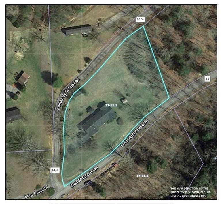
| Acres: | 1.83 +/- |
| Address: | 20 Canterbury School Road, Hinton, WV 25951 |
Agent Contact:
Randy S. "Riverbend" Burdette, 304-667-2897

MAPS & DOCUMENTS-CLICK LINKS TO VIEW
Canterbury School Rd Home Google Earth
Canterbury School Rd Home topo
Canterbury School Rd Home gen. loc. map 2
Canterbury School Rd Home area map 1
Canterbury School Rd Home area map 2
Canterbury School Rd Home national park map
Canterbury School Rd Home state map
Canterbury School Road 1.83 Ac plat
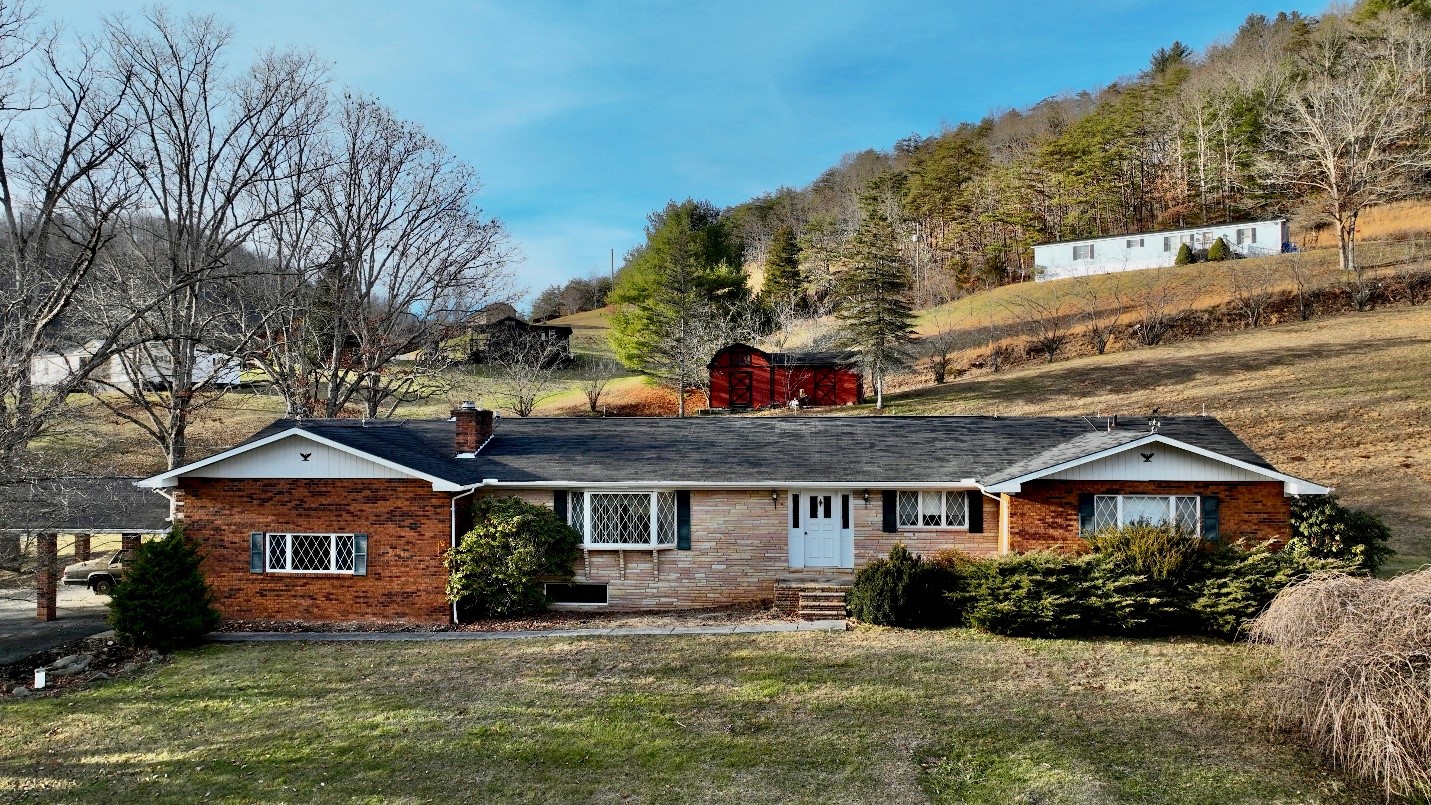
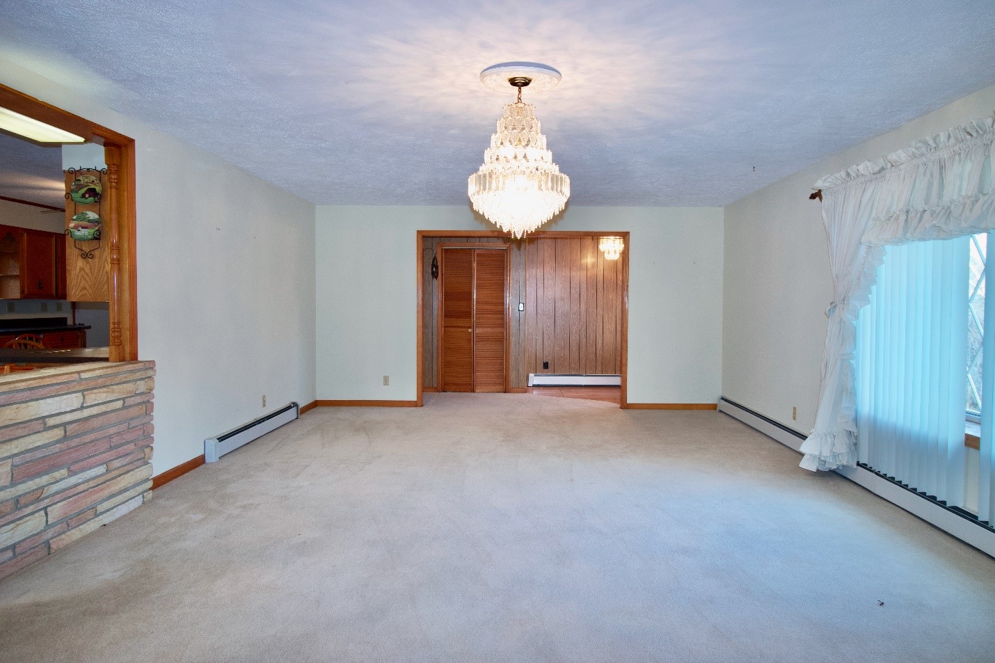
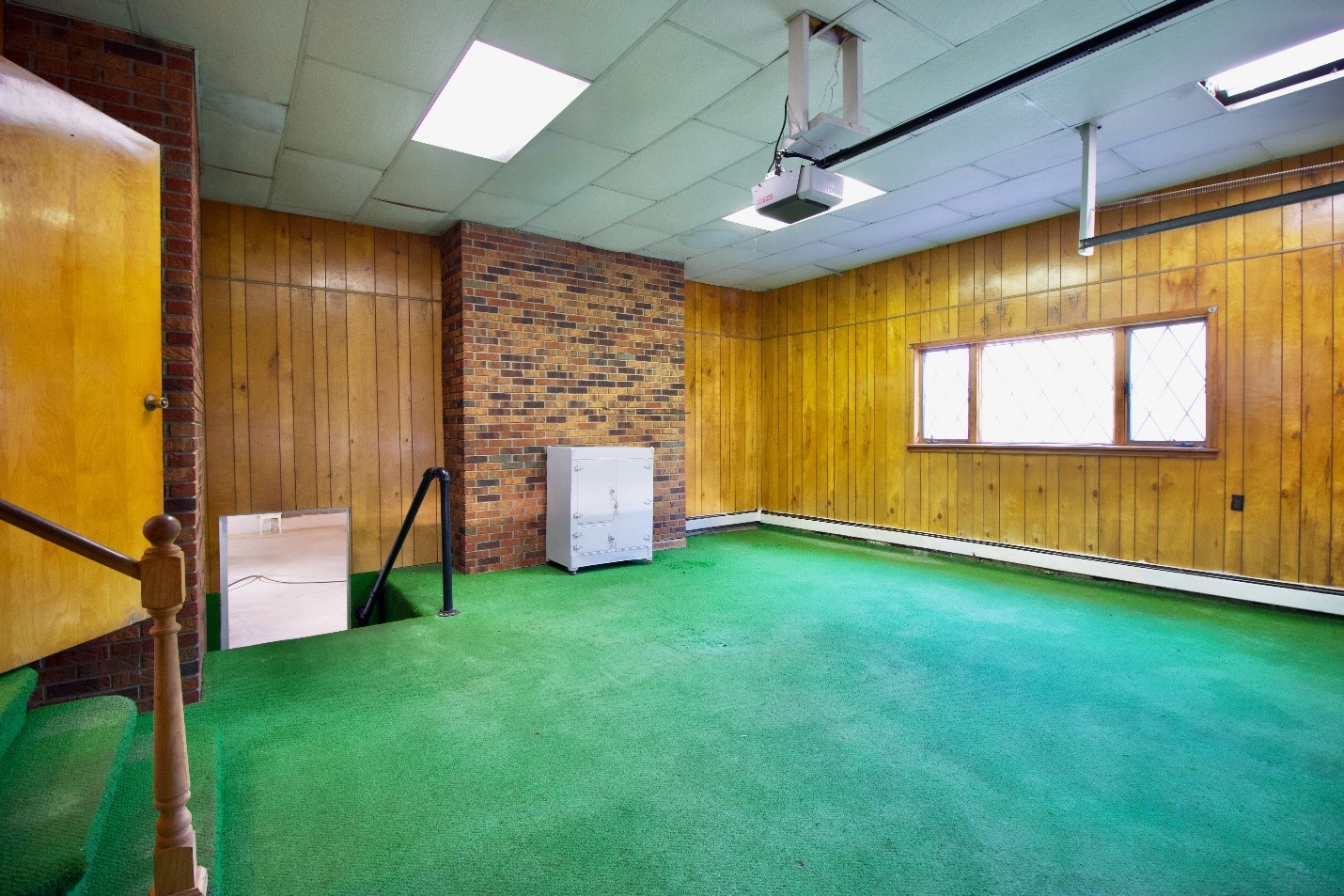
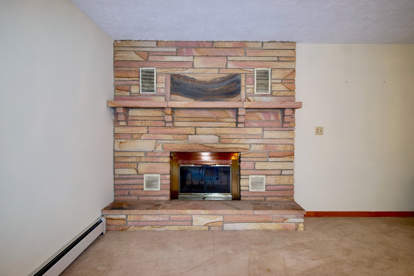
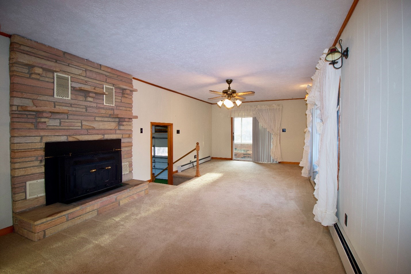
Canterbury School Road Homeplace, aka Cook’s Corner in the Country, is located in Almost Heaven, Summers County, West Virginia, near the community of Forest Hill. The property is only about 15 minutes to Hinton, the county seat of government, shopping, and dining. This outstanding brick ranch home was constructed in 1978 by master builder Tommy Mounts. The home is on a corner lot of 1.83 acres +/- at the junction of Little Wolf Creek Road and Canterbury School Road. The house features four large bedrooms and two full bathrooms. The house is approximately 2565 square feet of heated living area. You will find a large, inviting living room and a spacious kitchen. Some special features of the property include the famous Muddy Creek Mountain flagstone that was quarried at nearby Alderson, WV. The home has two flagstone fireplaces; one is in the family room and has a wood-burning Buck Stove insert. The other flagstone fireplace is in the huge living room and includes propane logs, or it could become a wood-burning fireplace. The house also includes a very functional 3/4 size dry basement with tall ceiling heights. The basement is equipped with a legendary Mealmaster wood cook stove.
HIGHLIGHTS
- Almost Heaven Summers County, West Virginia
- Country living in Greenbrier Rural Tax District
- 83 Acres
- Corner location
- Superior paved state road access
- School bus route
- Easy drive to shopping and schools
- Low property taxes
- Excellent small community lifestyle
- Four Bedrooms with large closets
- Two full bathrooms
- Total square footage 2565 per public records
- Extensive use of the famous Muddy Creek Mountain flagstone
- Two wonderful Muddy Creek Mountain flagstone chimneys
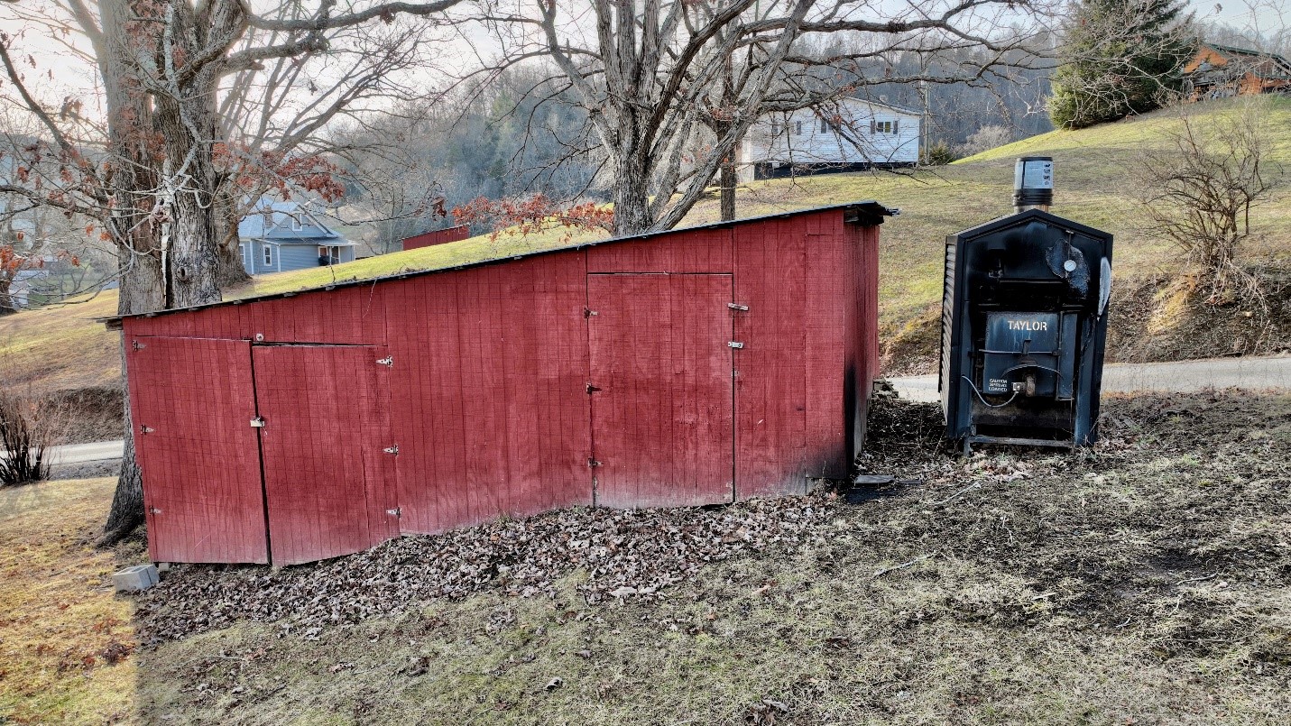
- Central heat via Taylor outside wood stove
- Buck Stove insert in family room fireplace
- Large, heated basement of approximately 1269 square feet
- Basement heat is by a Mealmaster wood cook stove
- The basement is an excellent canning kitchen
- The framework of an additional bathroom in the basement exists
- Tall ceiling heights in the basement
- Brick and Muddy Creek Mountain Flagstone exterior
- Shingle roof
- Constructed circa. 1978 by master builder Tommy Mounts
- Front entrance foyer with hardwood floors
- Wall-to-wall carpet
- Linoleum floors in the kitchen
- Ample storage kitchen cabinetry
- Fold away kitchen cupboard
- Dishwasher
- Side-by-side refrigerator
- Countertop electric range
- Built-in electric double ovens
- Whole house fan
- 200-amp breaker box
- Dual entrance sunroom
- Sliding patio doors to access the back of the house
- Attached heated garage with astroturf carpet
- Large, covered carport in front of the attached garage
- Paved driveway
- Large wood shed
- Outbuildings
- Covered picnic gazebo
- Huge front living room with center bay window and Muddy Creek Mountain flagstone fireplace with propane gas logs
- Incredible crystal chandelier in the living room
- Custom wooden breakfast set at end of kitchen
- Huge rear family room
- Large formal dining room

ROOM SIZES
Living Room 28.4 x 15.6
Front Foyer 6.10 x 12.4
Kitchen 18.2 x 12.4
Dining Area 16.5 x 12.8
Family Room 23.7 x 12.4
Sunroom 6 x 10.9
Master bedroom 16.6 x 17.6
Master bathroom 6.8 x 9.1
Center hallway bathroom 6.2 x 9.1
Bedroom Two 17 x 13.10
Bedroom Three 12.2 x 12
Bedroom Four 11.9 x 12.4
Hallway 25.8 x 7.2
BASEMENT
47 X 27
GARAGE
23.1 x 23.4
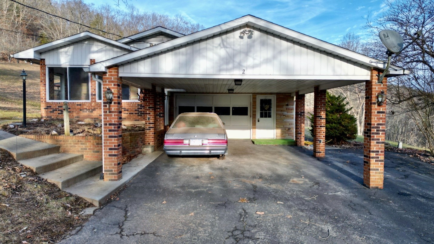
COVERED CARPORT
24.2 x 20.11
OUTBUILDINGS
Woodshed 16 x 12
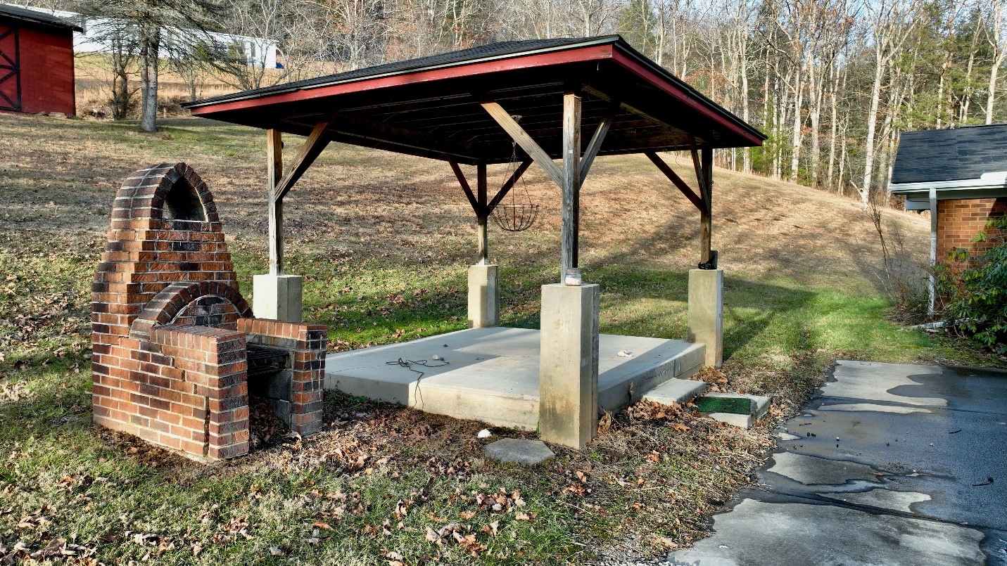
Covered Gazebo with concrete floor 8 x 14
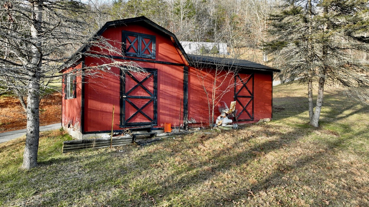
Barn-style building with two sections, 8 x 16 and 8 x 10
Metal outbuilding 10 x 12
*All measurements are from public records
MUDDY CREEK MOUNTAIN FLAGSTONE
From the quarry at Alderson, WV
The sandstone strata at the summit of Muddy Creek Mountain is renowned as a dimensional stone. Medium-grained, multi-colored, and hard, it has been used for more than a generation for slab and block construction. Builders and designers notably appreciate its durability and color, which varies from pink to rose to red and white.
That durability has resulted in its popularity in construction, and given its broad color spectrum and high polishability, the stone has been popular as a finish in many residences, notably in the Greenbrier and Kanawha Valleys.
GEOLOGY
Classified by geologists as the Droop Mountain Sandstone, it may exceed 100 feet in thickness and may best be known for its occurrence on the summit of Droop Mountain to the northeast. There it has calved into a group of house-sized boulders that is the centerpiece of Beartown State Park.
In its 1939 report on the geology of Greenbrier County, the W.Va. Geologic Survey notes that the stone’s durability has resulted in its appearance as a capstone on mountain chains in the region, and this circumstance has led to remarkable purity and durability.
“Due to the fact that it is much more resistant than the beds immediately above and below it,” geologist Paul H. Price noted in the report, “the Droop Sandstone is often found capping the ridges. Under such conditions, weathering often removes much of the iron in the sandstone, leaving a nearly pure silica sand that appears to have the properties of a glass-sand. In some localities, the Droop sandstone is strongly cemented with secondary silica and appears to be durable enough for road material.”
Stone in the area of the quarry notably has a low thermo-mechanical response and can be heated rapidly to high temperatures without cracking or deforming.
LOCATION
Google Coordinates: 37.603167°(N), -80.822476°(W)
Address: 20 Canterbury School Road, Hinton, WV 25951
Elevation Range: 1638 ft. to 1708 ft. +/-
Drive Times
Towns/Interstate Highways
Athens and Concord University: 40 minutes
Beckley: 50 minutes
Hinton: 20 minutes
Princeton: 50 minutes
Sandstone and I-64: 35 minutes
Airports

Greenbrier Valley Airport, Lewisburg, WV, 55 minutes
Raleigh County Memorial Airport, Beckley: 55 minutes
Mercer County Airport, Bluefield: 1 hour
Yeager International Airport, Charleston, WV, 2 hours
Roanoke Regional Airport, Roanoke, VA 1 Hour 36 minutes
Recreation
Bluestone Dam and Lake: 15 minutes
Bluestone Lake Marina: 20 minutes
Bluestone State Park: 20 minutes
Camp Creek State Park and Forest: 1 hour
Glade Springs Resort: 50 minutes
Grandview Country Club: 45 minutes
Little Beaver State Park: 50 minutes
John Henry Historical Park and Monument: 10 minutes
New River Gorge National Park and Preserve Visitors Center, Sandstone: 40 minutes
Pipestem Resort State Park: 30 minutes
Three Rivers Avian Center: 35 minutes
Willow Wood Country Club and Golf Course: 10 minutes
Winterplace Ski Resort: 50 minutes

WILDLIFE
Years of progressive wildlife management practices in the area have created the ideal wildlife preserve. Early on, management goals promoted overall wildlife health, facilitated game harvest, developed wildlife viewing areas, increased carrying capacity, and increased species diversity.
The Bluestone Lake, Greenbrier River, and New River significantly contribute to the local ecosystem’s richness and diversity for plants and animals.
There are many animals that live year-round around the edges of the farms in the area, including raccoons, opossums, turtles, salamanders, newts, crayfish, muskrats, bullfrogs, eagles, hawks, redwing blackbirds.
The area’s diverse tree species help create the perfect wildlife habitat. The “edge effect” created between farm fields, hollows, and ridges benefits all the resident wildlife. Bald eagles, red-tail hawks, whitetail deer, black bears, wild turkeys, squirrels, rabbits, raccoons, foxes, and many species of songbirds, owls, and raptors make up the resident wildlife population.
The nearby hardwood forests provide an essential nutrient source and produce hard mast, including acorns, hickory nuts, beech nuts, and black walnuts. Soft mast includes stag horn sumac, black cherry, tulip poplar seeds, maple seeds, autumn olive berries, and blackberries.
WATER
The home is served by a 79 foot deep drilled well near the front corner of the garage.
MINERAL RESOURCES
West Virginia is one of the states in the US that has two ownership titles, those being SURFACE RIGHTS and MINERAL RIGHTS. A title search for mineral rights ownership has not been conducted. All rights the owner has will convey with the property. A mineral title search could be conducted by a title attorney at the same time when the surface title search is being conducted.
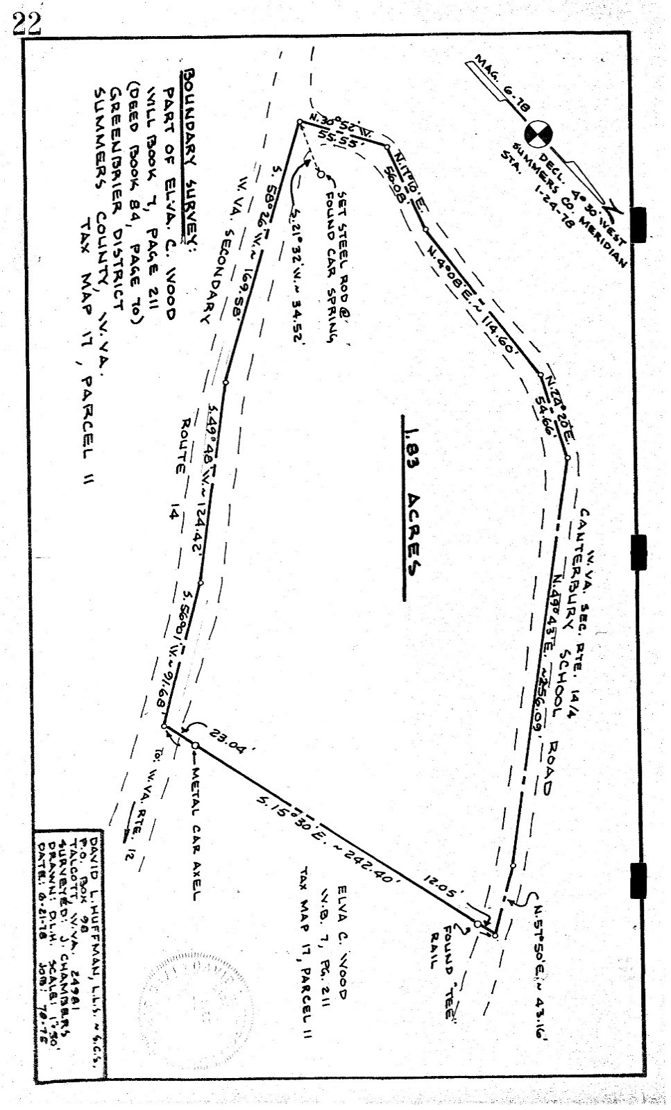
BOUNDARIES AND SURVEY
The property was surveyed in 1978, and the plat prepared from that survey is recorded in DB 131 Pg. 22. The northern, western, and southern boundaries run with state roads. The property is being sold by the boundary and not by the acre.
UTILITIES
Water: Private Well (79 feet deep)
Sewer: Septic system (pumped in 2021)
Electricity: MonPower – account 11044791156
Propane: RT Rogers Oil
Telephone: Frontier Communications
Trash pickup, weekly: Southern Sanitation
Internet: Frontier Communications, and Starlink may be available
Cellphone Coverage: Good
ACCESS/FRONTAGE
The property has extensive frontage on both Little Wolf Creek Road Rt. 14 and Canterbury School Road Rt. 14/4. The property driveway connects directly to Canterbury School Road.
ZONING
Summers County currently has no known zoning or subdivision regulations. However, all prospective buyers should consult the County Government and also the Health Department for any changes and details regarding zoning, building codes, and installation of water wells and septic systems.
PROPERTY TYPE/USE SUMMARY
The property has been used as a residential home property since 1978.
DEED and TAX INFORMATION
Deed Information: part of WB 31 Pg. 104 (back deed is DB 131 Pg. 19)
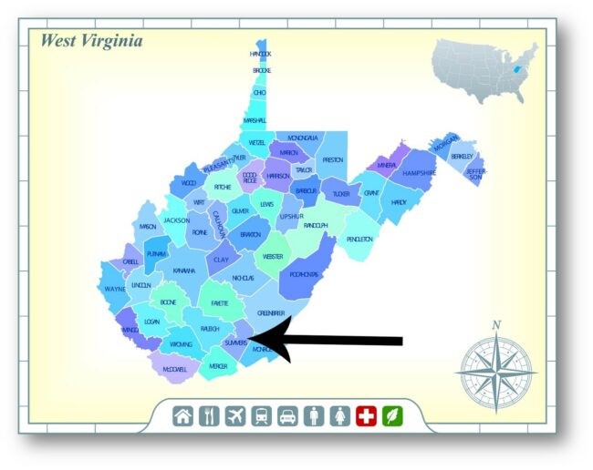
Summers County, West Virginia
Acreage: 1.83 acres +/-
Real Estate Tax ID/Acreage/Taxes:
Summers County (45), West Virginia
Greenbrier District (2)
Tax Map 17 Parcel 11.3; Class 3
2023 Total Real Estate Taxes: $1110.58
SUMMERS COUNTY
HINTON
Hinton is the southern gateway to New River Gorge National Park and Preserve. The town has a large historic district, a railroad museum, antique shops, and restaurants. After crossing the bridge at Hinton, you will begin driving alongside the New River down River Road. There are great riverside vistas on this favorite route for a casual drive along the waterfront. Boaters, motorcyclists, fishermen, and vehicle cruises on the roadway and the river are a common sight. Nestled in the foothills of the Allegheny mountains lies a place where the rivers flow, and the eagle’s soar. A place where small-town charm is around every corner and outdoor recreation is the norm. A place where porch sitting is earned after days spent hiking, biking, boating, and fishing. It is a place that remembers its past and looks toward the future.
Banking, healthcare facilities, a regional hospital, fast food restaurants, drugstores, grocery stores, hardware, auto parts, and farm supply are readily available in nearby Hinton, the county seat of Summers. Hinton has some local hometown restaurants that are wonderful places to meet friends and enjoy a great home-cooked meal.
The unincorporated community of Forest Hill has a fire department, a medical clinic, a post office, an art gallery, and an Amish baked goods store.
TALCOTT, HILLDALE, LOWELL, AND PENCE SPRINGS
The small communities of Talcott, Lowell, and Pence Springs are a vital part of the community. Talcott is the home of the famous John Henry legend and hosts a yearly festival called John Henry Days. Talcott has the John Henry Park, a museum, and a post office. Hilldale has a brand-new Dollar General Store plus a convenience general store with gasoline sales. Lowell is home to the famous Lowell Market, a general store complete with a deli with the best breakfast biscuits for miles around. The store sells food, sporting goods, bait, hardware, lottery tickets, and other goods. Pence Springs is the home of the awesome Pence Springs Flea Market, held on Sundays from April – to the end of October. Dozens of vendors set up offering antiques, collectibles, guns, households, and various goods and tools. Another mainstay in Pence Springs is the Country Road Store, known to locals as the Pence Springs Wallyworld. The stocked inventory includes food, gasoline and fuels, pizza, sporting goods, camping supplies, and hardware. As a former owner, Bird Keatley used to say, “If we don’t have it, do you need it”? Greenbrier Girls Academy, sitting high on a knoll in Pence Spring, is a private school on the grounds of the former Pence Springs Hotel
THE SURROUNDING AREA
BLUESTONE LAKE
Amidst the beautiful scenery of southern West Virginia lies the long Bluestone Lake. This reservoir, the third largest lake in West Virginia, is popular for its fishing and other recreational activities. Bluestone Lake was formed by a concrete dam built by the U.S. Army Corps of Engineers across the New River to reduce flooding. Although the dam was started in 1941, its construction was delayed because of World War II, and it was not fully completed until 1952. The lake is nearly eleven miles long, with an area of 2,040 acres during summer pool, though the water level does change frequently. The Lake can grow to over thirty-six miles long at the flood control pool. At higher levels, the lake extends into Giles County, Virginia. The Lake’s Catchment Area is 4,565 square miles. Water levels are drawn down four feet in winter to make room for melting snow and spring rain.
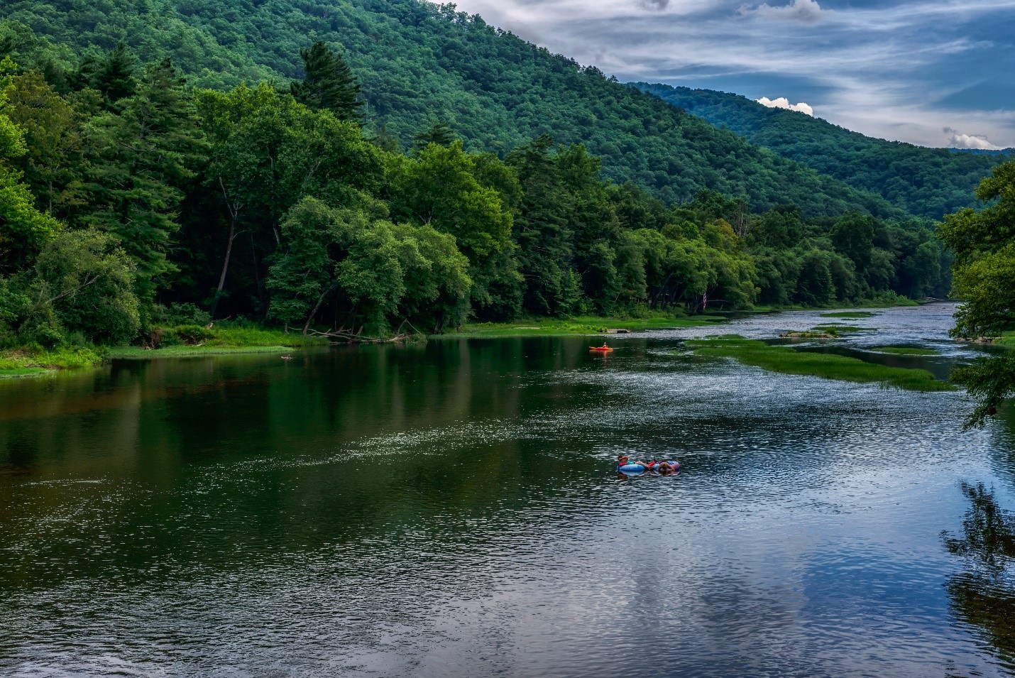
Bluestone Lake, Greenbrier River, and the New River are beautiful places for fishing, and it is said that the New River is the best warm-water fishery in the state. Some of the species of fish available in the lake and river are bluegill, catfish, crappie, muskellunge, and several types of bass. New River bass has set some West Virginia state records.
In addition to fishing, Bluestone Lake is fantastic for enjoying all sorts of water activities, including boating, canoeing, water skiing, and wakeboarding. The lake has several boat ramps and a commercial marina for the boater’s convenience, and there are no limits to the size of boats or motors that can be on the lake.
Bluestone Lake is part of the Bluestone Wildlife Management Area, which covers an area of 18,019 acres. The Wildlife Management Area is known for having some of the best hunting in the area, and hunters and trappers will be able to catch a variety of game, including whitetail deer, turkey, fox, and other animals.
A beautiful place to enjoy the lake is Bluestone State Park. The Park has ample accommodation for those who want to stay overnight. There are a variety of campsites – or, if you prefer a more comfortable stay, there are twenty-six cabins with TVs, showers, and other modern conveniences. Park visitors can take a walk on the hiking trails, play in the swimming pool, or rent game equipment to play croquet or horseshoes. The Park also has weekly events with lots of fun activities.
In addition to all the fun activities on the lake, there is plenty more to do in the surrounding area. There are several other parks nearby where you can enjoy all sorts of outdoor activities. You can experience some great whitewater on the New River. And the New River Gorge is well-known as a wonderful place for rock climbing, with its many hard sandstone cliffs. If you want a break from outdoor activities, the nearby town of Hinton has many attractions. There are a variety of restaurants, shops, and antique stores to browse and museums to visit.
Historical and recreational interests located in the Bluestone area includes the outdoor musical drama “Hatfields and McCoys” and other shows performed at Grandview Park, near Beckley. Pipestem Resort, with its myriad recreational facilities, is only nine miles to the south, and the 80,000 acres New River Gorge National River Park, the center of some of the state’s best whitewater rafting and canoeing, plays an integral part in the area. Of special note are Sandstone Falls and the Visitor Center, just north of Hinton, and Bluestone National Wild and Scenic River, which flows into Bluestone Lake within the park boundaries.
BLUESTONE LAKE MARINA
Bluestone Lake Marina offers guests lake opportunities for water-oriented recreation. Depending on lake conditions, it is open from April 15th through October 15th.
At the marina, you can rent fishing boats, pontoon boats, kayaks, canoes, and slip rentals, as well as cabin rentals conveniently located near Bluestone Lake and Bluestone State Park. Fuel, bait, and snacks are available for purchase.
BLUESTONE WMA – 18,109 ACRES The property is a 15-minute drive to West Virginia’s Bluestone Wildlife Management. The statewide Wildlife Management Program is designed to conserve and manage high-quality habitats for a variety of wildlife species and to improve public access to these resources. West Virginia provides numerous opportunities to learn and appreciate the abundant wildlife.
Bluestone Wildlife Management Area offers visitors a variety of outdoor recreational opportunities on 18,109 acres. Being adjacent to Bluestone Lake, the state’s third-largest body of water, the area offers guests boating, canoeing, and fishing opportunities. The section of the lake from just upstream of the Bluestone River to Bluestone Dam is in Bluestone State Park; the rest of the lake in the West Virginia basin comprises Bluestone WMA.
Hunting is offered due to the wildlife management area status, and Bluestone has over 330 primitive campsites and picnic sites. Avid fishermen can enjoy float fishing and stocked trout fishing in Indian Creek. Hiking and equestrian trails are also popular.
Bicycles are permitted on main roads, day-use areas, and campground areas. Many of the roads leading to Wildlife Management area campgrounds are dirt roads which provide an experience similar to off-road bicycling.
BLUESTONE STATE PARK
Bluestone State Park was established in 1950 and is named after the Bluestone National Scenic River, which flows into the New River at the park. Bluestone State Park encompasses over 2,100 acres of rugged, heavily forested, mountainous terrain and provides a variety of water-oriented activities for guests and residents of southern West Virginia. This Park is five miles south of Hinton, WV.
Classic Cabins at Bluestone State Park are available for rent year-round. The campgrounds, although seasonal by nature, are popular campsites with visitors. Hiking and the opportunity to view eagles make Bluestone a neat area to visit.
Bluestone State Park has twenty-six modern, fully furnished cabins with kitchens, showers, linens, towels, cooking utensils, dishes, tableware, and modern appliances. Each cabin also has a stone fireplace, grill, picnic table, and campfire ring. Cabins are available for rent year-round and accommodate two to eight people. Select cabins are pet friendly. Guests also have access to nearby Pipestem Resort State Park’s indoor facilities, including an indoor pool and sauna, for some more rest and relaxation.
Bluestone State Park has four campgrounds with 120 campsites. The Meador Campground has thirty-two sites open to RVs and tents, with electricity and water available at seven of the sites, electric at 15 sites, and a central bathhouse are also on-site. The Tent Area Campground has five rustic sites and is designed for group camping. Old Mill Campground, open to tents and RVs, has forty-four rustic campsites and a central bathhouse. East Shore Campground has thirty-nine primitive sites accessible by boat only. The campgrounds are open from mid-April through late October. Campground reservations are available from Memorial Day through Labor Day each year. Campgrounds are open on a first-come, first-serve basis through October 31.
An extra plus is that Bluestone Park is adjacent to Bluestone Lake, the state’s third-largest body of water. Due to this sizeable lake, boating, and fishing are naturally an important part of the recreational opportunities at the park. The addition of hiking trails, a swimming pool, game courts, and a seasonal nature/recreation program creates a well-rounded array of activities. The proximity of Bluestone to the Winter Place ski area makes the park’s rental cabins affordable accommodation for ski groups and winter vacations.
Nearby is “The Year-Round Crown Jewel of West Virginia State Parks,” Pipestem, which is known for its scenic overlooks and an aerial tram ride into the Bluestone Gorge. Park amenities include an 18-hole, par seventy-two championship golf course with several restaurants and snack bars.
BLUESTONE DAM
Bluestone Dam, located at Hinton, is one of the major flood control dams in West Virginia. It has the largest drainage area and flood storage capacity of any dam in the state. It is built across New River, one mile above its junction with the Greenbrier River and two miles below the confluence of New River and Bluestone River. Prior to the construction of the Bluestone Dam, flooding was a major problem in this great river system.
Bluestone Dam was authorized in 1935 by an executive order issued by President Franklin Roosevelt. Construction on the project began in 1942, but work was suspended in 1943 because of World War II. Work resumed in January 1946, and the dam was completed for operational purposes in January 1949 and totally completed in 1952. The approximate cost was $30 million.
With a drainage area of 4,565 square miles, Bluestone Dam controls 44 percent of the river flow through the populous Kanawha Valley, which is downstream. It is a concrete gravity dam 165 feet high and 2,048 feet long, administered by the U.S. Army Corps of Engineers. Normal release of water from Bluestone Lake is accomplished through sixteen sluices in the base of the dam. The 790-foot spillway has twenty-one floodgates. There are also six sluiceways for hydroelectric power that have not been used in the early decades of the dam’s history. The maximum discharge capacity is 430,000 square feet per second.
The dam contains 942,000 cubic yards of concrete and 7,800 tons of steel. Its lake has a summertime surface of 2,040 acres and is extremely popular with boaters, skiers, and fishermen. Bluestone State Park, located on the Bluestone River about three miles above the dam, provides lodging, camping, a restaurant, and recreational facilities.
The Bluestone Dam celebrated its 50th anniversary in 1999 when the Army Corps of Engineers estimated that the dam had prevented more than $1.6 billion in flood damages. Bluestone ended its first half-century with important improvements underway. The lake became a major supplier of public water in 1997, serving Hinton and Princeton and a large area between and around those two communities.
Reinforcements were added to the dam under the federal Dam Safety Assurance Program, with raising the dam by eight feet, installing anchors, and thrust blocks to tie the dam into bedrock, spillway improvements, and other work. The second phase, installing bedrock anchors, is underway, and three additional phases remain to be constructed. Simultaneously, work began to add hydroelectric capacity to the dam in a partnership between Hinton and other communities and private industry.
Hydroelectric Power Generation Project: Bluestone Dam was originally designed for Federal hydropower, and six penstocks were constructed through the east abutment. During World War II, construction activities were delayed, during which time interest in Federal hydropower declined.
The Water Resources Development Act of 2000 authorized Tri-Cities Power Authority (TCPA) to design and construct a hydropower-generating facility at Bluestone Dam. TCPA is made up of the West Virginia cities for Hinton, Philippi, and White Sulphur Springs.
Until the early 2000s, the penstocks were capped and never modified. Between 2001 and 2017, the Corps modified the penstocks to create an auxiliary spillway as a required Dam Safety Action.
The Corps and TCPA initiated negotiations for the installation of a non-federal hydropower facility at Bluestone Dam, but these negotiations were put on hold as the Corps advanced required dam safety actions so TCPA could re-assess the project. Bluestone State Park was established in 1950 and is named after the Bluestone National Scenic River, which flows into the New River at the park. Bluestone State Park encompasses over 2,100 acres of rugged, heavily forested, mountainous terrain and provides a variety of water-oriented activities for guests and residents of southern West Virginia. This Park is five miles south of Hinton, WV.
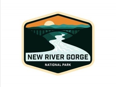
THE NEW RIVER GORGE NATIONAL PARK and PRESERVE
The 70,000-acre New River Gorge National Park and Preserve is a unit of the United States National Park Service (NPS) designed to protect and maintain the New River Gorge in southern West Virginia in the Appalachian Mountains. Established in 1978 as a national river, the NPS-protected area stretches for fifty-three miles (85 km) from just downstream of Hinton to Hawks Nest State Park near Ansted. The Park was officially named America’s 63rd national park, the U.S. government’s highest form of protection, in December of 2020, amid the COVID-19 pandemic as part of a relief bill.
West Virginia is home to parts of the Appalachian National Scenic Trail, a footpath that stretches between Maine and Georgia; the Lewis & Clark National Historic Trail, which cuts through sixteen states for 4,900 miles; the Bluestone National Scenic River; and Harpers Ferry National Historic Park. Now, over 70,000 acres of land bordering fifty-three miles of the gorge have earned the government’s protection.
The New River Gorge National Park and Preserve is rich in cultural and natural history and offers an abundance of scenic and recreational opportunities. New River Gorge is home to some of the country’s best whitewater rafting, mainly from the Cunard put-in to the Fayette Station take-out, and is also one of the most popular climbing areas on the East Coast.
Home to the New River, which drops 750 feet over sixty-six miles, with its Class V rapids, has long drawn adventuresome rafters and kayakers to this whitewater area. The New River, which flows northward through low-cut canyons in the Appalachian Mountains, is actually one of the oldest rivers on the planet.
Rock climbing on the canyon walls, mountain biking, and hiking on trails that flank the river, and wildlife viewing—bald eagles, osprey, kingfishers, great blue herons, beavers, river otters, wild turkeys, brown bats, snakes, and black bears, are all within the park.
Begin your experience with a stop at Canyon Rim Visitor Center, which is situated on the edge of the gorge, for maps, current information, and chats with a park ranger. You can learn any pertinent safety protocols and visit the bookstore.
The New River Gorge Bridge is a work of structural art. Construction of the bridge began in 1974 and was completed in 1977. The Bridge spans 3,030 feet in length and is the third-highest bridge in the U.S., at 876 ft. During Bridge Day, an annual one-day festival celebrating the construction of the Bridge, BASE jumpers launch off the 876-foot bridge and parachute down to the New River. New River Gorge is the only national park in the U.S. that permits this extreme activity.
President Jimmy Carter signed legislation establishing New River Gorge National River on November 10, 1978. As stated in the legislation, the park was established as a unit of the national park system “for the purpose of conserving and interpreting outstanding natural, scenic, and historical values and objects in and around the New River Gorge and preserving as a free-flowing stream an important segment of the New River in West Virginia for the benefit and enjoyment of present and future generations.” The New River Gorge National Park and Preserve Designation Act was incorporated into the Consolidated Appropriations Act 2021, changing the designation to New River Gorge National Park and Preserve. Less than 10% of the original national river was re-designated as a national park, where hunting is no longer permitted, while the remainder is a national preserve with minor change.
NEW RIVER REGION OVERVIEW
The New River is shared by boaters, fishermen, campers, park visitors, and local neighbors. The waters of the New River system contain a mosaic of hydrologic features and aquatic habitats that support a highly productive aquatic ecosystem that includes distinct populations of native fish, mussels, crayfish, and a broad array of other aquatic life, including rare amphibians, reptiles, birds, and mammals.
The 320-mile New River rises in the Blue Ridge region of North Carolina and flows northeastward through the Appalachian uplands to Radford, Va., where it turns northwestward and passes through a series of narrow valleys and gorges into southern West Virginia. It ends where it joins the Gauley River to form the Kanawha River. In WV, the New River is entrenched in a steep and narrow valley, the narrowest part of which is known as the “New River Gorge.”
In 1998, because of its historical, economic, and cultural importance, President Clinton signed into law the New River as one of the very first American Heritage Rivers. Much of the river’s course through West Virginia was designated as the New River Gorge National River. In 2021, the area was designated as the United States’ newest National Park.
The New River is recognized as the “second oldest river in the world” and is estimated to be between 10 and 360 million years old. Its headwaters begin near Blowing Rock, NC, and it is one of the few rivers in North America that flows northerly.
Class I, II, III, IV, and V rapids dot the entire 320 miles of New River, making it a great paddling, tubing, and whitewater rafting adventure. Beautiful cliffs, bluffs, and mountain views make it one of the most scenic rivers on the east coast.
New River Gorge National Park includes fifty-three miles of free-flowing New River, beginning at Bluestone Dam, and ending at Hawks Nest Lake. The New River typifies big West Virginia-style whitewater. Within the park, it has two vastly different characters. The upper (southern) part of the river consists primarily of long pools and relatively easy rapids up to Class III. It is a big powerful river, but exceptionally beautiful, always runnable, and provides excellent fishing and camping. There are a number of different river access points, and trips can run from several hours to several days.
The lower (northern) section of the river is often referred to as “the Lower Gorge.” In a state that is justifiably renowned for colossal rapids, the Lower Gorge has some of the biggest of the big, with rapids ranging in difficulty from Class III to Class V. The rapids are imposing and forceful, many of them obstructed by large boulders which necessitate maneuvering in powerful currents, crosscurrents, and hydraulics. Some rapids contain hazardous undercut rocks.
Prior to the rise of the Appalachian Mountains, the New River cut its bed at a time when the land sloped to the northwest. Amazingly so, as the Appalachians gradually rose around the river, the New River wore away the bedrock at the same rate the mountains formed, leaving behind towering cliffs and prominences that hover hundreds of feet about the water level.
Accounts claim that Indians referred to the New River as the “river of death” however, this origin story is likely legend. Native Americans and early European settlers regarded the New and Kanawha rivers as being one single waterway. The name “New” may have been derived when the river upstream was discovered by European explorers as the first “new” river found flowing westward.
Native American Indians used the New River as they traveled west years before the pioneers arrived. In the 1600s, explorers navigating the New River thought they were close to the Pacific Ocean because of its westerly flow.
In 1671 the Batts-Fallam expedition, by way of the New River, came through to the Lurich area and ended there because the Indian guides refused to take them any farther. They carved their initials in a tree and claimed the territory for King Charles II of England. This was the first proclamation of English territory west of the Alleghenies, making the New River the first gateway into the west.
Fast water, big rocks, and lazy/slow stretches are features of the New River. Water sports enthusiasts will find the New River ideal for swimming, canoeing, fishing, kayaking, tubing, snorkeling, paddle boarding, and windsurfing. Great fishing is found in the New River, with bass (largemouth, smallmouth, and rock), flathead catfish, channel catfish, muskie, walleye, and bluegill present in good numbers. Year after year, it produces more citation fish than any other warm water river in WV.
The New River Gorge was a vast and largely unsettled wilderness until the C&O railroad was built on the eastern side of the river in the 1880s. The railroad opened the rich coalfields and virgin timber stands of the region. Early “mountaineers” settled the area and soon were carving out mountain farms and raising families.
The gorge was practically impassible before the completion of the New River Gorge Bridge, near Fayetteville, WV, in 1978. The river within its gorge is one of the most popular whitewater rafting destinations in the eastern U.S. Much of the New between Hinton and Gauley Bridge is managed by the National Park Service.
Principal tributaries of the New in West Virginia include, from south to north, the East River, the Bluestone River, and the Greenbrier River.
Many former mining communities located on the New River in its gorge have since become ghost towns. These include Sewell, Nuttalburg, Kaymoor, Fayette, South Fayette, Hawks Nest, Cotton Hill, and Gauley, Beury, and Claremont.
MONROE COUNTY
Banking, healthcare facilities, drugstores, grocery, hardware, auto parts, and farm supplies are readily available in nearby Union and Peterstown. There are no fast-food restaurants, but there are local restaurants that are excellent places to meet friends and enjoy a great home-cooked meal.
Some of the friendliest people in West Virginia can be found in Monroe County. Monroe County has a population of about 13,000 residents, does not have a stoplight, and has more cattle and sheep than people. Monroe County is an exceptional area with interesting folks, both “born and raised” and newer members from many states. People from all walks of life reside in harmony in this lovely pastoral setting.
UNION
Shortly after Monroe County was created, James Alexander offered twenty-five acres of land, including a lot for a courthouse, which in time became the town of Union. On January 6, 1800, the Virginia Assembly passed an act creating the town of Union.
The Monroe County Historical Society preserves several historic structures in the town, including the Caperton Law Office, Owen Neel House, Clark-Wisemen House, Ames Clair Hall, and the Old Baptist Church. The Union Historic District was placed on the National Register of Historic Places in 1990.
PETERSTOWN
The Town of Peterstown is a short drive. Banking, healthcare facilities, drugstores, grocery, hardware, auto parts, and farm supply are readily available in Peterstown. The town is on the border with Virginia, and Virginia Tech is less than an hour from Peterstown.
Peterstown was chartered in 1803 by the Virginia General Assembly and incorporated in 1892 by the Circuit Court. Peterstown was named for Christian Peters, a Revolutionary war soldier who settled nearby and founded the town shortly after the Revolutionary War. The town is the site of the 1928 discovery of the 34.48 carats (6.896 g) Jones Diamond by Grover C. Jones and his son, William “Punch” Jones.
SALT SULPHUR SPRINGS
Salt Sulphur Spring near Union is a popular wedding venue and is the scene of select community events.
The area is well known for the healing waters of the numerous “Sulphur Springs.” During the 1800s and early 1900s, several “Sulphur Springs Resorts” flourished in the area. Most notably and still in existence are White Sulphur Springs, Warm Springs, and Hot Springs. Others included Sweet Springs, Blue Sulphur Springs, Red Sulphur Springs, Green Sulphur Springs, Pence Springs, and Sweet Chalybeate Springs.
During the height of wealthy families’ summer treks to the Virginia springs resorts—from roughly 1800 until the Civil War—one popular circuit encompassed “the fountains most strongly impregnated with minerals, heat, fashion, and fame,” according to one chronicler. For those arriving from eastern Virginia and points northeast, the circuit started at Warm Springs northeast of Lewisburg in the Allegheny Mountains. From there, it ran south and west to the Hot, the White Sulphur, the Sweet, the Salt Sulphur, and the Red Sulphur, then back in the opposite direction.
The “Old Salt” was famed for its three springs: sweet, salt sulphur, and iodine, curative especially for “chronic diseases of the brain” such as headaches.
The main hotel building dates to about 1820. Salt Sulphur Springs Historic District holds one of the largest groupings of pre-Civil War native stone buildings in West Virginia.
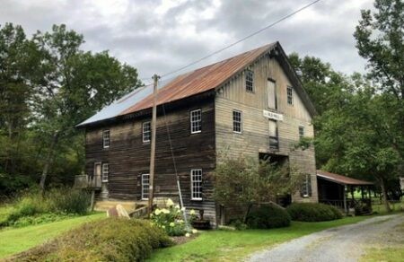
GREENVILLE (Centerville)
Just a few miles away lies the sleepy village of Greenville. Greenville is the classic old Virginia community with the historic Cook’s Mill still standing on the banks of Indian Creek. The Ziegler Family that currently owns Cook’s Mill has the grounds open for visitors to enjoy picnics and view the massive water wheel and the exterior of the building. Greenville has a country general store complete with gasoline sales. The post office is still open and a community meeting place.
RED SULPHUR SPRINGS/BALLARD
Red Sulphur Springs, located just a few miles away, was once the site of another popular mineral spring resort from the 1820s until World War I. The spring water emerges from the ground at 54 degrees F. and leaves a purplish-red sulfurous deposit which was used to treat skin conditions. The water was believed to be useful in the treatment of tuberculosis. Modern analysis shows the water to be high in bicarbonate, sulfate, and calcium. Around 1920, the buildings were dismantled, and the resort ceased operation.
INDIAN CREEK
Indian Creek takes its name for a Native American trail that crossed the Appalachians from the valley of the Ohio River to that of the Great Valley of Virginia. “It was the interstate of the Indian world.”
Indian Creek is a tributary of the New River. It is one of Monroe County’s main drainage basins. Indian Creek begins its journey near Salt Sulphur Springs and drains tens of thousands of acres on its winding 30-mile-long trip through pastoral farms, steep mountain canyons, wide bottomland forests, wetlands, and marshes before ending its trip close to Crumps Bottom, where it enters New River. From there, the New River flows to the Kanawha, onto the Ohio, then the Mississippi, and terminating in the Gulf of Mexico. It is said that the waters of Indian Creek will arrive in the Gulf of Mexico 3 to 4 days after entering the New River.
INDIAN CREEK COVERED BRIDGE
Owned by the county historical society and open to pedestrians, it was part of the White and Salt Sulphur Springs Turnpike. A Long truss built in 1903 by Ray and Oscar Weikel (ages 16 and 18 years old) and E.P. and A.P. Smith, it is more than 11.5 feet wide and 49.25 feet long. There are six covered bridges in West Virginia with this truss engineering — Philippi, Hokes Mill, Sarvis Fork, Statts Mill, Center Point, and Indian Creek. The completed bridge cost Monroe County only $400 and was used continuously for about 30 years.
The interior of the Indian Creek Bridge contains notes and plaques from previous visitors. Now only pedestrians use the bridge, which also houses antique vehicles from the 1900s, adding to the history of this unique structure.
In the spring of 2000, the bridge was rehabilitated by Hoke Brothers Construction, Inc. of Union, WV, in 2002 at a cost of $334,446. Renovations included timber roof trusses, a new glue-laminated timber deck, new wooden exterior siding, and a new roof of split shakes.
Indian Creek Bridge is a tribute to the ingenuity and hard work of two young builders who had a vision of what transportation could be in Monroe County.
CASCADE FALLS (45-minute drive)
One of the most visited falls in Virginia is only a short drive away. About 150,000 visitors a year visit the Cascades. Without question, Cascade Falls is one of the most beautiful waterfalls in Virginia and possibly on the entire East Coast. Little Stony Creek falls over a vertical cliff in several different streams. Several streams cascade a couple of times on the way down while others fall the whole distance of the falls.
The 69 ft. falls crash into a large pool surrounded by two-hundred-foot cliff walls from which large ice formations hang in the winter. The scene is both breathtaking and peaceful as the falls combine both power and beauty. The falls are also fairly easy to view, with wooden stairs and platforms on one side of the pool, allowing a visitor to get close to the falls as well as allowing a photographer many different angles for photographs.
MEDICAL CARE (4.5 mi.) (7 minutes)
Monroe Health Center has a clinic at nearby Forest Hill.
Summers County ARH Hospital is 8.2 miles away and a 12-minute drive.

VETERANS MEDICAL (35 miles, 56 min)
West Virginia has VA Hospitals in Clarksburg, Martinsburg, Beckley, and Huntington. The Beckley, WV Hospital is about a 35-mile drive. Nearby Salem, VA, Veterans Hospital is about a 90-minute drive. Other Nearby Community-Based Outpatient centers are in Princeton and Ronceverte.
PUBLIC SCHOOLS
Summers County School District
Public Elementary School:
Talcott Elementary School
Public Middle School:
Summers County Middle School
Public High School:
Summers County High School
College:
Concord University (nearby in Mercer County)
DIRECTIONS
From Hinton, WV: (10 Miles +/-) (14 Minutes +/-) From McDonald's on Stokes Drive, take Stokes Drive across the river bridge and turn left onto Route 3 East and 12 S, travel 5.3 miles, and then bear right onto Route 12 South at the Willowood Bridge interchange, then travel 3.2 miles, turn right onto Little Wolf Creek Road Rt. 14 (also known as Buck) and travel 1 mile and the property is on the right at the corner of Canterbury School Road. From Peterstown: (18.6 Miles +/-) (24 Minutes +/-)
From Reece’s Hardware on US Route 219, take Route 12 North for 17 miles; turn left onto Little Wolf Creek Road Rt. 14 (also known as Buck) and travel 1 mile and the property is on the right at the corner of Canterbury School Road.
From Union (26.2 mi.) (36 Minutes +/-)
From the Monroe County Courthouse, take US Route 219 South for 8.3 miles and turn right onto Route 122, then travel 13.4 miles and turn right onto WV State Route 12 North. Travel 3.4 miles, turn left onto Little Wolf Creek Road, Rt. 14 (also known as Buck), and travel 1 mile and the property is on the right at the corner of Canterbury School Road.
REGIONAL INFORMATION
STATE INFORMATION
- State of West Virginia
- West Virginia Explorer
- West Virginia Government
- West Virginia State Parks
- West Virginia Tourism
- Wonderful West Virginia Magazine
- WV Department of Natural Resources
- Virginia – Commonwealth of Virginia
- Virginia is for Lovers
- Virginia Museum of History & Culture
- Virginia Museum of Natural History
- Virginia National Park Service
- Virginia Recreation
- Virginia State Parks

Contact Foxfire
304.645.7674
Gallery


