DRY FLY EAST
Sold!

130 unspoiled woodland acres with 1/2 mile of direct frontage on the wild Smith River
| Price: | |
|---|---|
| $199,000 | |
| ID: | 736 |
| Acres: | 121.9 +/- |
| Address: | |
Agent Contact:
Richard Grist, 304.645.7674

MAPS & DOCUMENTS-CLICK LINKS TO VIEW
Dry Fly East area attractions map (Foxfire)
Dry Fly East real estate tax land use classification map (Foxfire)
Dry Fly East aerial location map (Foxfire)
Dry Fly East area map (Foxfire)
Dry Fly East general location map (Foxfire)
Dry Fly East Google Earth map (Foxfire)
Dry Fly East location map (Foxfire)
Dry Fly East state map (Foxfire)
DRY FLY EAST
121.9 unspoiled woodland acres with 1/2 mile of direct frontage on the wild Smith River.
Dry Fly is a riverfront retreat that boasts gently sloping forestland with mature hardwoods and plentiful wildlife. Roads and trails throughout property provide access to possible home sites and to some 3000FT +/- of frontage on the Smith River, known for excellent trout fishing and never-ending fun.
The Smith River provides the excitement of life on one of Virginia’s popular wild rivers. The focus of a vast outdoor-recreation destination, it flows out of the lofty Alleghenies, attracting anglers, paddlers, and naturalists from across the globe.
“Dry Fly East” has some 3,000 feet of river frontage on the Smith River and 121.9 acres of majestic forest nestled in the foothills of the beautiful Blue Ridge Mountains. Located in an area of free flowing rivers, quiet lakes and sweeping mountains vistas, this exceptional recreational property has a rich history, and is blessed with a variety of noteworthy recreational, cultural and historical resources.
The Smith River provides the excitement of life on one of Virginia’s popular wild rivers. The focus of a vast outdoor-recreation destination, it flows out of the lofty Alleghenies, attracting anglers, paddlers, and naturalists from across the globe.
Dry Fly East is located near the city of Martinsville in the southwestern corner of Henry County near the Virginia-North Carolina Line. The foothills of the majestic Blue Ridge Mountains combined with the Piedmont region create a beautiful backdrop. Formally a strong tobacco-based economy, the community evolved early in the 1900’s into a manufacturing center known as a major producer of fine furniture, wood products, and textiles.
The area’s location within a ninety-minute commute to Raleigh/Durham/Chapel Hill and Greensboro NC is also significant.
LOCATION
Google Coordinates: 36.783668°{N), -79.977439°(W)
Address: Off RT 673 Sunset Drive, Bassett, VA 24055
Elevation Range: 804 ft. to 1139 ft. +/-
- Washington, D.C. 293 miles
- Norfolk 232 miles
- Greensboro NC 50 miles
- Winston-Salem, NC 55 miles
- Charlotte, NC 125 miles
- Richmond, VA is 150 miles
- Roanoke 50 miles
The region offers unique locational advantages, placed halfway between the Roanoke Valley and the Piedmont Triad, with direct connections via US Highways 220 and 58. US 58 is an efficient access route to the Port of Hampton Roads. The future 1-73 corridor is designed to run directly through Martinsville/Henry County which will drastically improve the drive times and access to the Midwest and southern Mid-Atlantic region.
Interstates
• 1-40 30 miles, 1-77 34 miles, 1-85 35 miles, 1-81 74 miles, 1-73 36 miles, 1-581 64 miles Note: Measured from border of locality/region from Martinsville.
Highways 4-Lane
• Highway 87, Highway 174, Highway 220, Highway 57, Highway 58
Airports
• Piedmont Triad International Airport, Greensboro, NC 39 miles
• Roanoke Regional Airport, Roanoke 67 miles
• Lynchburg Regional Airport, Lynchburg 91 miles
• Raleigh/Durham International Airport, Raleigh/Durham, NC 116 miles
Rail Service
• Norfolk Southern Railway Company
Shipping Ports
• Port of Richmond
• Virginia Inland Port at Front Royal
• Norfolk International Terminals
WATER
The property has about 1/2 mile of frontage on the Smith River and has two feeder streams. One is a dashed blue line stream that lies within the property for about ¼ mile until it joins into the Smith River. The other is a blue line stream that runs along the northern side of the property for about ¾ mile until it joins into the Smith River. Those streams flow during rain events and periods of snow melt. Additional ephemeral streams flow at those times as well. The streams drain directly into the Smith River, which then flows into the Dan River.
PROPERTY USE SUMMARY
Recreation and wildlife management is the primary use of this all wooded 130 acre property (fishing, hunting, boating, hiking, nature viewing, star gazing).
CEMETARY: G.G Stone Family Cemetery
There is a very small family cemetery located near the entrance of the property. Two of the prominent headstones are G.G. Stone (1827-1903) and his consort Olive (1830-1888) “She made home happy”.
MINERAL RESOURCES
A title search for actual mineral ownership rights is recommend. All rights the owner has will convey with the property.
BOUNDARIES AND SURVEY
The property is being sold by the boundary and not by the acre.
UTILITIES
Water: Private well could be drilled
Sewer: Private septic could be installed
Electricity: Roadside
Telephone: Nearby
Internet: Cell phone hotspot, Satellite, or possible phone cable
Cellphone Coverage: good in most locations on the property
ACCESS/FRONTAGE
The property is accessed by a private gravel road that joins onto County RT 673. The primary access road is gated and graveled, and travels into the property for about 1 mile, attaching to other access travel ways within the property. Forest trails provide access to nearly every corner of the property. The property is accessible by water via the Smith River.
ZONING
There is a conservation easement in place with the Virginia Outdoors Foundation. The easement covers 102 acres of the property and the deeded conservation protections run with the property. The remaining 28 acres are outside of the conservation easement and to not have deeded conservation protections.
Henry County has adopted uniform zoning regulations that govern land usage in the county. All prospective buyers should consult the County Government and Health Department for any changes and details regarding zoning, building codes, and installation of water wells and septic systems.
DEED AND TAX INFORMATION
Deed Information: L0900/04415, L1000/04580, L1100/02679 Henry County, Virginia
Acreage: 121.9 acres +/-
Real Estate Tax ID/Acreage/Taxes:
Henry County, Virginia RC District
Property ID: 049230000, Tax Map Number 15.2(000)000/2591; 8.5 Acres (LU: Residential)
Property ID: 094900001, Tax Map Number 15.4(000)000/011; 11.299 Acres (LU: Cons Easemt)
Property ID: 094900002, Tax Map Number 15.2(000)000/247; 56.689 Acres (LU: Cons Easemt) Property ID: 094900003, Tax Map Number 15.2(000)000/259; 32.180 Acres (LU: Cons Easemt) Property ID: 094900004, Tax Map Number 15.2(000)000/0003,4; Lots 3 & 4 (LU: Cons Easemt) Property ID: 224200000, Tax Map Number 15.5(000)000/239; 21.00 Acres (LU: Residential)
2019 Real Estate Taxes: $331.90
PUBLIC SCHOOLS
Henry County School District
Public Elementary Schools:
Axton Elementary School Campbell Court Elementary School Collinsville Primary
Drewry Mason Elementary School
Public Middle School:
Fieldale – Collinsville Middle School
Public High School:
Bassett High School
Bengal Tech Academy of Global Studies
DIRECTIONS
Driving Destination Google Coordinates: 36.783668° (N), -79.977439° (W) At entrance of the graveled property road
From downtown Martinsville, Virginia: 14 miles+/- (approximately 30 minutes)
Travel US-220 BUS North to the intersection of the 4-lane US 220 and RT 57 (aka Fairystone Park Highway); travel VA -57 W 3.3 miles to RT 673 Sunset Drive (across from the Bassett Post Office); turn right onto Sunset Drive; immediately after crossing the railroad, turn left to continue with Sunset Drive; travel RT 673 Sunset Drive for 2 miles; turn left onto Florence Drive (gravel road at the mailboxes that are in front of the brick house); travel 3/10 mile; entrance to the road into the property is on the left.
- 10 minutes from 4-lane US 220
- 20 minutes from the Martinsville Speedway
- One hour from Roanoke, VA
- One hour and 15 minutes from Greensboro, North Carolina
- One hour and 20 minutes from Winston – Salem, North Carolina
THE FOREVER GIFT – A CONSERVATION EASEMENT
Mindful of the public benefit flowing from the conservation values of their land and the threats posed to those values in a climate of increasing development pressure, the sellers donated to The Virginia Outdoors Foundation, a non-profit, an open space easement restricting the use and development of a 102 acre portion of their land in perpetuity. The intent of the perpetual easement is to forever preserve the existing rural landscape and to preserve the scenic environment and the watershed. 28 acres of the property is not included in the easement.
The Dry Fly East conservation easement allows the owners to permanently protect their land from future, more intensive uses, while still maintaining ownership. The owner may continue to utilize the property as before the easement except that certain rights in ownership are no longer available. The easement allows traditional uses of the property such as farming, forestry, hunting, hiking, and fishing.. Other permitted uses include horticulture, agriculture, viticulture, aquaculture. silviculture, and equine activities, temporary or seasonal outdoor activities.
The terms of the Conservation Easement will be furnished upon request.
THE SMITH RIVER – AMAZING!!
The Smith River is very well known for its native brown trout fishery. Fly fishermen enjoy casting to these trout year-round in the tailwaters of Philpott Lake, which keeps the water cool and the fish active. In addition to native brown trout found there, the Virginia Department of Game and Inland Fisheries stocks portions of the river with rainbow trout as part of their put-and-take-program.
From Philpott Lake, the Smith River travels 44 miles on its way across Henry County before entering North Carolina. Ten public river access points provide excellent access to the river. The river’s character is constantly changing along the way, and accommodates many different fishing styles. As the water temperatures warm up further downstream, small mouth bass and redbreast are abundant.
The Smith River Trail System: This 44 mile long “Blueway” has 10 river access points and flows through the towns of Bassett, Stanleytown, Fieldale, Martinsville, and Ridgeway, once the heart of furniture and textiles in America. The river trail features rock outcrops, rapids, interesting scenery, and Native American fish weirs still intact on sections of the river. Additionally, there are nearly 20 miles of shared-use trails for hiking, bike riding and more.
The Smith River Fest is held annually at the Smith River Sports Complex in Henry County. This event is a celebration of all things associated with the Smith River. Participants can ride the river, learn to fly-fish, browse vendors and compete in in the Hellgrammite Hustle 5K Mud Run.
RECREATION AT DRY FLY EAST
Dry Fly East offers unparalleled recreational opportunities. Numerous soft recreational activities are anchored by the one-half mile direct frontage on the Smith River. The easy going 130 acres consist of old fields, emerging forest and very mature forest which provide the foundation for all that is Dry Fly East.
Nature viewing is first in line of recreational activities. Attentive wildlife management has been geared not to just game animals. Equal consideration has been extended to increasing the numbers and diversity of species including neo-tropical songbirds, butterflies, turtles, frogs, rabbits, chipmunks, dragonflies, owls, hawks.
Stargazing-Planet Observation
Complete darkness can be still be found on the majority of the property, thereby affording the opportunity to view the night sky in all its brilliant wonder.
Water-sports enthusiasts will find the Smith river ideal for: Swimming, boating, fishing, kayaking, tubing, snorkeling, paddle boarding and wind-surfing.
Shooting-sports devotees find all the land and privacy needed to enjoy:
- Paintball-Airsoft-Laser tag-Archery tag
- Shotgun sport shooting including Skeet, Trap, Double Trap and Sporting Clays
- Rifle & Handgun shooting: bullseye, silhouette, western, bench rest, long-range, fast draw
- Archery and Crossbow competition shooting
- Plinking: Grandpa’s old 22 single shot rifle and a few tin cans make a fun day
All Terrain Motorsports
Dry Fly East has internal roads and forest trails that are perfect for experiencing the property from an ATV or UTV. These exciting machines handle the wide variety of Dry Fly East terrain. The riders can go from down along the river, wind through the pine and hardwood forest and up to the highest ridge.
Dirt bikes can also be a lot of fun and they come in all sizes and horsepower to fit anyone who enjoys being on two wheels.
Mountain biking, horseback riding and hiking
The same trails used for Motorsports can also be used for mountain biking or horseback riding. The trails are designed to be on gentle grades but some trails coming off the river offer a more challenging climb.
Hunting at Dry Fly East is a first-class experience. The ½ mile direct river frontage provides habitat for wood duck, geese and mallards. White tail deer, black bear, red/gray fox, bobcat, wild turkey, grouse, squirrel, raccoon, and rabbit make up the resident wildlife population. The great mix of wildlife id due to attentive management for many years.
AREA RECREATION
The area is a haven for fishermen and water sports enthusiasts. The 3,000-acre Philpott Lake boasts an undeveloped shoreline. Smith Mountain Lake has 500 miles of shoreline and offers water activities, lodging, fishing and big boating sports. The Smith River offers some of the best native brown trout fishing in the state. And Fairy Stone State Park offers 4,750 acres of hiking, picnicking, swimming, boating, fishing, tent sites, RV hookups, cabins and camping lodges. The area has four private golf clubs and two public courses. Other sporting opportunities include the Martinsville Speedway, which hosts two Monster Cup NASCAR races each year, and the Martinsville Astros, a rookie league affiliate of the Houston Astros. Forty-five minutes west of Martinsville is the Blue Ridge Parkway, ranked “America’s most scenic drive” by leading travel writers, offering 469 toll-free miles of awesome natural beauty and pioneer history.
THE AREA
The area’s location within a ninety-minute commute to Raleigh/Durham/Chapel Hill and Greensboro NC is significant. The area is realizing an influx of young families, commuting professionals, early retirees and baby boomers, who have discovered the countryside and the uncrowded lifestyle of Henry County and the Martinsville area along the lakes and rivers.
Entrepreneurs and “gentleperson farmers” are looking for farms either for development purposes or for private use.
The area is popular with individuals coming from Northern Virginia, Washington DC, and North Carolina, citing Virginia’s mild four-season climate and access to the areas surrounding rivers and lakes as attractive features drawing them to this region. The region’s recreational features represent a significant and relatively untapped draw for the future, particularly in regard to tourism and property value appreciation.
Henry County is part of the lower Valley and Ridge area of Virginia, characterized by a belt of folded and faulted sedimentary rocks that have formed a northeast-southwest trend of linear ridges and valleys, creating the picturesque views for which the region is known. Because of the dramatic change in elevation across the County, there are numerous scenic views of distant mountains, rivers, lakes and pastoral valleys.
As with most rural area of Virginia in recent history, relatively inexpensive land, as compared with more northern and densely populated regions of the state, has fueled development. The County’s workforce can easily commute to several surrounding counties both in Virginia and North Carolina, while still enjoying the rural and scenic nature of their home area. Dry Fly East is located only a 20 to 40-minute drive to larger metropolitan services areas including the cities of Martinsville, Danville, and Roanoke.
WILDLIFE MANAGEMENT
Years of progressive wildlife management have created the quintessential wildlife preserve. Early on, management goals included establishing food plots intended to promote overall wildlife health, facilitate the harvest of game, develop wildlife viewing areas, increase carrying capacity, and increase species diversity.
A few sites throughout the property have been designated as permanent food plots. These areas include small woodland openings, riverbank buffers, forest management trails, interior access roads, pine thickets, naturally regenerated hardwood areas, and old field comers.
The natural wildlife food sources of fruit and nut trees, shrubs, hedges, vines and other plant materials are present. This natural habitat is most appealing to the species of wildlife.
The mixture of mature forest, emerging forest, trails, utility corridors, old farm fields, and old fruit trees, coupled with the abundant water supply from the Smith River, create the perfect wildlife habitat. The “edge effect” created by the river, old fields, railroad track, forest trails, access roads, and utility right of way is the textbook habitat for the resident wildlife. The edges create a miles long linear wildlife food plot.
The hardwood forest produces tons of acorns, hickory nuts, beech nuts and soft mast. White tail deer, black bear, red/gray fox, bobcat, wild turkey, grouse, squirrel, raccoon, fox and many species of songbirds, eagles, owls and raptors make up the resident wildlife population. It is hard to find a property that has a better mix of wildlife as there has been professional wildlife management for many years.
Mineral licks are also an important part of the overall food plot program. Mineral licks provide essential minerals not provided by the food plot or natural vegetation.
THE RIVER WILDLIFE HABITAT
The Smith River is a major contributor to the local ecosystem richness and diversity for both plants and animals. Great fishing is found in the Smith River with rainbow trout, small mouth bass, crappie, catfish, and bluegill present in good numbers.
The river, ephemeral creeks and its surrounding aquatic plant life create a water supported community with a wide variety of wildlife. Some of the margin of the river is fringed by wetlands, and these wetlands support the aquatic food web, provide shelter for wildlife, and stabilize the shore of the river. The plant life associated with the wetland includes rushes, sedges, cattails, duckweed, bee balm and algae.
There are many animals that live in the water and around the edges of the river and creeks including beavers, otters, weasels, raccoons, opossums, blue herons, bald eagles, Canada geese, wood ducks, mallards, minnows, native fish, turtles, salamanders, newts, crayfish, muskrats, bull frogs, and redwing blackbirds.
Of course, and most importantly, is the insect and microscopic world including butterflies, dragonflies, water skaters, water beetles, damselflies, hellgrammites, tadpoles and various insect larvae.
FOREST/TIMBER RESOURCES
Dry Fly East’s 121.9-acre forest is a noted Tree Farm and Stewardship Forest registered with the Virginia Department of Forestry. A broad ridge and wide bowl funnel into steeper hollows that empty into the Smith River.
The timber resource is comprised of quality eastern hardwoods and pine. This well managed forest will provide a great deal of flexibility to the next ownership in terms of potential harvest revenue and can be managed to provide cash flow opportunities to offset holding cost and long term asset appreciation.
Forest-wide, most stands are fully stocked to overstocked, providing the next ownership with a great deal of flexibility in shaping their own silvicultural legacy. Stem quality forest-wide can be considered excellent with the forest containing an abundant current and future sawlog source.
The forest’s timber component has been well managed over the years. Portions of the forest were thinned as prudent forest management called for. The forest could benefit from immediate thinnings which would generate considerable income and improve forest health. The forest has matured into higher-value sawtimber diameter classes with an abundant growing stock already in place for the future.
Diameters are well represented across the commercial spectrum with a notable mature size class, as well as abundant pole size timber and growing stock.
A few “Heritage Trees” are scattered throughout the forest. These ancient trees, some 150+ years old, have withstood the test of time, weathering ice, wind, lightning strikes and fire.
The forest is very healthy. The Emerald Ash Borer is present, and the Ash component is in decline. There have been no forest fires in the recent memory.
The forest floor is home to several types of mushrooms, medicinal plants, ferns and cool green mosses. Sheet Moss is a type of Forest Moss and is also referred to as Mood Moss, which is quite appropriate.
Some of the forest was in fields 50 – 70 years ago and piles of field stone are found along the old field edges. These stone piles are a lasting testament of the backbreaking work the early settlers put in to create a homestead.
Beechnuts, Hickory nuts, sweet White Oak and Red Oak Acorns provide a sustainable food source for the squirrels, chipmunks, whitetail deer and wild turkey that live in abundance in the forest.
GEOLOGY This is the land of heat and pressure
Henry County is located in the Piedmont Physiographic Province and is underlain by igneous, metaigneous and metasedimentary rocks, plus Triassic sedimentary rocks. Some of the rocks were formed over 600 million years ago in the Precambrian Era. Predominant rock formations at Dry Fly East are classed as a metamorphic rock and more defined as a mica schist. Other types of rock found in the area are granite, quartz, feldspar, mica, gneiss, claystone, shale, and siltstone.
“FAIRY STONES” There are “lucky fairy stones” in the area as well. Legend says fairies were dancing here when news came of Jesus’ crucifixion. The terrible details made them weep, and their falling tears turned into tiny crosses of stone, which sank into the ground and endured long after the fairies disappeared.
Some treasure the stones for their religious symbolism. The superstitious believe that fairy stones protect against witchcraft, sickness, accidents and disaster. Under the dusty red coat, fairy stones come in five colors, said to represent all the human races: red, white, yellow, light brown and blackhe stones are still here.
Fairy stones are staurolite, a composition of iron aluminum silicate that forms only under extreme heat and pressure, as built up by the Blue Ridge Mountains. Originally, the stones were formed about seven miles underground. As the mountains began to rise up, it brought the fairy stones to the surface.”
As staurolite crystals grow, they often intersect to form crosses. The most common shape is a St. Andrew’s cross, which looks like an X. Roman crosses are shaped like a plus sign. Maltese crosses, the rarest, have crossbars at the ends. Rain and wind carve the fairy stones out of the softer surrounding rock, called schist.
Virginia is one of five locations where fairy stones are found. Patrick County has one of the highest concentrations in the world. Other areas that have the stones are, Georgia, New Mexico, Brazil and Switzerland
ARCHEOLGY
Native American artifacts found in the area include arrowheads, spear points, tomahawks, tools and toys (marbles). 90% of the artifacts in the area would be from the Archaic period and should be readily found on any flat areas on the river that would be one foot higher than the riverbank.
Archaeological evidence from sites surrounding the Smith River indicate that the river was first visited by hunter-gatherers during the late Paleo lndian (ca. 9,000-8,000 B.C.) and Early Archaic (8,000-6,000 B.C.) periods. From this early period through ca. A.D. 1200, the Smith River Valley was visited seasonally, by small bands of hunters taking advantage of the rich fauna inhabiting the river valley. The flood plains surrounding the Smith River were first permanently settled by Virginia Indians in the late prehistoric era, known archaeologically as the Late Woodland period, and regionally as the Dan River Phase. Between A.D. 1250 and A.D. 1450, Siouan-speaking groups of the Virginia and North Carolina Piedmont founded agricultural villages along the length of the river.
Archaeological evidence indicates that village sites along the Smith River were protected by wooden palisades and relied heavily on the cultivation of maize. At least one of these villages, the Philpott site was occupied by the Sara Indians through the 1650’s.
Native American Indians that lived in the Roanoke River Valley, as well as northern Georgia, upper SC and Tennessee where part of the Archaic Period culture. This culture lasted from about 10,000 to 3,000 BP (before present day).
Some of the earliest Europeans to visit the Smith River were members of a survey party led by William Byrd II in 1728, tasked with mapping the Virginia-North Carolina border.
In the 1900’s, tobacco was widely grown in the area and many small tobacco barns dotted the countryside. The tobacco leaves were picked by hand and dried in small barns. Some cut stone may be found that was once the foundation to a barn.
In the late nineteenth and early twentieth centuries, the Smith River emerged as an important source of water power for lumber and textile mills. Initially supplying railroad ties to the new Winston Salem branch of the Norfolk and Western railroad, several lumber operations repurposed their Smith River mills after the completion of the railroad to manufacture wood furniture. Notable among these was Bassett Furniture, established in 1902, which operated continuously until the early 2000’s at the original mill site on the Smith River.
G.G Stone Family Cemetery: There is a small family cemetery located near the entrance of the property. Two of the prominent headstones are G.G. Stone (1827-1903) and his consort Olive (1830-1888) “She made home happy”.
PUBLIC LANDS NEARBY
More than 10,000 acres of public lands are available for nature and recreation enthusiasts to enjoy hiking, horseback riding, biking, hunting and geocaching. These areas include:
- Fairystone Farms WMA – 5,321 acres
- Turkeycock Mountain WMA – 2,697 acres
- Fairy Stone State Park – 168 acre lake
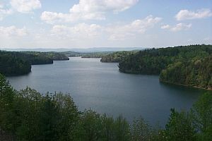
- Philpott Lake 3,000 acres
Boxwood Hunt Club – Private Preserve Open to Members & Guests of Members
PHILPOTT LAKE
- Located among in the rolling foothills of Virginia’s Blue Ridge.

- The lake covers 3,000 acres with 100 miles of shoreland.
- Walleye, smallmouth bass, carp and largemouth bass are just some of the species found here.
- Philpott Lake offers pleasure boaters and paddlers a variety of places to explore including hidden waterfalls, scenic rock outcrops and three islands. Deer Island, the largest of the three, offers nightly camp site rentals that are only accessible via boat.
- Bowen’s Creek Parkand Goose Point Park are some of the other recreational areas offered on Philpott.
- Most areas are under forest cover. There are numerous recreational opportunities, including: boating, swimming, picnicking, hiking, biking, hunting, fishing, and wildlife observation.
- The lake has eight campgrounds, six beach areas, and nine boat launches and a Visitor Center.
- Lake was built by U.S. Army Corps of Engineers between 1948 and 1951, with it opening in 1953. Philpott Lake is convenient to Greensboro, NC (60 miles), Roanoke, VA (50 miles), Winston-Salem, NC (60 miles), and Raleigh, NC (130 miles), and Richmond, VA (190 miles).
PRIMLAND RESORT
Just a few minutes down the road from Dry Fly East is the Primland Resort. Primland offers spectacular views, mountain-top chalets, elegant dining, conference facilities, and a wide array of recreational activities. The activities offered at Primland include Orvis endorsed wingshooting for pheasant, quail and chukar, sporting clays, whitetail deer and wild turkey hunting. Primland also offers fly fishing, ATV tours, horseback riding, and more. An 18-hole championship golf course is a great play. The resort offers client entertainment, conference facilities, corporate outings, beautiful weddings and receptions, family get-togethers, or romantic getaways.
DIRECTIONS
From downtown Martinsville, Virginia: 14 miles+/- (approximately 30 minutes)
Travel US-220 BUS North to the intersection of the 4-lane US 220 and RT 57 (aka Fairystone Park Highway); travel VA -57 W 3.3 miles to RT 673 Sunset Drive (across from the Bassett Post Office); turn right onto Sunset Drive; immediately after crossing the railroad, turn left to continue with Sunset Drive; travel RT 673 Sunset Drive for 2 miles; turn left onto Florence Drive (gravel road at the mailboxes that are in front of the brick house); travel 3/10 mile; entrance to the road into the property is on the left.
REGIONAL INFORMATION
STATE INFORMATION
- State of West Virginia
- West Virginia Explorer
- West Virginia Government
- West Virginia State Parks
- West Virginia Tourism
- Wonderful West Virginia Magazine
- WV Department of Natural Resources
- Virginia – Commonwealth of Virginia
- Virginia is for Lovers
- Virginia Museum of History & Culture
- Virginia Museum of Natural History
- Virginia National Park Service
- Virginia Recreation
- Virginia State Parks

Contact Foxfire
304.645.7674
Gallery


")


")
")