LONE OAK FARM
Sold!

| Price: | |
|---|---|
| $1,400,000 | |
| ID: | 785 |
| Acres: | 294 +/- |
| Address: | |
Agent Contact:
Richard Grist, 304.645.7674

“THE LONE OAK FARM”
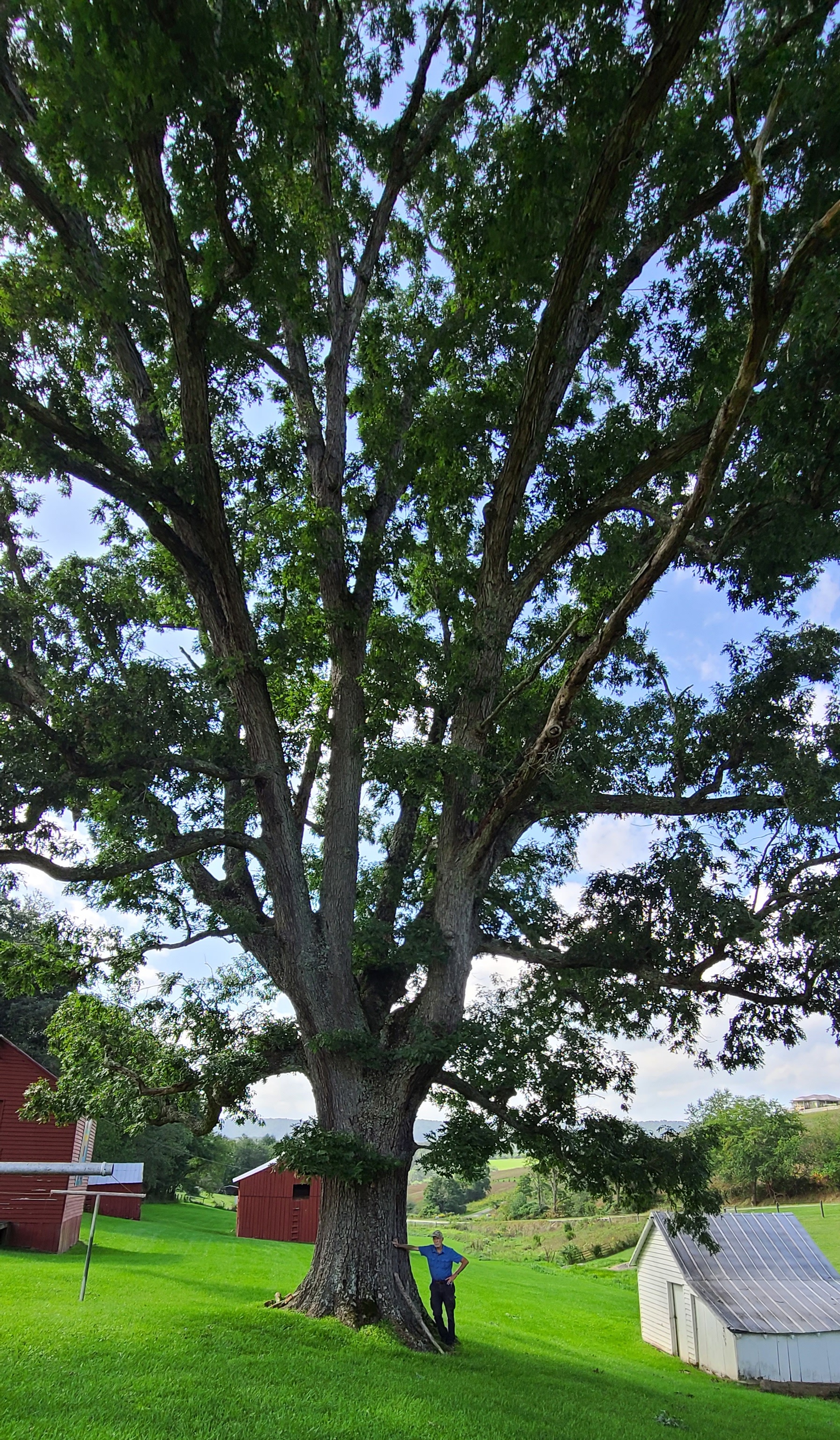
The 294-acre Lone Oak Farm is named for the farm’s last remaining old growth white oak. This virgin white oak once had a sister oak standing beside her until just a few years ago when that tree surrendered to old age and died, leaving the “Lone Oak”.
The Lone Oak stands on the estate grounds near the original 1850’s farmhouse. This magnificent tree is nearly 20 feet in circumference and is one of the largest remaining old growth (virgin) white oaks in the Commonwealth of Virginia. The Lone Oak is estimated to be 200 – 300 years old and thought to have been witness to some 100,000 sunrises and sunsets.
HIGHLIGHTS
- Historic farm circa 1850 with 294 unspoiled deeded acres
- Home to one of the largest old growth White Oak’s in Virginia
- Adjoins the Jefferson National Forest & Appalachian Trail
- Working cattle farm – fenced and cross fenced
- Notable 1850’s original farmhouse, a significant developed spring, several outbuildings
- Tremendous limestone cave with tall rooms, underground stream, 10,000+ years old mineral formations of stalactites, stalagmites, flowstone
- Commercially valuable timber ready for immediate harvest if so desired
- Rich and diverse wildlife population – unrivaled in the region
- Productive hay land, pasture & meadows, all integrated with 124 acres of mature woodland
- Several home sites with stunning long views of distant mountains
- Drilled water well, spring, private septic, electric, landline phone, cell coverage, 4G
- 45 minutes to Roanoke with jet airport, interstate, hospital, shopping, city amenities
- 15 minutes to New Castle, Craig County Seat – 15 minutes to US 460
- Dark skies offer excellent opportunities for star gazing and astrophotography
- Dynamic forest with some old growth trees estimated to be 200-300 years old
- Farm and forest roads wind through the property providing superior access
- Wildlife program enhances habitat, increases diversity, and promotes health
- A rewarding permaculture lifestyle can be easily developed
- Surrounded by national forest, farms and timber tracts in a nice rural neighborhood
- Superior access by state maintained paved roads – FedEx, UPS and USPS delivery
- Elevation Range: 2382 ft. to 3260 ft. +/-
- Cell phone coverage good with 4G service
- Area creekside: Frogs, turtles, crawdads, fish, ducks, salamanders, butterflies, dragonflies
- Area fur bearing – deer, black bear, squirrel, rabbit, bobcat, raccoon, fox, chipmunk, opossum, coyote
- Area winged wildlife – eagles, hawks, owls, grouse, ravens, turkey, woodpeckers, neotropical songbirds
- Agricultural grasses and the forest produce Oxygen and sequester carbon dioxide
- Trees species include oaks, black walnut, poplar, sycamore, maple and hickories
- Perfect for recreational activities including ATV riding, horseback riding, hiking, camping, and nature viewing
- Low taxes, low population density
- 30 min to the New River @ Pembroke and 45 min to the James River at Eagle Rock
- Nature, scenic, and historic attributes provide exceptional quality of life values
LOCATION
Google Coordinates: 37.402716°(N), -80.298777°(W)
Address: 11214 Cumberland Gap Road, New Castle, VA 24127
Elevation Range: 2382 ft. to 3260 ft. +/-
THE HUFFMAN HOMEPLACE
The Huffman Homeplace was built sometime around 1850. The cut stone foundation, 2 hand-cut stone fireplaces, hand hewn logs, and an historic spring house with a bountiful spring, set the scene for one of the county’s most enchanting country estate settings. The home is in excellent condition and is move in ready.
HIGHLIGHTS:
- 11214 Cumberland Gap Road, New Castle, VA
- Circa 1850 2-story farmhouse
- Hand-cut stone foundation
- Hand-hewn logs
- 2-story front porch
- Rear porch
- Exterior siding = Cedar Wood – recently painted
- Roof = metal roof
- Foundation = stone
- Heating – Air Conditioning = electric heat pump
- 2 hand-cut stone fireplaces
- Windows = insulated glass
- Flooring = hardwood and vinyl
- Walls = plaster
- Wood trim throughout
- Crawl space
- 2,364 total sq. ft.
- Main floor sq. ft. = 1,518
- Upper floor sq. ft. = 846
- Porches sq. ft. = 96 and 98
- Total rooms = 6
- 3 bedrooms
- 1 full bath
- Appliances to convey = Range/oven, refrigerator, microwave
- Open concept Kitchen and Dining
EXTERIOR BUILDINGS & FEATURES:
- Newer metal shop building on concrete slab with electricity = 30 x 70
- Two frame outbuildings with metal roofs = 12 x 16
- Grainery = wood frame with metal roof and upper storage
- Older barn with loft in good condition = 30 x 36
- Older log outbuilding with metal roof
- Spring house
- Two detached garages
- Fenced and cross-fenced
THE HUFFMAN CAVE
The Huffman Cave is located in the Sinking Creek Valley of Craig County, and is one of 36 other documented caves in the county. Craig County has over 25,000’ of surveyed underground passages. Cave lengths in the county run up to 8,226’ long with depths reaching up to 240’.
The limestone cave has a large solid limestone entrance, tall rooms, an underground stream, 10,000+ years old mineral formations of stalactites, stalagmites, flowstone and “Speleothem” , which means a natural mineral formation or deposit occurring in a cave.
Cave Terminology
“Cave” means any naturally occurring void, cavity, recess, or system of interconnecting passages beneath the surface of the earth or within a cliff or ledge including natural subsurface water and drainage systems, but not including any mine, tunnel, aqueduct, or other man-made excavation, which is large enough to permit a person to enter. The word “cave” includes or is synonymous with cavern, sinkhole, natural pit, grotto, and rock shelter.
“Speleothem” means a natural mineral formation or deposit occurring in a cave. This includes or is synonymous with stalagmite, stalactite, helectite, shield, anthodite, gypsum flower and needle, angel’s hair, soda straw, drapery, bacon, cave pearl, popcorn (coral), rimstone dam, column, palette, flowstone, et cetera. Speleothems are commonly composed of calcite, epsomite, gypsum, aragonite, celestite, and other similar minerals.
“Cave life” means any rare or endangered animal or other life form which normally occurs in, uses, visits, or inhabits any cave or subterranean water system.
“Material” means all or any part of any archaeological, paleontological, biological, or historical item including, but not limited to, any petroglyph, pictograph, basketry, human remains, tool, beads, pottery, projectile point, remains of historical mining activity or any other occupation found in any cave.
“Sinkhole” means a closed topographic depression or basin, generally draining underground, including, but not restricted to, a doline, uvala, blind valley, or sink.
RECREATION AT LONE OAK FARM
The Lone Oak Farm offers many recreational opportunities. Numerous soft recreational activities are anchored by shared common boundary with the Jefferson National Forest and proximity to the New River and James River.
Nature viewing is first in line of recreational activities. Attentive wildlife management has been geared not just to game animals. Equal consideration has been extended to increasing the numbers and diversity of species including neo-tropical songbirds, butterflies, turtles, frogs, rabbits, chipmunks, dragonflies, owls, hawks.
Stargazing-Planet Observation
Near complete darkness can be still be found on the majority of the property, thereby affording the chance to view the night sky in all its brilliant wonder. Astrophotography opportunities from the property’s highest elevation on Sinking Creek Mountain at 3400’, would offer unobstructed views of 180 degrees of horizon.
Water-sports enthusiasts will find the nearby New River at Pembroke or the James River at Eagle Roack ideal for: Swimming, canoeing, fishing, kayaking, tubing, snorkeling, paddle boarding and wind-surfing.
Shooting-sports devotees find all the land and privacy needed to enjoy:
- Paintball-Airsoft-Laser tag-Archery tag
- Shotgun sport shooting including Skeet, Trap, and Sporting Clays
- Rifle & Handgun shooting: bullseye, silhouette, western, bench rest, long-range, fast draw
- Archery and Crossbow competition shooting
- Plain ole’ plinking with an old 22 single shot rifle and a few tin cans
Mountain Biking, Horseback Riding and Hiking
The farm has several internal forest trails that are perfect for experiencing the property from horseback, mountain bike, ATV, or hiking. Trail users can start out at 2382’ at the farmhouse and wind upwards through agricultural fields and forest, ending at 3267’ on the highest ridge atop Sinking Creek Mountain and the Jefferson National Forest.
WILDLIFE
Progressive wildlife management practices have created the ideal wildlife habitat. The farm’s management goals promoted overall wildlife health, developed wildlife viewing areas, increased carrying capacity, and increased species diversity.
The two dashed blue line streams, several ephemeral creeks and the nearby and much larger Sinking Creek, are major contributors to the local ecosystem’s richness and diversity for both plants and animals. The streams and their associated aquatic plant life create a water supported community with a wide variety of wildlife. Some of the margin of the creeks are fringed by lowlands, and these lowlands support the aquatic food web, provide shelter for wildlife, and stabilize the banks of the streams. The plant life associated with the wetland includes rushes, sedges, cattails, duckweed and algae.
There are many animals that live in the water and around the edges of the creeks including, raccoons, opossums, turtles, salamanders, newts, crayfish, muskrat, bull frogs, hawks and redwing blackbirds.
There is the insect and microscopic world including butterflies, dragonflies, pond skaters, water beetles, damselflies, tadpoles, and various insect larve.
The property has a mixture of mature hardwood species. The diverse tree species, coupled with the abundant water supply from the creeks and springs, creates the perfect wildlife habitat. The miles of “edge effect” created between the farm fields, creeks, hollows, ridges, rock outcrops and the Jefferson National Forest is the textbook habitat benefiting all the resident wildlife. Coyote, white tail deer, black bear, wild turkey, squirrel, rabbit, bobcat, raccoon, fox and many species of songbirds, owls, and raptors make up the resident wildlife population.
The hardwood forest provides the essential nutrient source and produces tons of hard mast including acorns, hickory nuts, beech nuts and black walnuts. Soft mast includes stag horn sumac, black cherry, tulip poplar seeds, maple seeds, autumn olive berries and blackberries.
AGRICULTURAL RESOURCES
The Lone Oak Farm, with its 170+ year history, is one of the premier hay and grazing boundary’s in the Sinking Creek Valley located in Craig County, VA.
The ongoing grassland management program is designed to increase carrying capacity and extend the grazing season. Lone Oak’s well-maintained grasslands also conserve water and filter out manure and nutrients, keeping them from entering nearby water bodies, protecting water quality, human health, and animal health.
The large volume of sugar maple trees could easily make hundreds of gallons of maple syrup if a gravity fed sugarbush were to be established.
- 294 acres total in the farm
- 34 acres level to gently rolling – highly productive cropland – hay fields
- 132 acres of flat to gently rolling pastureland
- 124 acres in mature woodland
- Livestock fencing on a large portion of the boundary
- Cross fencing installed to facilitate rotational grazing and delineate the cropland
- Board fencing is used in residential areas
- Water for livestock is provided by a multi-trough watering system with water provided by a separate drilled well
FOREST/TIMBER RESOURCES
The timber resource is well positioned for value appreciation over the coming decades. With an attractive species mix, adequate stocking levels, and favorable diameter class distribution, the timber amenity represents a strong component of value to the investor.
A timber inventory conducted by a certified forester in 2012, estimates there to be about 500MBF (International Rule) of hardwood sawtimber and some 3000 tons of pulpwood. The total fair market liquidation value, based on local timber stumpage values in October 2012, was about $92,000.
The Lone Oak Farm’s forest resource is composed of quality Appalachian hardwoods. This well managed timber resource will provide a great deal of flexibility to the next ownership and can continue to be managed for the benefit of the farm.
The forest’s predominately well-drained upland terrain has led to a resource dominated by hardwood species. Overall, the species composition is highly desirable and favors Appalachian hardwood types, consisting primarily of:
- Sugar Maple – 29%
- Poplar/Cucumber/Basswood – 20%
- Red Oak Group – 22%
- White Oak/Chestnut Oak – 19%
- Soft Maple – 6%
- Black Walnut – 1%
- Hickory – 1%
- A host of associated species (ash, cedar, birch, sourwood, sassafras, black gum, beech)
Forest-wide, most stands are fully stocked, providing the next ownership with a great deal of flexibility in shaping their own silvicultural legacy. Stem quality forest-wide can be considered excellent with the forest containing an abundant current and future veneer source.
The property’s timber component has been well managed over the years and consists of timber stands of differing age classes, all managed under exacting silvicultural guidelines. The predominant timber stand contains 40 -140-year-old stems ranging in size of 10”-30” dbh. Portions of this stand were thinned 30 to 40 years ago as wise wildlife/forest management called for. There are some small pockets of timber that were not thinned, mostly on the steeper slopes approaching the top of the mountain.
Diameters are well represented across the forest’s spectrum, with a notable mature size class, as well as abundant pole size timber and growing stock. Several “Heritage Trees” are scattered throughout the forest and field edges. These ancient trees, some 200-300 years old, have withstood the test of time, weathering ice, wind, lightning strikes and fire.
The forest is healthy and there are no signs of pest infestations of Gypsy Moth. The Emerald Ash Borer, which has inundated the entire Northeast US, is present and the Ash component will continue to significantly decline over the next few years. There have been no forest fires in recent memory.
The forest floor is home to several types of mushrooms, medicinal plants, wild ginseng, ferns and cool green mosses.
There are a few fruit trees scattered about, some of which were part of the early homestead. Crops of black walnuts and hickory nuts are produced each year from the black walnut and hickory trees scattered about.
Honeybees do well here, and it would be possible to produce maple syrup from the abundant sugar and red maple trees growing on the property.
FOREST FARMING
The most common crops are medicinal herbs and mushrooms. Other crops that can be produced include shade-loving native ornamentals, moss, fruit, nuts, other food crops, and decorative materials for crafts. These crops are often referred to as special forest products.
Here are some specific examples of crops in each category that are currently being cultivated:
- Medicinal herbs: Ginseng, goldenseal, black cohosh, bloodroot, passionflower, and mayapple
- Mushrooms: Shiitake and oyster mushrooms
- Native ornamentals: Rhododendrons and dogwood
- Moss: Log or sheet moss
- Fruit: Pawpaws, currants, elderberries, and lowbush blueberries
- Nuts: Black walnuts, hazelnuts, hickory nuts, and beechnuts
- Other food crops: Ramps (wild leeks), maple syrup, and honey
- Plants used for decorative purposes, dyes, and crafts: Galax, princess pine, white oak, pussy willow branches in the spring, holly, bittersweet, and bloodroot and ground pine (Lycopodium)
WATER
There are two drilled water wells, one for residential use and one for watering the livestock. A developed spring can be used for residential use. The spring has been in use since the home was built in the 1850’s.
Two dashed blueline streams heading up on the farm that (total about 1 mile in length). These streams are small tributaries of Sinking Creek.
Several intermittent and ephemeral streams flow during rain events and snow melt.
THE DYNAMIC WETLAND
There are a few areas on the farm that contain some of the hardest working acres. The wetlands, located downstream of the cave, around the springs, and along the creeks are biologically rich and wildlife diverse, being akin to the world’s largest swamps found in the Florida Everglades and the Amazon River Basin. These small, but mighty wetlands, work to provide “ecosystem services”—non-monetary benefits like clean water, clean air, carbon sequestration, and nature viewing.
The wetlands host butterflies, turtles, frogs, crawdads, songbirds, salamanders, newts, and a host of other aquatic invertebrates, migratory birds, reptiles, and amphibians.
Wetlands overview: Wetlands are a very productive part of the environment; more productive of vegetation, in fact, than some agricultural soils. This vegetation serves important purposes. It shelters and feeds many wildlife species that cannot survive elsewhere. Almost 35 percent of all rare and endangered species depend, in some way, on wetlands. More common wetland species provide enjoyment to many by serving educational, research and recreational needs. Waterfowl and many furbearers such as beaver, mink and muskrat provide both consumptive and no consumptive recreation and are dependent on wetlands. Some fringe wetlands provide the food that young fish need to survive. By slowing the flow of water, wetlands help keep banks from eroding and they trap and settle suspended silt before it smothers fish eggs and covers the insects and other animals that fish eat.
MINERAL RESOURCES
All rights the owner has in title will convey with the property. A title search for actual mineral ownership rights is recommend.
BOUNDARIES AND SURVEY
The property is depicted on a map showing metes and bounds titled NOTE L. L. HUFFMAN’S “FARM” IN CRAIG COUNTY, Va. Nov. 8, 1930 by W. L. Kinzie, S. C. C. Many of the boundaries are evidenced by land use and fencing. According to the map, the northern boundary runs with the road. The property is being sold by the boundary and not by the acre.
UTILITIES
Water: 2 drilled water wells. Developed Spring
Sewer: Private septic
Electricity: onsite
Telephone: onsite
Internet: Possible cable or satellite
Cellphone Coverage: Good with 4 G
ACCESS/FRONTAGE
The property has nearly ½ mile frontage on Cumberland Gap Road RT 42. The entrance road to the property is within that frontage, providing access to the public road system.
ZONING
Craig County is subject to some zoning and subdivision regulations. All prospective buyers should consult the County Commission and also the Health Department for details regarding zoning, building codes and installation of septic systems.
PROPERTY TYPE/USE SUMMARY
The property is comprised of the homestead grounds, hay fields, pasture fields and forestland. A breakdown is as follows:
Homestead grounds: 4 acres +/-
Hay Fields: 34 acres +/-
Pasture: 132 acres +/-
Forestland: 124 acres +/-
Small fenced hay storage area
(This summary is an estimation of current property use as determined from aerial photography. It is made subject to the estimation of property boundaries and any errors in the interpretation of land use type from the aerial photography utilized.)
DEED AND TAX INFORMATION
Deed Information: DB 30 Pg. 378
Craig County, Virginia
Acreage: 294.44 acres +/-
Real Estate Tax ID/Acreage/Taxes:
Craig County, Virginia
Tax Parcels 95 A 51, 52, & 53
2020 Real Estate Taxes: $4,022.04
PUBLIC SCHOOLS
Craig County School District
Public Elementary School:
McCleary Elementary School
Public Middle School:
Craig County Middle School
Public High School:
Craig County High School
THE AREA
Lone Oak Farm is located in Craig County in the Southwest Allegheny Mountains of Virginia.
The region known as Virginia’s Western Highlands, as of the 2000 census there were 5,091 people residing in the county. Craig County is crisscrossed with Virginia Scenic Byways — Rt 311, Rt. 42 and Rt. 615. Craig County was named for Robert Craig, a 19th-century Virginia congressman. Formed from Botetourt, Roanoke, Giles, and Monroe (in present-day West Virginia) Counties in 1851, it was enlarged with several subsequent additions from neighboring counties.
The secluded, mountainous New Castle community, the county seat, features one of the commonwealth’s antebellum court complexes, including a porticoed courthouse built in 1851.New Castle is just a 20 minute drive and Roanoke is about a 45 minute drive. The pace of life is unhurried, where natural amenities and the opportunities for recreation are limitless. There are over 117,000 acres of the Jefferson National Forest.
Craig County offers something for everyone, including fishing, hunting, birding, and primitive camping to hiking the Appalachian Trail.
The area’s location within a 45-minute commute to Roanoke is significant. The area is realizing an influx of young families, commuting professionals, early retirees and baby boomers, who have discovered the countryside and the uncrowded lifestyle of Craig County and the Roanoke area along the lakes and rivers.
The area is popular with individuals coming from Northern Virginia, Washington DC, and North Carolina, citing Virginia’s mild four-season climate and access to the areas surrounding rivers and lakes as attractive features drawing them to this region. The region’s recreational features represent a significant and relatively untapped draw for the future, particularly in regard to tourism and property value appreciation.
Craig County is part of the lower Valley and Ridge area of Virginia, characterized by a belt of folded and faulted sedimentary rocks that have formed a northeast-southwest trend of linear ridges and valleys, creating the picturesque views for which the region is known. Because of the dramatic change in elevation across the County, there are numerous scenic views of distant mountains, rivers, and pastoral valleys.
As with most rural area of Virginia in recent history, relatively inexpensive land, as compared with more northern and densely populated regions of the state, has fueled development. The County’s workforce can easily commute to several surrounding counties both in Virginia and West Virginia, while still enjoying the rural and scenic nature of their home area. Lone Oak Farm is located within a two hour drive to larger metropolitan services areas including the cities of Martinsville, Greensboro NC, Danville, and Roanoke.
THE JEFFERSON NATIONAL FOREST
Lone Oak Farm adjoins the vast Jefferson National Forest with nearly a mile of common boundary.
The Jefferson National Forest contains over 117,000 acres. In 1995, the George Washington and Jefferson National Forests were administratively combined to form one of the largest areas of public land in the Eastern United States. They cover 1.8 million acres of land in the Appalachian Mountains of Virginia, West Virginia, and Kentucky. Approximately 1 million acres of the forest are remote and undeveloped and 139,461 acres have been designated as wilderness areas, which eliminates future development.
DIRECTIONS
From Newport, Virginia: 15.3 miles +/- (20 minutes +/-)
From the intersection of RT 42 and RT 460 at the Citgo Station just south of Newport; turn toward the Citgo Station onto RT 42 East; travel RT 42 East for 15.3 miles; the driveway to the home is on the right.
From New Castle, Virginia: 14.1 miles +/- (20 minutes +/-)
From the intersection of RT 311 and RT 42 in New Castle, near the Post Office; turn onto RT 42 West; travel RT 42 West for 14.1 miles; the driveway to the home is on the left. Driving time is 25 minutes to Blacksburg, VA, 40 minutes to Christiansburg, VA, 45 minutes to Peterstown, WV, 45 minutes to Roanoke, VA, and an hour to Sweet Springs, VA.
REGIONAL INFORMATION
STATE INFORMATION
- State of West Virginia
- West Virginia Explorer
- West Virginia Government
- West Virginia State Parks
- West Virginia Tourism
- Wonderful West Virginia Magazine
- WV Department of Natural Resources
- Virginia – Commonwealth of Virginia
- Virginia is for Lovers
- Virginia Museum of History & Culture
- Virginia Museum of Natural History
- Virginia National Park Service
- Virginia Recreation
- Virginia State Parks

Contact Foxfire
304.645.7674
Gallery


