ROARING RIVER

| Price: | |
|---|---|
| $3,650,000 | |
| ID: | 1104 |
| Acres: | 811 +/- |
| Address: | |
Agent Contact:
Richard Grist, 304-645-7674

MAPS & DOCUMENTS-CLICK LINKS TO VIEW

New River Gorge National Park and Preserve, West Virginia. View of New River Gorge from Endless Wall Trail and Diamond Point, Fern Creek Trailhead, Nuttall Trailhead.
Roaring River is an eight-hundred and eleven-acre multi-use property highly suitable for residential development, located right at the rim of the New River Gorge. The property shares nearly three miles of boundary with the New River Gorge National Park and Preserve, including two miles along the rim of the Gorge. Roaring River boasts of an unparalleled mountaintop advantage, offering breathtaking views across the mile-wide expanse of the Gorge.
Roaring River is centrally located in one of the most popular outdoor recreation destination areas in the U.S. More than two million visitors tour the region annually. Tourists and other outdoor enthusiasts flock here for climbing rocks, stream paddling, hiking, biking, and running on miles of scenic trails.
HIGHLIGHTS
- Roaring River is fully platted for a subdivision and has been approved by the Fayette County Commission
- Three miles of common boundary with America’s newest National Park: the New River Gorge National Park and Preserve
- Extensive internal road system with eight miles of developed roads and several miles of forest trails
- Miles-long views across the expansive New River Gorge created by the three-million-year-old “Roaring River” (New River)
- Elevations plummet steeply, plunging 1000 feet from the clifftop to the New River below
- Ten minutes to the New River public access at Cunard
- Adjoins Caperton coal Complex, which is now part of the NRGNPP
- Two miles of frontage on three state-maintained roads, guaranteeing easy access
- Close proximity to Adventures on the Gorge, the Endless Wall, and world-class whitewater rafting, hiking, and biking
- Nice laying agricultural land and woodland ridges suitable for residential development
- The darkest skies in the region offer breathtaking stargazing, showcasing the millions of stars framed by the night sky
LOCATION

Google Coordinates: 38.018758°(N), -81.055001°(W)
Address: Elverton Road, Fayetteville, WV 25840
Elevation Range: 1,747 ft. to 2,173 ft. +/-

Driving Times
Highways/Towns:
- US 19, Oak Hill: 15 minutes
- I-64, Prosperity: 25 minutes
- Beckley: 35 minutes
- Charleston, WV: 1 hour 10 minutes
- Fayetteville: 10 minutes
- Oak Hill: 15 minutes
- Summersville: 40 minutes
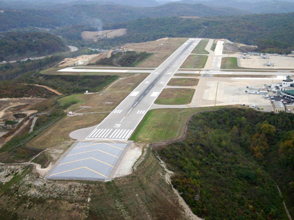 Jet Airports:
- Yeager Airport, Charleston: 1 hour
- Greenbrier Valley Airport, Lewisburg: 1 hour 30 minutes
- Raleigh County Memorial Airport, Beckley: 45 minutes
SURROUNDING AREA

Roaring River is centrally located in one of the most popular outdoor recreation destinations in the U.S. More than three million visitors tour the region annually, climbing rocks, paddling streams, hiking, biking, and running on miles of scenic trails. Interestingly, the Boy Scouts of America established its National Jamboree site here because of its unparalleled access to world-class outdoor recreation. In the winter, the area attracts another clientele—skiers bound for the slopes at Winterplace, a drive of 40 minutes to the south, and Snowshoe Mountain, a two-and-a-half-hour drive to the northeast.
Additionally, the Roaring River location benefits from its proximity to Adventures on the Gorge, one of the most popular outdoor adventure resorts in the U.S. As a pioneer in the whitewater rafting industry, the resort has played a crucial role in driving high-end economic development in the region, making it a hotspot for adventure seekers.
Roaring River also enjoys more than its share of singular shops, pubs, and restaurants, many of which cluster around Fayetteville, a five-minute drive from the property. For even more exceptional eateries and retail destinations, you can explore in just an hour’s drive the west of the state capitol at Charleston, and an hour the east historical Lewisburg, which, according to the National Geographic Magazine, is ranked one of the most livable small towns in the U.S.
The region is perhaps best known as one of the most popular rock-climbing destinations in the world. Thousands of climbers annually scale the more than 60 miles cliff on the gorges of the New, Gauley, and Meadow rivers. Outside Magazine rated the New River Gorge the third most popular climbing area in the U.S. in 2019. It includes some of the most attractive sports climbs in the Western Hemisphere. Notably, the American Alpine Club maintains an ecologically integrated campground for climbers less than a mile from the frontage.

In recent years, the region has also witnessed a rise in the number of hikers, paddlers, and bicyclists attracted to its limitless recreative landscape. USA Today, in 2015, named the Endless Wall Trail—a drive of only 20 minutes from the property—the best hiking trail in the U.S. national park system. Whitewater rafting has long been a mainstay of tourism on the New and Gauley Rivers, though kayaking has grown tremendously throughout West Virginia, outpacing the growth of the pastime nationally.
The region is also renowned as a paradise for golfers, boasting more than a score of courses within just an hour’s drive. This includes three at the famous Greenbrier, which sometimes hosted both the PGA and LIV tour and three at nearby Glade Springs Resort. Also, the Oakhurst Links, the first course in the U.S., is just over an hour’s drive.
Accessing the area is easy. The US-19 expressway travels through the heart of the region, and Interstates 77 and 64 area are only a half-hour drive by expressway to the south at Beckley. Interstate 79 is a 45-minute drive by expressway to the north. The state capital, Charleston, is an hour’s drive west and accessible by several routes.
For train travel, the Amtrak passenger stations on the Chicago-New York route are located half an hour to the south near Beckley and an hour’s drive east and west at Charleston and White Sulphur Springs.
Public airports that offer jet service are located 40 minutes to the south at Beckley and an hour west and east at Charleston and Lewisburg. For smaller aircraft, local airfields within a five-minute drive from the property accommodate small and private planes, providing options and convenient access for all types of travel.
RECREATION
Residency in the New River Gorge region offers access to a seemingly limitless variety of recreational pursuits. Its parks invite hiking, biking, fishing, hunting, paddling, rock climbing, ziplining, and whitewater rafting. The area accommodates several walking and field sports facilities, including stadiums, playgrounds, and walking and biking trails. The winter months are not let out—Winterplace is an hour’s drive south, offering skiing and snow-tubing.

Local Recreation
- Adventures on the Gorge, ACE Adventure Resort/Whitewater: 15 minutes
- Babcock State Park: 35 minutes
- Cunard New River Access: 10 minutes
- Golf Course – Bridge Haven Golf Course on the Gorge: 5 minutes
- Kaymoor Trail Head and Brooklyn Trail Head at Cunard: 10 minutes
- Kaymoor Miners Trailhead: 10 minutes
- Lake – Summersville Lake, Summersville: 35 minutes
- New River Gorge Bridge, Fayetteville: 15 minutes
- Summit Bechtel Reserve, Oak Hill: 20 minutes
FOREST/TIMBER RESOURCES

The abundant timber resource, consisting of about 785 acres, is well positioned for current timber income and value appreciation over the coming decades. With an attractive mix of species, adequate stocking levels, and favorable diameter class distribution, the timber amenity represents a strong value component for investors.
Roaring River’s Forest resource is rich in quality Appalachian hardwoods and native Eastern Hemlock. This timber resource has the potential to provide flexibility for future owners in terms of opportunities for harvest revenue that could be managed to provide cash flow opportunities to offset holding costs and contribute to long-term asset appreciation. Although Capital Timber Value for the timber and pulpwood has not been determined at this time, the potential is glaring.
The forest’s predominately well-drained upland terrain has led to a resource dominated by hardwood species. Overall, the species composition is highly desirable, favoring Appalachian hardwood types like Black Walnut, Sugar Maple, Poplar/Basswood, Red Oak Group, White Oak/Chestnut Oak, Soft Maple, Hickory, Beech, and a host of associated species (ash, hemlock, birch, sourwood, black gum, beech).
The forest at Roaring Rivers is fully stocked, providing the next ownership with a great deal of flexibility in shaping their own silvicultural legacy. Across the property, stem quality can be considered excellent, and the timber component has been well managed over the years, consisting of stands of varying age classes. Most timber stand ranges from 30 to 140 years old stems, with diameters between 10 and 40 inches at breast height (dbh).

Diameters are well represented across the commercial spectrum with a notable mature size class, abundant pole-size timber, and growing stock. Scattered throughout the forest and old field edges are several “Heritage Trees,” some as old as 200-300 years. These ancient trees have withstood the test of time, weathering ice, wind, lightning strikes and fire.
The forest is healthy, and there are no signs of pest infestations of Gypsy Moth. The Emerald Ash Borer, which has inundated the entire Northeast U.S., is present, and the Ash component will significantly decline over the next decade. Also, the Eastern Hemlock species is under siege by the Hemlock Wooly Adelgid, and the hemlock will significantly decline over the coming decade. Thankfully, there have been no forest fires in recent memory.
The forest floor is a dynamic ecosystem, home to several types of mushrooms, medicinal plants, wild ginseng, ferns, and cool green mosses. There are a few fruit trees scattered about, some of which were part of the early homestead. Crops of black walnuts and hickory nuts are produced each year from the black walnut and hickory trees scattered about.
This environment would be ideal for Honeybees, and it would be possible to produce maple syrup from the sugar and red maple trees growing on the property.
WILDLIFE

The New River is a major contributor to the local ecosystem richness and diversity, providing a home for many plants and animals. There are many animals that live year-round and at other times in the river and its surrounding edges, including beavers, otters, minks, raccoons, opossums, blue herons, Canada geese, wood ducks, mallards, kingfishers, minnows, native fish, turtles, salamanders, newts, crayfish, muskrats, bullfrogs, eagles, owls, hawks, and redwing blackbirds.
The miles of “edge effect” created by the river banks benefit all the resident wildlife. In addition to those listed above, white-tailed deer, black bears, wild turkeys, squirrels, rabbits, bobcats, foxes, and chipmunks make up the resident wildlife population.
The region serves as a haven for birdwatchers; it harbors winged wildlife such as Peregrine falcons, Neotropical songbirds, turkey, grouse, eagles, herons, hawks, woodcock, owls, ravens, kingfishers, ravens, crows, ground nesters, hummingbirds, and a variety of waterfowl.
Of equal importance, the insect and microscopic world, including butterflies, dragonflies, water skaters, water beetles, damselflies, hellgrammites, tadpoles, and various insect larvae, all flourish well and contribute to the ecosystem.
Great fishing is found in the New River, with small and largemouth bass, crappie, catfish, muskie, walleye, pike and bluegill present in good numbers. The river and the surrounding aquatic plant life create a water-supported community, supporting a wide variety of wildlife.

The hardwood forest of the surrounding mountains enriches the environment, providing essential nutrient sources and producing tons of hard mast, including acorns, hickory nuts, beech nuts, and black walnuts. Soft mast includes stag horn sumac, black cherry, tulip poplar seeds, maple seeds, autumn olive berries, and blackberries.
WATER RESOURCES

The property features two dashed blueline streams, with portions running inside its boundaries. One stream begins on the property and runs through the property for about ½ mile. The other stream has its headwaters on the property for about 4/10 miles. Additionally, a blueline branch of Coal Run has a section on the property alongside Cunard Road for about 4/10 miles. These streams are expected to maintain steady water flow, especially during rain events and periods of snowmelt.
DEED and TAX INFORMATION
Deed Information: The primary purchase deed is DB 664 Pg. 660 followed by several deeds for smaller land purchases and some conveyances.
Fayette County, West Virginia
Acreage: 811 acres +/-
Real Estate Tax ID/Acreage/Taxes:
Fayette County (10), West Virginia
Plateau District (2)
The primary large tract is Tax Map 9 Parcel 87 plus several smaller tax parcels.
2023 Real Estate Taxes: $7213
MINERAL RESOURCES
West Virginia law provides for separate ownership titles for surface rights and mineral rights. This property is being conveyed with surface rights only.
BOUNDARIES AND SURVEY

Property boundary survey descriptions are of record, and portions of the property boundary runs alongside state roads. Notably, the property shares about 3 miles of common boundary with the New River Gorge National Park and Preserve. The property is being sold by the boundary and not by the acre.
UTILITIES
Water: Public water is not currently available. WV American Water is the provider and would need to extend the water line.
Sewer: Private Septic System will need to be installed as needed.
Electricity: Available at the frontage.
Telephone: Cell service is available through multiple carriers.
Internet: Internet may be available through multiple carriers, including Starlink Satellite System.
ACCESS/FRONTAGE

- The property has frontage on Gatewood Road.
- It has approximately 1 mile of frontage on Cunard Road and ½ mile or more of frontage on Elverton Road, both of which are public road system.
- There are approximately 8 miles dedicated to an internal road system.
ZONING

Fayette County is subject to some zoning and subdivision regulations. All prospective buyers should consult the County Commission and also the Health Department for details regarding zoning, building codes, and installation of septic systems.
PROPERTY TYPE/USE SUMMARY
The property features a large 26 +/- acre field along Elverton Road, with the remaining property consisting mostly of forested land.
DINING & RETAIL
The property is centrally located between the New River Gorge and Kanawha Valley regions and enjoys access to a variety of dining and shopping venues in both directions. Nearby, the Fayetteville area offers a charming collection of over a dozen noteworthy independent restaurants catering to locales and visitors seeking impeccable dining experiences. An hour’s drive west, the Charleston metropolitan area boasts the state’s highest concentration of restaurants and retail centers.
ADVENTURES ON THE GORGE
Less than 15 miles from the property is one of the nation’s leading outdoor-adventure resorts, Adventures on the Gorge. Locals and their guests are welcome to take advantage of the resort’s restaurants, pubs, outfitter shop, canopy tour network, and gorge-view swimming pool. Whether you seek whitewater rafting, rock climbing adventure, or just a relaxation time by the water, you will find your place.
FAYETTEVILLE
The county seat of Fayette County, Fayetteville, is perhaps renowned as the outdoor-recreation capital of southern West Virginia. Thousands of tourists visit the town annually, perusing its outfitters and dining in its unique pubs and restaurants. A drive of about 10 minutes from the property, it’s also home to the county’s chief shopping district, which includes many national chain stores and restaurants. The town’s population was estimated at 2,782 in 2018, making it a fun and bustling community.
HEALTHCARE
Hospitals with emergency care units are located nearby in Oak Hill (25 minutes away) and Montgomery (35 minutes from the property). State medical centers at Charleston and Morgantown are an hour’s drive west and a two-and-a-half-hour drive north. A Veterans Administration Medical Center is located at Beckley, a drive of just less than an hour south. The nearest hospital to the property, Oak Hill General Hospital, is a drive of approximately 25 minutes. The area is well served by several medical and emergency care clinics throughout the upper Kanawha Valley region. For a healthy lifestyle, the area’s moderate climate and access to trails, gymnasiums, and athletic centers support healthy living.
VETERANS MEDICAL
Veterans in West Virginia can access several VA Hospitals, including those in Beckley, Clarksburg, Martinsburg, and Huntington. Additionally, nearby Community-Based Outpatient VA Clinics are available in Clarksburg, Gassaway, Parkersburg, Parsons, Petersburg, Princeton, Ronceverte/Lewisburg, South Charleston, and Westover, West Virginia.
TRANSPORTATION
- Motor Vehicle Access: The property is well-connected to major interstate expressways 77 and 64, and US-19, which are nearby, providing easy access to cities like Richmond, Charlotte, Columbus, Pittsburgh, Cincinnati, and Washington, D.C.
- Flight: Yeager Airport at Charleston is the largest and busiest flight-service center in the region.
- Rail: The Amtrak passenger station at Montgomery is just a 30-minute drive from the property and provides direct access to Charleston, Washington, Chicago, and New York City.
Approximate drive times to regional U.S. cities include:
Fayetteville, WV: 10 minutes
Oak Hill, WV: 15 minutes
Beckley, WV: 35 minutes
Lewisburg, WV: 1 hour 15 minutes
The Greenbrier Resort: 1 hour 30 minutes
Snowshoe, WV: 2 hours 20 minutes
Princeton, WV: 1 hour
Bluefield, WV: 1 hour 30 minutes
Summersville, WV: 25 minutes
Flatwoods, WV: 1 hour
Clarksburg, WV: 1 hour 50 minutes
Wheeling, WV: 3 hours 30 minutes
Huntington, WV: 2 hours 30 minutes
Charleston, WV: 1 hour
Morgantown, WV: 2 hours 30 minutes
Columbus, OH: 2 hours 30 minutes
Pittsburgh, PA: 3 hours 30 minutes
Cincinnati, OH: 4 hours
Charlottesville, VA: 3 hours 30 minutes
Richmond, VA: 4 hours 30 minutes
Winston-Salem, NC: 3 hours 30 minutes
Charlotte, NC: 4 hours
Washington, DC: 5 hours
CLIMATE
The Gorge sustains a microclimate more typical of warmer, southerly latitudes due partly to the sheltering nature of its narrow valley. Though the river may appear as a large mountain stream, it has already traveled more than 300 miles from the summits of the Blue Ridge in North Carolina and has heated over time. This creates a warmer and more temperate microclimate that is ideal for gardening and offers a longer growing season. The gorge remains relatively free of heavier snow that blankets the surrounding highlands.
The mean annual precipitation at the property is estimated at 37 to 47 inches, with a mean annual air temperature between 50 to 52 degrees F and a frost-free period lasting 140 to 170 days.
PUBLIC & PRIVATE SCHOOLS
The area offers solid selections of both public and private schools. Public school students living in the Chimney Corner area may attend Ansted Elementary School, Oak Hill Middle School, Midland Trail High School, or Oak Hill High School. Several options are available in the area as well for those seeking to attend private schools.
HIGHER EDUCATION
The property is a drive of 30 miles from Bridgeview Community College at Montgomery. Several other institutions of higher education are located within a short drive. An hour’s drive to the west, the University of Charleston reports a student population of 2,949 in 2014. To the south, Beckley serves as the higher-education center of southern West Virginia and is notably the site of West Virginia University’s southern campus, which reported 1,622 students as of 2018. Marshall University at Huntington, a drive of about an hour and a half and a population of over 12,000 students in 2022, is the region’s largest university.
OAK HILL
Oak Hill is the largest municipality in Fayette County, with an estimated population of over 8,200 residents. Like Fayetteville, which it adjoins to the south, Oak Hill is strongly tied to outdoor recreation and home to the largest city-owned rock-climbing park in the U.S. Its downtown business district and six expressway exits on US-19 make it a hub of commercial activity.
THE SUMMIT


As a result of unrivaled access to recreation, the Boy Scouts of America established its national Jamboree site on more than 12,000 acres at the Bechtel Family National Scout Reserve, also known as The Summit. The organization has since invested more than $400 million in the acquisition and buildout. The Summit also hosts the national leadership center for the scouts and serves as one of its five high-adventure bases. The World Jamboree in 2019 saw more than 50,000 attendees from over 40 countries.
NEW RIVER GORGE BRIDGE
The New River Gorge Bridge arcs across the chasm of the New River Gorge like a rainbow of dusky metal, spanning more than 3,000 feet. Now a national historical landmark, it was designed to complement the gorge while completing a vital expressway through the Appalachians. When it opened in 1977, it was the longest of such bridges in the world, a marvel that reduced drive time across the gorge from 40 minutes to less than a minute. It is among the most photographed landmarks in West Virginia. The National Park Service has opened its Canyon Rim Visitor Center at the north end of the span, offering visitors the chance to tour the bridge’s catwalk—an interesting experience suspended more than 800 feet above the river.
BABCOCK & HAWKS NEST STATE PARKS
Located to the east and west of the property, State Parks Babcock and Hawks Nest feature two of the most scenic landscapes in the state, as well as remarkable lodging and recreational opportunities. The largest state park in West Virginia, Babcock may be best known for its beautiful gristmill, photos of which adorn puzzles and postcards globally. The park is also known for its rustic cabins, many of which are hewn of massive logs laid by members of the Civilian Conservation Corps. Hawks Nest is renowned for its clifftop views of the New River Gorge and for its scenic aerial tramway, which carries guests to the New River and back to the Hawks Nest Lodge. Hawks Nest also boasts corps-built historic structures of stone and timber.
GEOLOGY

The New River Gorge is one of the world’s oldest river systems, estimated by some geologists to be 320 million years old. The river’s formation predates the uplift of the surrounding mountains, through which the river has cut its winding channel. The defining feature of the gorge is its sharply defined rim, along which massive cliffs are outcropped. Extending for some ten miles along the river from Sewell to Hawks Nest, the gorge lends its name to the New River Gorge National River, which includes much of the formation as well as the steep-walled New River Valley that extends upstream to near Hinton.
The cliffs along the rim of the gorge are made up of extremely durable sandstone, the durability of which has resisted erosion, creating tablelands that extend for miles beyond the rim. This durability, vertical cracks, and cliff height exceeding 100 feet in some areas have helped make the gorge a premier rock-climbing destination in the U.S.
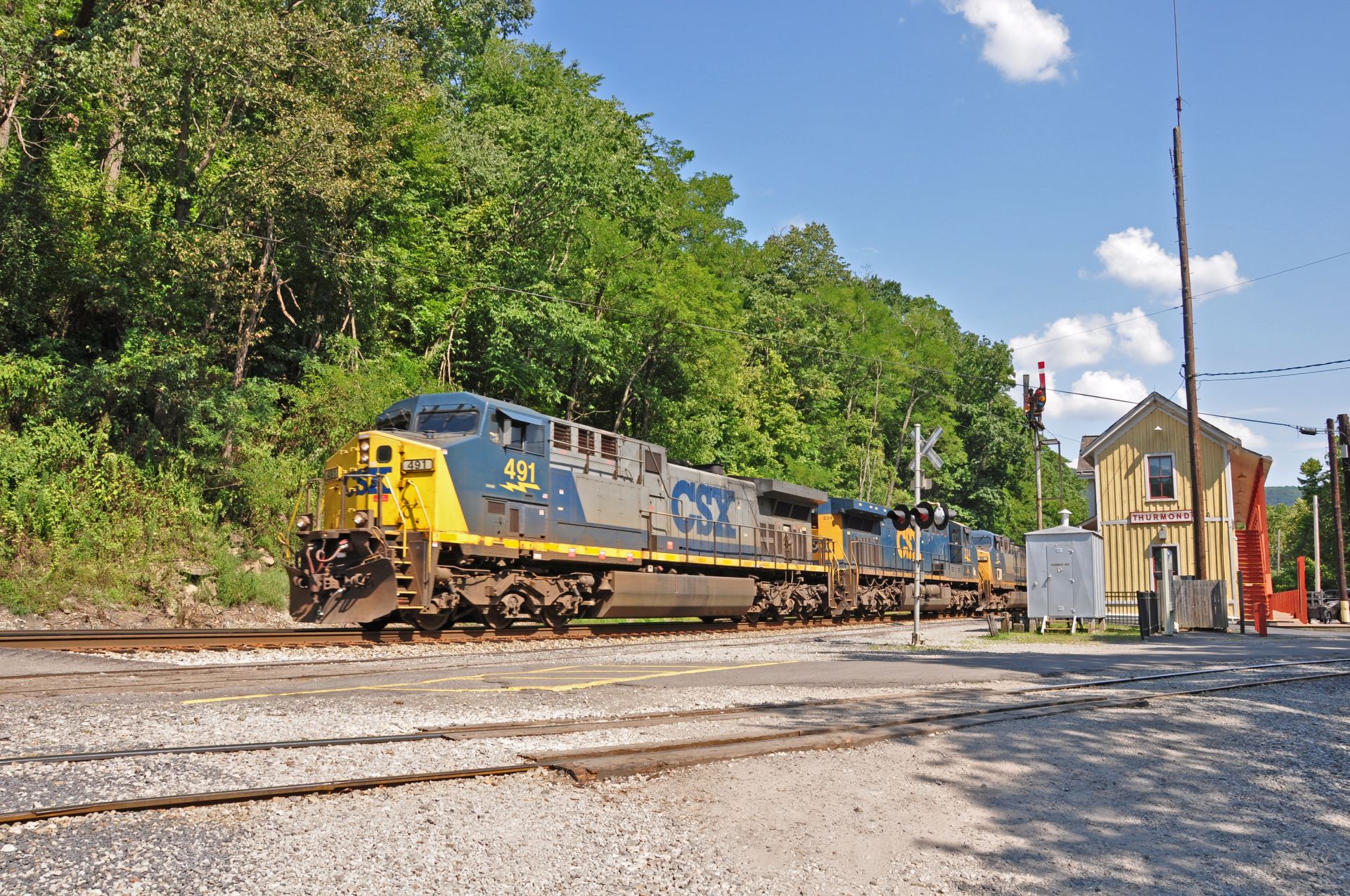
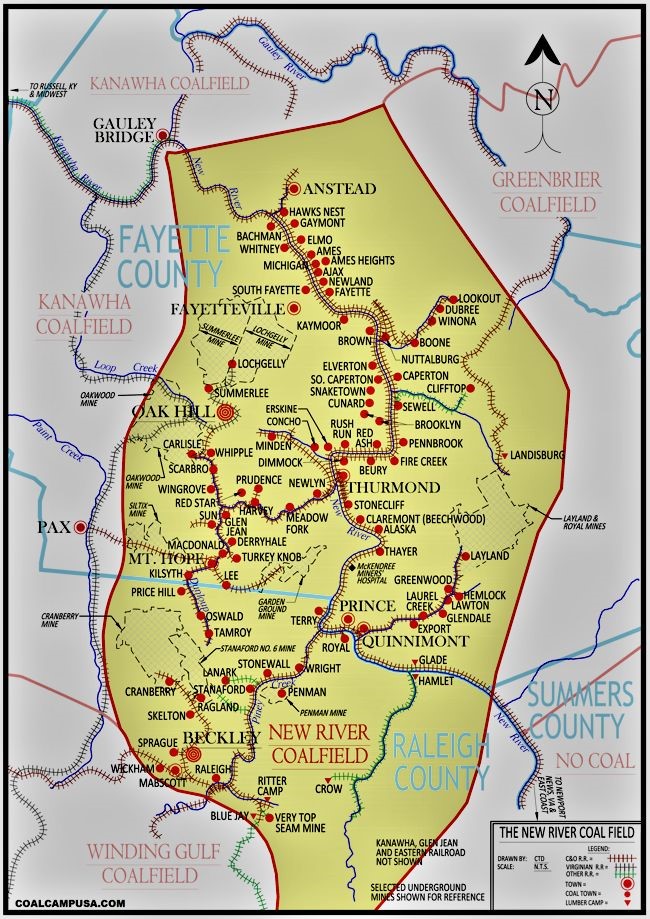
THE NEW RIVER COAL FIELD 1872 to 1980
The New River Coalfield was once one of the most prosperous coal mining regions in the nation. It included over 60 mines, with dozens in the 14-mile stretch of the New River known as the New River Gorge. Renowned for producing high-quality, low-volatile coal, the miners prided themselves on mining what was regarded as some of the best coal in the nation.
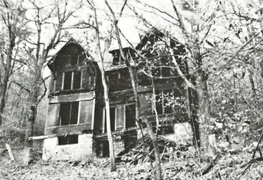
By the 1950s, coal mining in the gorge had disappeared into history, and many of the buildings in these once-thriving communities had returned to the earth. However, there are a few places within the Gorge where the traces of a once-thriving mining life can still be seen. (Reprinted from ACE)
CAPERTON, WV (1881 – 1955)
Roaring River adjoins the Caperton coal complex, which was established in 1881 and is now a part of the New River Gorge National Park and Preserve, featured as one of the historic sites open to visitors. Caperton was established sometime in the late 1880s as a joint venture by three major industrialists, Joseph Beury, John Cooper, and George H. Caperton. The community itself was not originally called “Caperton.” It was first settled as “Elm,” a small mining town established for a mine located in the Fire Creek seam of coal. The name was later changed in honor of George Caperton due to his ability to manage the site and accompanying mine.
By 1889, Caperton had expanded to include not only the main mine on the north side of the river but also a second mine, named South Caperton, which was opened across on the south side of the river around 1910. Coal was transported across to the #1 tipple and over 200 coke ovens using an aerial tramway cable. Another such tramway was used upstream at the Royal Coal mine across the river from Prince.
At the height of Caperton’s production, the community housed over 500 residents. Homes and shanties dotted the hillside up and down the river to accommodate the growing workforce needed to operate the tipple or processing facility. A long 500-foot walk bridge was constructed across the river to facilitate access to the South Caperton mine and community.
Like many coal mines in the New River Gorge, Caperton mined the Sewell seam of coal, located about 1,000 feet above the riverbanks. The solution to transport the coal from the mine site down to the tipple was an engineering feat.

Unlike the mine at Nuttalburg, a little over a mile downstream from Caperton, which used an extremely long, “button and rope” conveyor system, Caperton’s approach was different. Long rope cables were used to pull monitor cars up and down the steep hillside to transport the coal. Monitor cars were 10 feet long, with 4-foot-wide round iron cylinders set on wheels mounted on small railroad tracks so that the cars would traverse up and down the hillside. Monitor cars were widely used in the New River region, with other mines, such as the Fayette Mine, adopting the same equipment.
In total, Caperton operated three coal mines in the area. Some sources believe that the company may have processed coal from other mines in the area because of the number of coke ovens in operation.
The beehive-style coke ovens, which were typical in the New River, operated 2 hours a day, burning continuously. These ovens were used to turn the coal into coke and then send them north to steel mills. The ovens were shut down only when they needed to be refilled with coal, emptied of coke, or when carrying out maintenance work on them.

Caperton 200+ beehive coke ovens ran night and day.
Interestingly, only one mine site—the Red Ash mine, located upstream from on the south side of the river, used a more Belgian or “breadbox” shape coke oven. It is the only site in the New River Gorge to use such designs.
Both the two systems used to transport coal from the Caperton mine and the South Caperton mine consisted in using steel rope cables. It has been estimated that the monitor system that transported the coal from the Caperton mine to the tipple below required nearly four thousand feet of cable. The aerial tramway running across the river to the South Caperton mine required an incredible nineteen thousand feet. Once the coal reached the tipple, it was either processed and used in making coke or sold as raw material as customers’ needs dictated. © 2023 – 2024 Heritage Lost
NOTE: This historical account of the coal town of Caperton, WV, was written by R.I. Walker, an author who has written a book series called Legacy, A Pictorial History of Coal Mining in Southern West Virginia, and Legacy, A Different Breed. His third book, Heritage Lost: The New River Gorge, is in the works. For more information, please visit Mr. Walker’s website: https://www.heritage-lost.com
Foxfire Realty greatly appreciates the author granting permission to reprint his article.
DIRECTIONS
From Oak Hill East Main Street Exit of US 19: 7 miles +/- (approx. 15 minutes)
At the end of the exit ramps, turn onto Rt. 16 North; travel 6/10 mile; turn right onto Gatewood Road / E Martin Ave; travel a short distance; turn left onto Gatewood Road; travel 5.9 miles on Gatewood Road; turn right onto Elverton Road; travel 3/10 mile; the field begins on the right.
REGIONAL INFORMATION
STATE INFORMATION
- State of West Virginia
- West Virginia Explorer
- West Virginia Government
- West Virginia State Parks
- West Virginia Tourism
- Wonderful West Virginia Magazine
- WV Department of Natural Resources
- Virginia – Commonwealth of Virginia
- Virginia is for Lovers
- Virginia Museum of History & Culture
- Virginia Museum of Natural History
- Virginia National Park Service
- Virginia Recreation
- Virginia State Parks

Contact Foxfire
304.645.7674
Gallery


